Detalles
Descripción
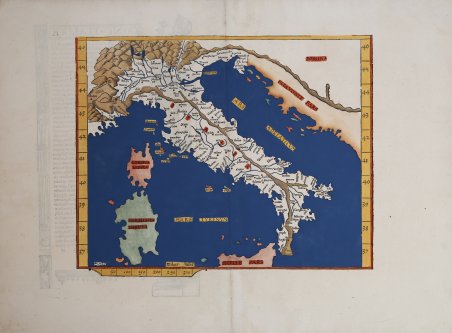
R. Borri "L'Italia nelle antiche carteâ¦" (2011), scheda 25.
Descripción
Carta geografica della penisola, per la prima volta stampata da Laurent Fries nel 1522. La prima edizione della ' Geographia ' di Tolomeo curata da Fries fu pubblicata a Strasburgo nel 1522, con le carte che furono copiate e nuovamente incise da quelle di Martin Waldseemülleer dell'edizione di Tolomeo del 1520 e testo a cura di Pirckheimer. Nel 1525 viene stampata una seconda edizione a Strasburgo. Alla scomparsa del Fries e del Gruninger, le matrici furono acquistate dai fratelli Melchior e Gaspar Treschel che ne stampano una terza edizione a Lione nel 1535. Per il testo i due editori si servirono della supervisione di Michael Servetus, che curò la revisione del testo del Pirckheimer. Infine, nel 1541, Gaspare Treechsel pubblica a Vienne, nel Delfinato, questa quarta edizione, sempre con testo di Serveto. In questa edizione, rispetto alla prima di Strasburgo del 1522, il testo subì numerose modifiche, correzioni e aggiunte, ma i legni non furono modificati. In questa edizione del 1541 viene modificato solo il titolo che non è accompagnato da nastro. Esemplare tratto dall’edizione del 1525, del ' Claudii Ptolemaei Alexandrini Geographicae Enarrationis. Xilografia, finemente colorata a mano, in ottimo stato di conservazione. Map of the peninsula, first printed by Laurent Fries in 1522. The first edition of ' Ptolemy's Geographia ' edited by Fries was published in Strasbourg in 1522, with the maps being copied from those of Martin Waldseemülleer's 1520 edition of Ptolemy and text edited by Pirckheimer. In 1525 a second edition was printed in Strasbourg. At the death of Fries and Gruninger, the plates were purchased by the brothers Melchior and Gaspar Treschel, who printed a third edition in Lyon in 1535. For the text, the two editors used the supervision of Michael Servetus, who edited Pirckheimer's text. Finally, in 1541, Gaspare Treechsel published in Vienne, in the Dauphiné, this fourth edition, again with Servetus' text. In this edition, compared to the first edition of Strasbourg in 1522, the text underwent numerous changes, corrections and additions, but the woods were not changed. In this edition of 1541 is modified only the title that is not accompanied by tape. Example from the ' Claudii Ptolemaei Alexandrini Geographicae Enarrationis, showing text and title on the back, printed in Lyon in 1525. Woodcut, fine later hand colouring, very good condition. Rare. Cfr. R. Borri "L'Italia nelle antiche carte…" (2011), scheda 25.


 Descubre cómo utilizar
 Descubre cómo utilizar