Johnson’s Sweden and Norway / Johnson’s Denmark with Sleswick & Holstein
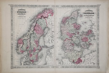
Johnson’s Sweden and Norway / Johnson’s Denmark with Sleswick & Holstein
Formas de Pago
- PayPal
- Tarjeta de crédito
- Transferencia Bancaria
- Pubblica amministrazione
- Carta del Docente
Detalles
- Año de publicación
- 1865
- Lugar de impresión
- New York
- Formato
- 680 X 460
- Grabadores
- JOHNSON Alvin Jewett
Descripción
Magnifica carta della Scandinavia del 1865, divisa in due parti e colorata a mano. La mappa sulla sinistra rappresenta la Norvegia e la Svezia. La mappa sulla destra la Danimarca e le province di Sleswick e Holstein. Le varie aree sono desctitte con notevoli dettagli, tra cui le caratteristiche geografiche politiche e fisiche. La mappa è datata e firmata, "Entered according to Act of Congress in the Year of 1865 by A. J. Johnson in the Clerk's Office of the District Court of the United States for the Southern District of New York". This is a magnificent 1865 hand colored map Scandinavia is divided into two parts. The left map represents Norway and Sweden. The right map depicts Denmark as well as the provinces of Sleswick & Holstein. Depicts the area in considerable detail including both political and physical geographic features. Map is dated and copyrighted, 'Entered according to Act of Congress in the Year of 1865 by A. J. Johnson in the Clerk's Office of the District Court of the United States for the Southern District of New York.' Cfr.