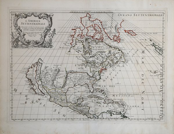
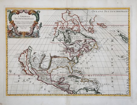
L'America Settentrionale
L'America Settentrionale
Formas de Pago
- PayPal
- Tarjeta de crédito
- Transferencia Bancaria
- Pubblica amministrazione
- Carta del Docente
Detalles
- Año de publicación
- 1677
- Lugar de impresión
- Roma
- Formato
- 560 X 410
- Grabadores
- DE ROSSI Giovanni Giacomo
- Idiomas
- Italiano
Descripción
Carta geografica tratta dal ' Mercurio geografico overo Guida Geografica in tutte le parti del Mondo conforme le Tavole Geografiche del Sansone Baudran de Cantelli Data in luce con direttione, e cura di Gio. Giacomo de Rossi nella sua stamperia ' raccolta di carte edita a Roma tra il 1660 ed il 1730 dalla tipografia De Rossi - la datazione delle carte va dal 1669 al 1715 - la cui prima stesura si deve a Giovanni Giacomo de Rossi. Nel corso degli anni l’atlante fu arricchito da un numero sempre maggiore di carte nelle successive edizioni curate prima da Domenico de Rossi e poi dal figlio Filippo. Il ' Mercurio Geografico ' è una raccolta che raccoglie lavori di cartografi quali Michele Antonio Baudrand, Nicolas Sanson, Augustin Lubin, Filippo Titi, Giacomo Ameti, Giovanni Antonio Magini e Innocenzo Mattei e che ' contempla come "corpus" principale ' la grande produzione del geografo Giacomo Cantelli da Vignola. Le carte sono finemente copiate ed intagliate dai maggiori incisori dell'epoca tra i quali Falda, Widman, Barbey, Widman, Lhuillier, Donia, Mariotti. ' La carta deriva da una mappa molto simile di Guillaume Sanson del 1669. ' Rispetto a quest'ultima, la carta di De Rossi presenta alcune aggiunte, quali l'Islanda, le Isole Britanniche, e il toponimo "C Blanco" sulla costa della California. ' La forma dell'isola di California è quella derivata da Foxe del 1635. La carta è una delle prime rappresentazione dei cinque Grandi Laghi; mostra una configurazione del Mississippi pre-La Salle/Jolliet/Hennepin mal localizzata, spinta ben a ovest rispetto alla sua vera posizione e piuttosto speculativa nel suo percorso. Ottimi dettagli sul Sud-Ovest spagnolo lungo il Rio Grande, con la localizzazione di Taos e Santa Fe nel Nord e l'identificazione di Cibola. Compaiono alcuni nomi dei primi indiani, tra cui gli Apache e gli Zuni. Viene mostrato un Lago de Oro al largo del Golfo di California. Quivera appare nell'odierno Texas, insieme a Granada. La costa orientale del Nord America comprende molti nomi di luoghi antichi, tra cui N. Amsterdam, Chesapeac, Powhata, Gotheburg (un primo insediamento svedese). Primo stato della carta con data 1677; una ristampa reca la data 1687, una terza edizione è databile al 1715. “Seventeenth-century Rome contained the famous publishing house of de Rossi. Two branches of the family used the addresses of the Piazza Navonna, and the Piazza della Pace, the latter was the more important house. The 'house' was founded by Giuseppe de Rossi from at least 1613 and continued until his death in 1639. Giovanni Giacomo de Rossi flourished from 1649 to 1691. In 1677 he published a folio atlas by the title of Mercurio Geografico. It was drawn almost entirely from the cartography of the Sanson family in Paris. It is not known whether it was with their permission, or simple plagiarism, but they are credited. The map of North America is derived from Guillaume Sanson's similar map of 1669, itself drawn from his father Nicolas Sanson's wall map of 1666. It includes the few additions to Guillaume's map such as Iceland, the British Isles and the recurrence of C Blanco on the Californian coastline. The island of California is depicted in the Foxe form of 1635. A second state of the map was issued with just a date change. This has been found to be published until at least 1714, the date of an example of the Mercurio Geografico in the Library of Congress. A third state introduced much new cartography. The most westerly of the Great Lakes are now closed and new information is introduced in western Canada. This appears to be derived from Baron de Lahontan's landmark Carte Generale de Canada of 1703, despite being distorted by pivoting Lago des Assinibouels out to the west. The Mississippi River is depicted in its popular form of the day flowing westward and emptying into the Gulf of Mexico in modern day Texas. The Rio del Nort changes course and flows eastwards into the Gulf of Mexico. A new Stretto d'Anien is placed north o. Map taken from ' Mercurio geografico overo Guida Geografica in tutte le parti del Mondo conforme le Tavole Geografiche del Sansone Baudran de Cantelli Data in luce con direttione, e cura di Gio. ' Giacomo de Rossi nella sua stamperia ' collection of maps published in Rome between 1660 and 1730 by the typography De Rossi - the date of the maps goes from 1669 to 1715 - whose first edition is due to Giovanni Giacomo de Rossi. Over the years the atlas was enriched by an increasing number of maps in subsequent editions edited first by Domenico de Rossi and then by his son Filippo. The ' Mercurio Geografico ' is a collection that brings together works by cartographers such as Michele Antonio Baudrand, Nicolas Sanson, Augustin Lubin, Filippo Titi, Giacomo Ameti, Giovanni Antonio Magini and Innocenzo Mattei, and which includes as its main "corpus" the great production of the geographer Giacomo Cantelli da Vignola. The maps are finely copied and engraved by the major engravers of the time including Falda, Widman, Barbey, Widman, Lhuillier, Donia, Mariotti. ' The map is derived from the work of Nicola Sanson. Unlike the previous Dutch maps, Sanson focuses on geographical and hydrographic information, completely omitting any decorative aspect. Sanson, the most famous French cartographer of modern history, was a cosmographer in the service of Louis XIV, King of France; he equipped his maps with the latest geographical information and the most beautiful and acute engravings of the period. The ' Cartes Generales de Toutes les Parties du Monde ' represents the most important product of seventeenth-century French commercial cartography. De Rossi also includes a dominant island California as Sanson had done. The map was published in De Rossi's "Mercurio Geografico" - this example is the first state of the map dated 1677 (later states appeared in 1687 and c.1715). As well as the island form given to California, De Rossi also shows an interesting delineation of five Great Lakes with the western parts still undefined in this state. Florida is shown in a rather "squat" form yet coastal detail further north, including the Chesapeake, Cape Cod and so on, is very much recognisable. ' Includes a early open ended Great Lakes (one of the earliest appearances of the 5 Great Lakes) and a mislocated pre-La Salle/Jolliet/Hennepin Mississippi Configuration, pushed well West of its true locatin and quite speculative in its course. Nice detail in the Spanish Southwest along the Rio Grande, locating Taos and Santa Fe in the North and identifying Cibola. A number of early Indian names, including the Apaches and Zuni appear. A Lago de Oro is shown off the Gulf of California. Quivera appears in modern day Texas, along with Granada. The East Coast of North America includes many early place names, including N. Amsterdam, Chesapeac, Powhata, Gotheburg (an early Swedish Settlement), According to Burden, it is not known whether De Rossi's work had Sanson's permission or whether it was direct plagiarism - either way, Sanson is credited in the decorative title cartouche at upper right. A good example of Italian cartography and the Europe-wide thirst for knowledge of the New World. “Seventeenth-century Rome contained the famous publishing house of de Rossi. Two branches of the family used the addresses of the Piazza Navonna, and the Piazza della Pace, the latter was the more important house. The 'house' was founded by Giuseppe de Rossi from at least 1613 and continued until his death in 1639. Giovanni Giacomo de Rossi flourished from 1649 to 1691. In 1677 he published a folio atlas by the title of Mercurio Geografico. It was drawn almost entirely from the cartography of the Sanson family in Paris. It is not known whether it was with their permission, or simple plagiarism, but they are credited. The map of North America is derived from Guillaume Sanson's similar map of 1669, itself drawn from his father Nicolas Sanson's wall map of 1666. It includes the few additions to Gu. Cfr.