L'Amerique Meridionale…
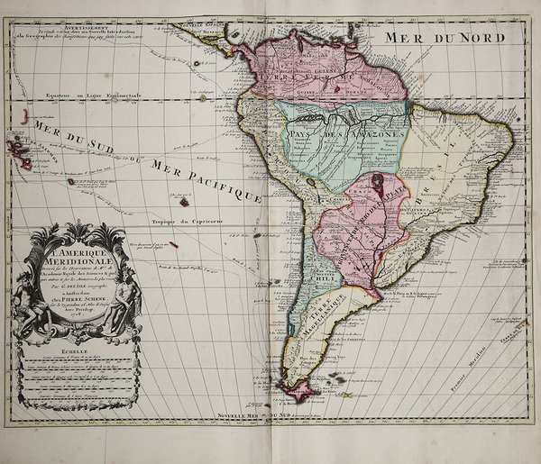
L'Amerique Meridionale…
Formas de Pago
- PayPal
- Tarjeta de crédito
- Transferencia Bancaria
- Pubblica amministrazione
- Carta del Docente
Detalles
- Año de publicación
- 1708
- Lugar de impresión
- Amsterdam
- Formato
- 592 X 455
- Grabadores
- SCHENK Pieter
Descripción
Bellissimo esemplare della carta del Sud America di G. de L'Isle, stampato ad Amsterdam nel 1708. Si tratta di un'ingannevole copia realizzata per il mercato olandese e non della ristampa dallle lastre originali come da molti sostenuto.La mappa del Sud America di De L'Isle ha rappresentato un significativo passo avanti nella presentazione del Sud America su una carta stampata. I dettagli degli interni lungo il Rio delle Amazzoni e il Rio de la Plata sono notevolmente migliorati rispetto alle mappe precedenti, grazie alle informazioni che arrivavano dai missionari gesuiti che erano ormai ampiamente distribuiti in tutto il continente.Nonostante i progressi, ci sono ancora vasti tratti di terre inesplorate e persino le coste del Cile meridionale e della Patagonia sono ancora altamente imprecise.Incisione in rame, coloritura coeva, in ottime condizioni. Pieter Schenck copy of the De L'Isle's map of South America, printed in Amsterdam in 1708.De L'Isle's map of South America represented a significant step forward in the presentation of South America on a printed map. A more streamlined shape is adopted and the interior detail along the Amazon River and Rio de la Plata are significantly improved from earlier maps, owing to the information flowing back from the Jesuit Missionaries who were by now widely disbursed around the continent.Despite the advances, there are still vast tracts of unexplored lands and even the coastlines of Southern Chile and Patagonia are still highly inaccurate.One of the more interesting features on the inclusion of "P. decouvert par F. Drak," shown west of Tierra del Fuego of this mythical island is based on a misinterpretation of Sir Francis Drake's narrative of his circumnavigation of the world in 1577-79. Upon entering the Pacific, after sailing through the Strait of Magellan, Drake's ship was blown southwards by storms. In September 1578, the party encountered an island they called 'Elizabeth Island'. While modern scholars believe it to be one of the islands located in the immediate vicinity of Cape Horn, as is the case here, some believed 'Drake's Island' to have been located much further out to sea.Copper engraving, contemporary colour, in perfect condition. Cfr.