L'Isle de Ré de Basse Marée
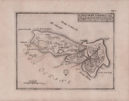
L'Isle de Ré de Basse Marée
Formas de Pago
- PayPal
- Tarjeta de crédito
- Transferencia Bancaria
- Pubblica amministrazione
- Carta del Docente
Detalles
- Año de publicación
- 1693
- Lugar de impresión
- Parigi
- Formato
- 280 X 222
- Grabadores
- DE FER Nicolas
Descripción
Carta geografica tratta da ' Les forces de l’Europe ou description des principals villes… ' Paris: Chez l'Auteur, 1693-1696 ' celebre raccolta composta da otto parti in un volume, in folio oblungo. Les Forces de l’Europe ' è un noto atlante militare francese; prevalentemente si tratta di mappe, piani e vedute di fortificazioni di città europee in Francia, Germania e Paesi Bassi, l'atlante include anche una serie di altre regioni, tra cui Malta, Costantinopoli, Tripoli e altrove. Nicolas de Fer (1646-1720) è stato uno dei più grandi cartografi, incisori ed editori del XVII secolo. Il padre, Antoine de Fer, era un modesto mercante di stampe che lavorava sull’Ile del la Cité a Parigi; collaborò con Nicolas I Berey, poi con Melchior Tavernier e, quindi, con Jacques Lagnet. Nel 1652 Antoine adotta l’insegna commerciale della “Sphére royale”, già appartenuta a Tavernier; nel 1657 stampa ' Cartes de géographie, una piccola raccolta tascabile di Pierre Duval. Nel 1667 si firmava “merchand de cartes Gèographique”; proseguì l’attività fino al 1686, quando lasciò la tipografia nelle mani del figlio Nicolas, che aveva fatto da apprendista all’incisore parigino Louis Spirinx e aveva già realizzato la sua prima mappa del Canal du Midi, all’età di soli 23 anni. Nel 1689 realizzò una mappa della Franche-Comté per onorare il Grand Dauphine - Luigi di Francia (1661-1711), primogenito ed erede del re Luigi XIV di Francia, impegnato al comando di una campagna di conquistare di nuovi territori sul Reno. In seguito, venne nominato geografo ufficiale del Delfinato e la sua produzione fu strettamente legata agli interessi della corona francese: ad esempio, ' Forces De L’Europe Ou Introduction A La Fortification, pubblicato nel 1695, che mostrava le nuove fortificazioni progettate dall’innovativo ingegnere francese Sébastien de Vauban. Fu il geografo ufficiale anche di Filippo V e Luigi XIV (entrambi i rami francese e spagnolo della Casa di Borbone) e infine, nel 1720, del Papa. De Fer pubblicò l’Atlas curieux où le Monde représenté dans les cartes générales et particulièrs du Ciel et de ' la Terre ' tra il 1700 e il 1705, aggiungendo ogni volta delle nuove tavole geografiche. La sua opera più maestosa rimane l’Atlas Royal, dans l’Isle du Palais sur le Quay de l'Orloge a la Sphere royale ' (1693). Alla sua morte, l’attività fu ereditata da suo genero Guillaume Danet, che si unì poi con Jacques-François Benard. Acquaforte, in buono stato di conservazione. Map from ' Les forces de l'Europe ou description des principals villes ' . Paris: Chez l'Auteur, 1693-1696 ' famous collection consisting of eight parts in one volume, oblong folio. Les Forces de l'Europe ' is a well-known French military atlas; predominantly maps, plans and views of fortifications of European cities in France, Germany and the Netherlands, the atlas also includes a number of other regions, including Malta, Constantinople, Tripoli and elsewhere. Nicolas de Fer (1646-1720) was one of the greatest cartographers, engravers and publishers of the 17th century. His father, Antoine de Fer, was a modest print merchant working on the Ile del la Cité in Paris; he collaborated with Nicolas I Berey, then with Melchior Tavernier, and then with Jacques Lagnet. In 1652 Antoine adopted the "Sphére royale" trade sign, which had already belonged to Tavernier; in 1657 he printed ' Cartes de géographie, a small pocket collection by Pierre Duval. In 1667 he signed himself "merchand de cartes Gèographique"; he continued the business until 1686, when he left the print shop in the hands of his son Nicolas, who had been apprenticed to Parisian engraver Louis Spirinx and had already made his first map of the Canal du Midi, at the age of only 23. In 1689 he made a map of Franche-Comté to honor the Grand Dauphine - Louis of France (1661-1711), eldest son and heir of King Louis XIV of France, who was engaged in commanding a campaign to conquer new territories on the Rhine. He was later appointed official geographer of the Dauphiné, and his output was closely linked to the interests of the French crown: for example, ' Forces De L'Europe Ou Introduction A La Fortification, published in 1695, which showed the new fortifications designed by the innovative French engineer Sébastien de Vauban. He was also the official geographer of Philip V and Louis XIV (both the French and Spanish branches of the House of Bourbon) and finally, in 1720, of the Pope. De Fer published theAtlas curieux où le Monde représenté dans les cartes générales et particulièrs du Ciel et de la Terre ' between 1700 and 1705, adding new geographical plates each time. His most majestic work remains the ' Atlas Royal, dans l'Isle du Palais sur le Quay de l'Orloge a la Sphere royale ' (1693). Upon his death, the business was inherited by his son-in-law Guillaume Danet, who later joined forces with Jacques-François Benard. Etching, very good condition. Cfr.