Latii Utriusque delineatio
Latii Utriusque delineatio | Grabados | CELLARIUS Christoph

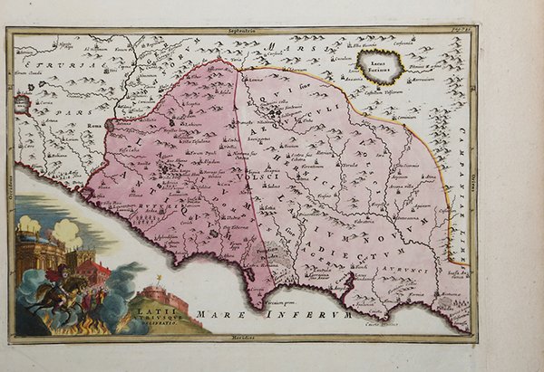

Latii Utriusque delineatio
Latii Utriusque delineatio | Grabados | CELLARIUS Christoph
Formas de Pago
- PayPal
- Tarjeta de crédito
- Transferencia Bancaria
- Pubblica amministrazione
- Carta del Docente
Detalles
- Año de publicación
- 1701
- Lugar de impresión
- Amsterdam
- Formato
- 310 X 210
- Grabadores
- CELLARIUS Christoph
- Materia
- Carte Storiche
Descripción
Carta storica del Lazio tratta dal Notitia orbis antiqui, siue Geographia plenior, ab ortu rerumpublicarum ad Costantinuorum tempora orbis terrarum faciem declarans. Christophorus Cellarius ex vetustis probatisque monimentis collegit, & nouis tabulis geographicis, … illustrauit. Adiectus est index copiosissimus locorum & aliarum rerum geographicarum edito per la prima volta nel 1701 e ristampato fino al 1774. Incisione in rame, bella coloritura coeva, in ottimo stato di conservazione. This 'ancient geography' map shows Rome and the west side of Italy.Original copperplate-engraved map on hand-made paper, published for the 1732 edition of Geographia Antiqua (Antique Geography) by German Scholar Christopher Keller (known as Cellarius) (1632-1707). First published by Cellarius in 1686, this work was reissued many times, until 1812. The 1732 edition was larger and more attractively presented. Many of the maps had decorative cartouche title pieces. This wonderful cartouche shows grand buildings of Rome, fire and smoke, and the army on horseback.In good condition, this map would have been published in black and white. It has fine later hand-tinting with watercolour, that certainly adds to the attractiveness of the map. Cfr.
