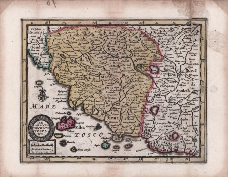
Le Grand Duché de Toscane
Le Grand Duché de Toscane | Grabados | VANDER AA Pieter
Le Grand Duché de Toscane
Le Grand Duché de Toscane | Grabados | VANDER AA Pieter
Formas de Pago
- PayPal
- Tarjeta de crédito
- Transferencia Bancaria
- Pubblica amministrazione
- Carta del Docente
Detalles
- Año de publicación
- 1714
- Lugar de impresión
- Leyda
- Formato
- 185 X 145
- Grabadores
- VANDER AA Pieter
Descripción
Rarissima mappa tratta dal "Nouveau Petit Atlas - Atlas soluagé de son gros pesant Fardeau" stampato a Leida, nel circa 1714. L’atlante è incredibilmente raro e solo una copia completa è conosciuta nella biblioteca di Leida, mentre Burden possiede solo il primo volume. è composto di nove parti: una parte generale denominata “Nouveau Petit Atlas” e 8 parti con mappe regionali intitolate “Atlas Soulage de son gros e pesant Fardeau”. Quasi tutte le mappe vengono stampate utilizzando e rielaborando le lastre di Janssonius per il suo “Atlas Minor”, atlante di ispirazione mercatoriana che prima Jodocus Hondius jr. e Pieter Kaerius, ' poi Johannes Janssonius ampliarono e aggiornarono. I titoli e la scala sono stati tradotti in francese. I cartigli sono stati modernizzati, con una forma tonda od ovale composta e delle rose dei venti aggiunte. Alcuni toponimi sono aggiunti, come si nota dalla diversa grafia incisa. Le carte dell’Italia provengono dall’ottava ed ultima parte dell’atlante, denominata “L’Atlas Soulagé de son gros & pesant fardeu: Ou ' NOUVELLES CARTES GEOGRAPHIQUES ' qui contiennent ' l’ITALIE, ' avec le Paryies principales qui la composent comme l’Etat del L’eglise, Naples, Sicile, &c. Ouvage propre pour Vouager commodement & agréablement des Yeux”. Acquaforte, con coloritura coeva, strappo restaurato in alto a destra, per il resto in ottime condizioni. Grandissima rarità cartografica. Very rare map from the "Nouveau Petit Atlas - Atlas soluagé de son gros pesant Fardeau" printed in Leiden, circa 1714. The atlas is incredibly rare and only one complete copy is known in the Leiden library, while Burden owns only the first volume. it consists of nine parts: a general part called "Nouveau Petit Atlas" and 8 parts with regional maps entitled "Atlas Soulage de son gros e pesant Fardeau". Almost all of the maps are printed using and reworking Janssonius' plates for his "Atlas Minor", a Mercatorian-inspired atlas that first Jodocus Hondius Jr. and Pieter Kaerius, then Johannes Janssonius expanded and updated. The titles and scale have been translated into French. The cartouches were modernized, with a compound round or oval shape and wind roses added. Some place names are added, as noted by the different engraved spelling. The maps of Italy come from the eighth and last part of the atlas, called "L'Atlas Soulagé de son gros & pesant fardeu: Ou NOUVELLES CARTES GEOGRAPHIQUES qui contiennent l'ITALIE, avec le Paryies principales qui la composent comme l'Etat del L'eglise, Naples, Sicile, &c. Ouvage propre pour Vouager commodement & agréablement des Yeux". Etching, with contemporary coloring, in very good condition. A cartographic rarity. Cfr.
