Le Royaume de Naples divisé en Toutes ses Provinces.
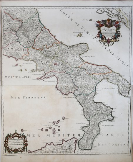
Le Royaume de Naples divisé en Toutes ses Provinces.
Formas de Pago
- PayPal
- Tarjeta de crédito
- Transferencia Bancaria
- Pubblica amministrazione
- Carta del Docente
Detalles
- Año de publicación
- 1706
- Lugar de impresión
- Parigi
- Formato
- 615 X 880
- Grabadores
- JAILLOT Alexis Hubert
- Descripción
- I. Principe "Carte geografiche di Calabria nella raccolta Zerbi", p. 152
Descripción
Le Royaume de Naples divisé en toutes ses Provinces / Dedié a Sa Majesté Catholique Philippe, V. Roy d'Espagne, . ; Par. AH. Jaillot. Magnifica carta del Regno di Napoli del 1703/06 di Hubert Jaillot. Jaillot, insieme al resto della cartografia, sembra seguire in larga misura il modello stabilito da Magini quasi un secolo prima; la sua rappresentazione delle isole Tremiti suggerisce che la sua fonte diretta - come per molte delle mappe di Jaillot - fosse una carta dell'Italia prodotta da Nicolas Sanson. La presente carta, tuttavia, è incisa su una scala più grande e presenta dettagli superiori a quelli di qualsiasi prodotto del Sanson. Il titolo e il cartiglio dedicatorio sono incorniciati da una sontuosa bordura. Sono sormontato dalle armi del dedicatario (Filippo V di Spagna e IV di Napoli), affiancate da due allegorie della Fama che suonano la tromba, raffigurati insieme a lance, scudi e frecce che sottolineano l'abilità militare del sovrano. Il foglio settentrionale di questa carta fu inciso da Jaillot nel 1703 (gli esemplari non uniti recano questa data nel margine inferiore del foglio superiore). La parte inferiore, che reca la data nel cartiglio della scala, fu completata nel 1706. Entrambe le mappe furono aggiunte all'Atlas François di Jaillot, che nonostante la datazione del 1695 contiene tipicamente numerose mappe aggiunte successivamente. La mappa sarà ristampata più volte da Covens e Mortier alla metà del XVIII secolo e ancora da Dezauche nel 1785. Questo esemplare di primo stato è probabilmente tratto dall’Atlas Geographique Contenant Les Cartes d'Espagne, de Portugal, et d'Italie ; où sont les Etats de Piémont, de Gênes, de Milan, de Parme, de Modène, de Mantoue, de Venise, de l'Eglise, de Toscane, des Deux-Siciles, des Isles de Corse, et de Sardaigne , et de celle de Malthe. Alexis Hubert Jaillot, nacque verso il 1632 ad Avignon-lès-Saint-Claude. Dall’infanzia Jaillot aveva mostrato un buon talento per l’arte e il disegno e da suo fratello Pierre-Simón aveva imparato la scultura. Durante il conflitto franco-spagnolo la loro città natale fu devastata, e così i due fratelli si trasferirono a Parigi nel 1657. Lì acquisirono presto una certa reputazione e il titolo di “Sculpteur du Roy”. Nel 1665, Jaillot si sposò con Jeanne Berey, figlia di Nicolas I Berey. La fortuna di Jaillot fu di entrare nel mercato cartografico in un momento particolarmente favorevole. All’inizio del 1668, sotto Luigi XIV, per la Francia iniziò un periodo particolarmente fecondo, come conseguenza della costante espansione territoriale c’era una grande richiesta di mappe che rappresentassero le conquiste francesi e le nuove frontiere. In seguito, Jaillot si associò con i figli di Nicolas Sanson, e fu in grado di commercializzare nuove carte con il prestigioso nome Sanson. Il suo atlante del 1681, l’Atlas Nouveau, divenne un tale successo commerciale che fu copiato illegalmente da altri editori. Jaillot non può essere annoverato tra i cartografi dell’epoca come i Sanson e Duval, fu però un abile incisore che seppe intelligentemente sfruttare le risorse che aveva ereditato, facendone opere mirabili. La sua fama crebbe al punto che il 20 luglio 1686 fu nominato “Géographe du Roy” e gli fu assegnata una cospicua pensione annuale; il titolo gli consentì di difendersi dai numerosi contraffattori. Una delle sue opere più belle fu Le Neptune François, o Atlas Nouveau des Cartes Marine. Dall’inizio del diciottesimo secolo la sua produzione di carte diminuì: erano richieste mappe sempre più aggiornate che non era in grado di offrire. D’altronde, i concorrenti più giovani erano geografi del calibro di Guillaume Delisle. Jaillot (m. 1712) cedette, quindi, l’azienda a suo figlio Bernard Jean-Hyacinthe. Incisione in rame, bella coloritura coeva con ritocchi, in ottimo stato di conservazione. This is Hubert Jaillot's magnificent 1703/06 map of the Kingdom of Naples. Jaillot, along with the rest of the mapmaking establishment, appears to be largely following the model set by Magini nearly a century before; his depiction of the islands of Tremiti suggest that his direct source - as with many of Jaillot's maps - was an Italy map produced by Nicolas Sanson. The present map, however, is engraved on a larger scale, and has superior detail to any Sanson we have handled. The title and dedicatory cartouche is framed with a sumptuous border. It is surmounted with the dedicatee's arms (Philip V of Spain, and IV of Naples) which is flanked by two trumpet-blowing avatars of fame, shown in conjunction with spears, shields and arrows emphasizing military prowess. The northern sheet of this map was engraved by Jaillot in 1703 (unjoined examples bear this date in the lower margin of the upper sheet). The lower portion, bearing the date in the scale cartouche, was completed in 1706. Both maps were added to Jaillot's Atlas François, which despite its 1695 dating typically contains numerous maps added later. The map would be re-printed by Covens and Mortier several times in the mid 18th century, and again by Dezauche in 1785. Alexis Hubert was a skilled businessman born around 1632 in Avignon-lès-Saint-Claude. Since childhood Jaillot had shown a good talent for art and drawing and had learned sculpture from his brother Pierre-Simón. During the Franco-Spanish conflict their hometown was devastated, and so the two brothers moved to Paris in 1657. There they soon acquired a certain reputation and the title of "Sculpteur du Roy". In 1665, Jaillot married with Jeanne Berey, daughter of Nicolas I Berey. Jaillot's fortune was to enter the cartographic market at a particularly favorable time. At the beginning of 1668, under Louis XIV, a particularly fruitful period began for France, as a consequence of the constant territorial expansion there was a great demand for maps that represented French conquests and new frontiers. Later, Jaillot joined forces with the sons of Nicolas Sanson, and was able to market new maps with the prestigious Sanson name. His Atlas of 1681, the "Atlas Nouveau", became such a commercial success that it was illegally copied by other publishers. Jaillot cannot be counted among the cartographers of the time such as the Sansons and Duval, but he was a skilled engraver who was able to intelligently exploit the resources he had inherited, making them wonderful works. His fame grew to the point that on 20 July 1686 he was named "Géographe du Roy" and was given a large annual pension; the title allowed him to defend himself against numerous counterfeiters. A fine example with later hand colour, very good condition. Cfr. I. Principe "Carte geografiche di Calabria nella raccolta Zerbi", p. 152