Les Estates du Duche de Milan
Les Estates du Duche de Milan | Grabados | DE FER Nicolas
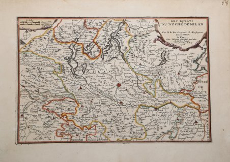
Les Estates du Duche de Milan
Les Estates du Duche de Milan | Grabados | DE FER Nicolas
Formas de Pago
- PayPal
- Tarjeta de crédito
- Transferencia Bancaria
- Pubblica amministrazione
- Carta del Docente
Detalles
- Año de publicación
- 1703
- Lugar de impresión
- Parigi
- Formato
- 325 X 220
- Grabadores
- DE FER Nicolas
Descripción
Carta geografica tratta da "L'Atlas Curieux ou Le Monde Représenté dans des Cartes Générales et Particulières du Ciel et de la Térre" stampato a Parigi da Nicola De Fer tra il 1700 ed il 1705.L'Atlas Curieux ' è una sorta di enciclopedia geografica, che uscì in sei parti annuali tra il 1700 e il 1705.Le tavole sono basate sulle nuove osservazioni dell'Académie des Sciences e sono disegnate e realizzate dal de Fer con l'aiuto di Philipe de La Hire. Nicholas de Fer (1646-1720) era figlio di un venditore di mappe, Antoine de Fer, e divenne uno dei cartografi più noti della Francia del XVII secolo. A dodici anni fu apprendista presso l'incisore Louis Spirinx. Quando il padre morì nel 1673, Nicholas aiutò la madre a gestire l'attività fino al 1687, quando divenne l'unico proprietario. Nel 1697 pubblicò il suo primo atlante mondiale. Dopo la sua morte, avvenuta nel 1720, l'attività passò ai suoi generi, Guillaume Danet e Jacques-Francois Benard.Incisione in rame, in buono stato di conservazione.Bibliografia McLaughlin 1334; Nordenskiöld 72 (re. 1725 ed.); Pastoureau Fer I A. a-d; Phillips 532; Tooley p. 42. Map taken from "L'Atlas Curieux ou Le Monde Représenté dans des Cartes Générales et Particulières du Ciel et de la Térre" printed in Paris by Nicolas De Fer.The "Atlas Curieux" is geographic encyclopedia of images and maps. issued in six annual parts from 1700-1705, the maps are based on the new observations of the Académie des Sciences, and drawn up with the assistance of Philipe de La Hire. Nicholas de Fer (1646-1720) was the son of a map seller, Antoine de Fer, and grew to be one of the most well-known mapmakers in France in the seventeenth century. He was apprenticed at twelve years old to Louis Spirinx, an engraver. When his father died in 1673, Nicholas helped his mother run the business until 1687, when he became the sole proprietor. In 1697, he published his first world atlas. After his death in 1720, the business passed to his sons-in-law, Guillaume Danet and Jacques-Francois Benard.Copperplate, good condition.Literature McLaughlin 1334; Nordenskiöld 72 (re. 1725 ed.); Pastoureau Fer I A. a-d; Phillips 532; Tooley p. 42. Cfr.
