Detalles
Lugar de impresión
Amsterdam
Grabadores
BLAEU Willem Janszoon
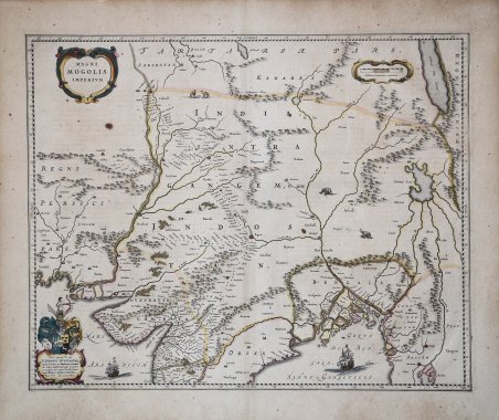
Descripción
Dettagliata carta della regione compresa tra Pakistan, Afghanistan e Bangladesh; estesa alle regioni al di là del Gange ed Indo, comprensiva dell' Himalaia e comprendente Katmandu, Kabul e le altre leggendarie città comprese nelle antiche strade commerciali. Arricchita da elementi decorativi. Willem Janszoon Blaeu, avviò nel 1599 la sua attività di costruttore di globi e strumenti astronomici ad Amsterdam. Nel 1630, dopo aver comprato alcune lastre dell’atlante del Mercator da Jodocus Hondius II, fu in grado di pubblicare un volume di 60 mappe con il titolo di ' Atlantis Appendix. Cinque anni dopo, pubblicò i primi due volumi del suo atlante ' Atlas Novus ' o ' Theatrum Orbis Terrarum, ' in sei libri. Dopo la sua morte, Joan (Johannes) continuò l’opera paterna, completando l’intera serie di sei volume dell’Atlas Novus ' intorno al 1655. Fu inoltre autore di un ' Atlas Maior sive Cosmographia Blaviana, in 12 volumi pubblicati nel 1662 -72. Sebbene pubblicate dopo la morte di Willem Janszoon Blaeu (1638) le carte spesso recano il suo imprint. Non è dato sapere se fossero tutte già pronte o se i figli Johannes e Cornelis le compilarono postume. Incisione in rame, coloritura coeva, in buono stato di conservazione. ' Detailed map of the region bounded by Pakistan, Afghanistan and Bangladesh and extending inland up the Ganges and Indus Rivers to Tartary and the Himalayas, including Katmandu, Kabul and other legendary cities along the great trading routes. Extends south to include a large portion of India, including Narsinga, Orixa Decan, etc.Elephants shown roaming in the Ganges and Camels east of Kabul. Decorative cartouches and sailing ships.Blaeu's map of India was one of the earliest Dutch maps to follow the work of Baffin. William Baffin's map represented a significant leap forward in the mapping and geographical understanding of India, significantly improving on earlier printed maps of India by Mercator and Linschoten. The differences are especially noteworthy in the interior of Baffin's map. The Indus River is shown for the first time in a relatively accurate fashion. Western and most of central India are mapped in a relatively accurate format for the first time. One of the most prominent features which first appears on the Baffin-Roe map is the Longe Walke, the route lined with trees between the palaces at Agra and Lahore. Willem Janszoon Blaeu, started in 1599 his business as a builder of globes and astronomical instruments in Amsterdam. In 1630, after buying some plates of the Mercator atlas from Jodocus Hondius II, he was able to publish a volume of 60 maps under the title Atlantis Appendix. Five years later, he published the first two volumes of his atlas Atlas Novus or Theatrum Orbis Terrarum, in six books. After his death, Joan (Johannes) continued his father's work, completing the entire six-volume Atlas Novus series around 1655. He was also the author of an Atlas Maior sive Cosmographia Blaviana, in 12 volumes published in 1662 -72. Although published after the death of Willem Janszoon Blaeu (1638) the maps often bear his imprint. It is not known whether they were all ready-made or if his sons Johannes and Cornelis completed them posthumously. ' Copperplate with original hand colur, very good condition. Cfr.

 Descubre cómo utilizar
 Descubre cómo utilizar