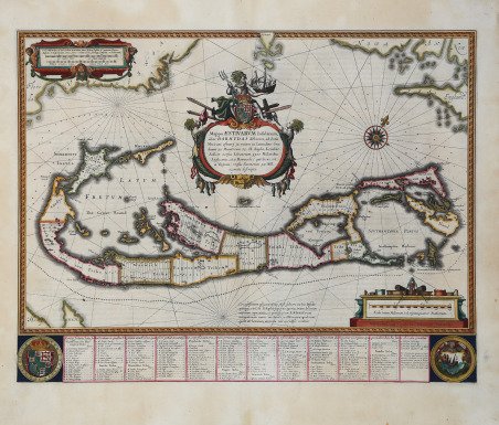
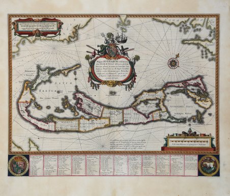
Bell'esemplare della famosa mappa di Willem Janszoon Blaeu delle isole Bermuda, che raffigura anche la terraferma del Nord America. Questa mappa è basata sul rilievo di Richard Norwood per conto della Compagnia delle Bermuda, condotto nel 1617 a bordo di una canoa. Norwood fece una mappa del suo lavoro, registrata nel 1622, ma nessun esemplare di questa carta è oggi conosciuto. John Speed fu il primo a realizzare una derivazione del rilievo di Norwood, che fu inclusa nel suo Prospect of the Most Famous Parts of the World (1627). La lastra per la mappa di Speed fu intagliata da Jodocus Hondius e, dopo la scomparsa di questi nel 1629, venduta a Blaeu, che ne fece una ristampa. ' Willem Janszoon Blaeu, started in 1599 his business as a builder of globes and astronomical instruments in Amsterdam. In 1630, after buying some plates of the Mercator atlas from Jodocus Hondius II, he was able to publish a volume of 60 maps under the title ' Atlantis Appendix. Five years later, he published the first two volumes of his atlas ' Atlas Novus ' or ' Theatrum Orbis Terrarum, in six books. After his death, Joan (Johannes) continued his father's work, completing the entire six-volume ' Atlas Novus ' series around 1655. He was also the author of an ' Atlas Maior sive Cosmographia Blaviana, in 12 volumes published in 1662 -72, one of which was devoted to Italy. Incisione in rame, coloritura coeva con ritocchi, lievissima brunitura, in buono stato di conservazione. Bibliografia Palmer, M. (Bermuda maps) #7; Van der Krogt, P. (Atlantes) 9660:2. Fine example of Blaeu's highly sought-after map of Bermuda, that shows a detailed survey of the islands and the coast of North America. This map is based on Richard Norwood’s survey on behalf of the Bermuda Company, conducted in 1617 from a canoe. Norwood made a map of his work, registered in 1622, but no known example survives today. John Speed created a derivative map which was included in his ' Prospect of the Most Famous Parts of the World ' (1627). The plate for the Speed map was originally made by Jodocus Hondius, the Younger. After Hondius died in 1629, the plate was sold to Blaeu, who re-issued the handsome map. ' The engraving actually includes two maps of Bermuda of different scales. Nestled within the hook of the island is another, smaller depiction of Bermuda, placed there to show its position and size relative to Cape Cod, Nova Scotia and Virginia. (Roanoke, Cape Henry and Cape Charles are all named). This design proved confusing to some later copiers, who dispensed with the mainland in their renditions while mistakenly retaining the smaller ' “Bermuda,” ' thereby transforming it into a small island off the coast of Bermuda. ' Willem Janszoon Blaeu, started in 1599 his business as a builder of globes and astronomical instruments in Amsterdam. In 1630, after buying some plates of the Mercator atlas from Jodocus Hondius II, he was able to publish a volume of 60 maps under the title ' Atlantis Appendix. Five years later, he published the first two volumes of his atlas ' Atlas Novus ' or ' Theatrum Orbis Terrarum, in six books. After his death, Joan (Johannes) continued his father's work, completing the entire six-volume ' Atlas Novus ' series around 1655. He was also the author of an ' Atlas Maior sive Cosmographia Blaviana, in 12 volumes published in 1662 -72. Bibliografia Palmer, M. (Bermuda maps) #7; Van der Krogt, P. (Atlantes) 9660:2. Cfr.

 Descubre cómo utilizar
 Descubre cómo utilizar