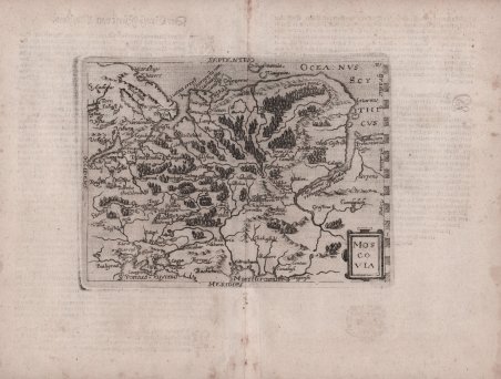
Carta geografica tratta dall’edizione tedesca delle opere di Giovanni Botero, denominata ' Theatrum oder Shawspiegel, ' edita nel 1596 da Lambert Andreas, che nello stesso anno pubblica anche l’edizione con testo latino. L'opera fa parte degli atlanti editi dalla cosiddetta Scuola Cartografica di Colonia, durata per circa mezzo secolo (1570-1620 ca.), e formata principalmente da rifugiati fiamminghi e olandesi tra i quali spiccano lo stesso Matthaeus Quad e Frans Hogenberg, che ne fu il fondatore. Le mappe sono attribuite alcune a Jan Matal ed altre a Michael von Eitzing. Dal punto di vista cartografico le mappe sono una derivazione e basate sulle carte pubblicate ad Anversa da Abraham Ortelius, per la prima volta nel 1570; le incisioni delle mappe sono invece attribuite a Frans Hogenberg. La grandissima rarità dell'opera, insieme alla scarsità di informazioni sulle opere "carbonare" edite a Colonia, contribuisce al fascino di questa importante mappa, caposaldo di ogni collezione cartografica. Ogni raccolta risulta diversa dall’altra, come ampiamente documentato nel saggio di Peter H. Meurer, ' Atlantes Colonienses, Die Kolner Schule der Atlaskartographie 1570-1610. ' Il nostro esemplare corrisponde alla raccolta descritta come BOT 2. Giovanni Botero (1544 – Torino 1617) è stato un presbitero, scrittore e filosofo italiano, autore delle ' Relazioni universali, ' un trattato di geografia politica pubblicato per la prima volta a Roma nel 1591 senza illustrazioni cartografiche. L’opera divenne subito molto importante ed oggetto di studio in tutta Europa, dando inizio praticamente allo studio della demografia. Jan Matal o Metellus, francese di nascita ed attivo a Louvaine ed a Colonia, dove si rifugia proprio per sfuggire alle persecuzioni dei regnanti cattolici e dove muore nel 1597. Fu tra i maggiori cartografi del tempo e, insieme al Quad e al Hogenberg stesso, il principale esponente della scuola coloniese. Alcune delle mappe del Matal sono poi successivamente incluse nelle successive pubblicazioni postume, e recano il testo al verso. Lambert Andreas (attivo tra il 1590 ed il 1598) fu principalmente editore, tuttavia, alcune delle mappe nelle sue pubblicazioni sono a lui stesso attribuite, sebbene in maniera dubitativa. Dal punto di vista cartografico le mappe sono una derivazione delle carte pubblicate ad Anversa da Abraham Ortelius, per la prima volta nel 1570. L’intaglio delle mappe viene attribuito a Frans Hogenberg. Incisione in rame, impressa su carta vergata coeva, consueta piega centrale, piccole ossidazioni, per il resto in ottimo stato di conservazione. Bibliografia Meurer, ' Atlantes Colonienses Die Kolner Schule der Atlas Kartographie 1570-1610, pp. 74/78, BOT 2; cfr. Ginsberg, ' Printed Maps of Scandinavia and the Arctic, pp.150/153, 35 & 36; cfr. Suarez, ' Early Mapping of Southeast Asia, pp. 186/7, 104; cfr. Burden, ' The Mapping of North America, ' p. 115, 90; cfr. Shirley, ' Early Printed Maps of the British Isles, p. 83, 189; cfr. Borri, ' L’Italia nelle antiche Carte, ' p. 95, 106; cfr. Walter, ' Japan a Cartographic Vision, 20; cfr. Tibbets, ' Arabia in Early Maps, ' p. 57, 50. Etching with engraving, without signature. Beautiful impression, printed on contemporary laid paper, showing the usual center fold, small spots, otherwise in excellent condition.The map belongs to the so-called atlases published by the Cartographic School of Cologne. For nearly half a century, Cologne was the most important mapmakers center in the XVI century, mainly due to Dutch and Flemish refugees fleeing religious persecution. Among the principal members of the School, include Quad Matthaeus, Johannes Metellus, Giovanni Botero and Frans Hogenberg, who was its founder. The atlases were often published anonymously or using pseudonyms precisely because of some political and religious problems that characterized the era. Jan Matal or Metellus, French-born Louvaine and is active in Cologne, where he took refuge just to escape persecution from the Catholic monarchs and where he died in 1597. He was one of the major cartographers of the time and, together with the Quad and Hogenberg itself as the leader of the Cologne school. Giovanni Botero (1544 - Turin 1617) was a priest, Italian philosopher and writer, author of universal relations, published a treatise on political geography for the first time in Rome in 1591 without cartographic illustrations. The work quickly became very important and studied throughout Europe, beginning almost to the study of demography. Andreas Lambert (active between 1590 and 1598) was primarily a publisher, however, some of the maps in its publications are attributed to himself, albeit in doubt. From the point of view cartographic maps are a derivation of the papers published by Abraham Ortelius in Antwerp, for the first time in 1570. The carving of the maps is attributed to Frans Hogenberg.The present work is taken by the German edition of the works of Giovanni Botero, Theatrum oder Shawspiegel, published in 1596 by Andreas Lambert, that same year also publishes the edition with Latin text. The great rarity of the works of the school of Cologne, together with the paucity of information on these maps "secret", contributes to the charm of this important works, the cornerstone of any collection mapping. Cfr. Meurer, Atlantes Colonienses Die Kolner Schule der Atlas Kartographie 1570-1610, pp. 74/78, BOT 2.

 Descubre cómo utilizar
 Descubre cómo utilizar