Detalles
Lugar de impresión
Norimberga
Grabadores
HOMANN Johann Baptist
Descripción
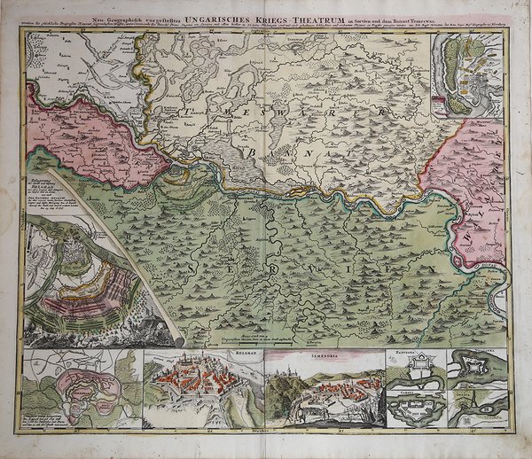
Affascinante mappa storico-geografica che raffigura l'assedio di Belgrado, iniziato nel 1716, nel corso della guerra austro-ungarica-turca, e si concluse il 17 agosto 1717 con la conquista della piazzaforte da parte delle truppe austriache al comando di Eugenio di Savoia. La mappa raffigura il territorio con Belgrado a sinistra, Timi?oara in alto, delimitata a sud dal corso del Danubio. La mappa è arricchita dia9 inserti che compredono le piante della battaglia di Belgrado e di Petrovaradin, e viste a volo d'uccello delle fortificazioni di Timi?oara, Belgrado, Semendria, e altre città. La carta fu realizzata da Homann per il suo Grosser Atlas. Johann Baptist Homann è stato un geografo e cartografo tedesco; nel 1702 fondò la sua casa editrice. Homann acquisì fama come uno dei principali cartografi tedeschi, e nel 1715 fu nominato geografo imperiale dall'imperatore Carlo VI. Nello stesso anno fu anche nominato membro dell'Accademia Prussiana delle Scienze a Berlino. Nel 1716 Homann pubblicò il suo capolavoro Grosser Atlas ueber die ganze Welt. Numerose mappe furono redatte in collaborazione con l'incisore Christoph Weigel. Homann morì a Norimberga nel 1724. Gli successe suo figlio Johann Christoph (1703-1730). L'azienda continuò dopo la sua morte come azienda degli eredi Homann, gestita da Johann Michael Franz e Johann Georg Ebersberger. Dopo successivi cambiamenti nella gestione, l'azienda si sciolse nel 1852. ' Incisione in rame, coloritura coeva in ottime condizioni. Fascinating map depicting the Siege of Belgrade from 1716 to 1717, which occurred during the Austro-Venetian-Ottoman war. The battle ended on August 17, 1717 with Belgrade falling into Austrian control under the command of Prince Eugene of Savoy. The main map depicts the region with Belgrade at left, Temeswar at top, and the Danube River flowing through the center. The map features 9 insets, including the battle plans of the Siege of Belgrade and the Battle of Peterwardein (Petrovaradin), and bird's-eye views of the fortifications of Temeswar, Belgrade, Semendria, and several other towns. The map was made by Homann for his Grosser Atlas. Johann Baptist Homann was a German geographer and cartographer; in 1702 he founded his own publishing house. Homann acquired renown as a leading German cartographer, and in 1715 was appointed Imperial Geographer by Emperor Charles VI. In the same year he was also named a member of the Prussian Academy of Sciences in Berlin. In 1716 Homann published his masterpiece Grosser Atlas ueber die ganze Welt; numerous maps were drawn up in cooperation with the engraver Christoph Weigel the Elder. Homann died in Nuremberg in 1724 and was succeeded by his son Johann Christoph (1703-1730). The company carried on upon his death as Homann heirs company, managed by Johann Michael Franz and Johann Georg Ebersberger. After subsequent changes in management the company folded in 1852. Etching with fine original colour, good condition. Cfr.

 Descubre cómo utilizar
 Descubre cómo utilizar