Nieuwe Paskaart van ‘t Eerste Gedeelte der Middelansche-Zee tusschen ‘t I. Cadix en ‘t I. Malta
Nieuwe Paskaart van ‘t Eerste Gedeelte der Middelansche-Zee tusschen ‘t I. Cadix en ‘t I. Malta | Grabados | VAN KEULEN Gerard
Nieuwe Paskaart van ‘t Eerste Gedeelte der Middelansche-Zee tusschen ‘t I. Cadix en ‘t I. Malta
Nieuwe Paskaart van ‘t Eerste Gedeelte der Middelansche-Zee tusschen ‘t I. Cadix en ‘t I. Malta | Grabados | VAN KEULEN Gerard
Formas de Pago
- PayPal
- Tarjeta de crédito
- Transferencia Bancaria
- Pubblica amministrazione
- Carta del Docente
Detalles
- Año de publicación
- 1743
- Lugar de impresión
- Amsterdam
- Formato
- 1970 X 600
- Grabadores
- VAN KEULEN Gerard
- Descripción
- S. Bifolco, "Mare Nostrum, Cartografia nautica a stampa del Mar Mediterraneo" (2020), pp. 178-179, tav. 79.
Descripción
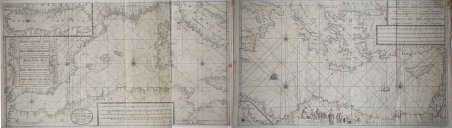
Nieuwe Paskaart van ‘t Eerste Gedeelte der Middelansche-Zee tusschen ‘t I. Cadix en ‘t I. Malta = Nouvelle Carte Marine pour la Premier Partie de la Mer-Mediterranee (.) = The New Sea Map of the First Part of the Midland-Sea (.) = Nueva Carta Maritima la Primera Parte del Mar-Mediteraneo (.) = Nuova Carta Maritima la Prima Parte del Mar- Mediteraneo & Nieuwe Paskaart van ‘t Tweede Gedeelte der Middelandsche-Zee Tusschen ‘t I. Malta en Alexandretta = The New Sea Map of the Seconde Partie of the Midland-Sea (.) = Nouvelle Carte Marine pour la Deuxiesme Partie de la Mer-Mediterranee (.) = Nuova Carta Maritima la Seconda Parte del Mar-Mediteraneo (.).Acquaforte e bulino, stampata su due fogli, rispettivamente di dimensioni 600x990 mm e 595x1000 mm. Rappresentazione nautica del Mar Mediterraneo, suddiviso nella parte occidentale ed in quella orientale.Il titolo della parte occidentale, contenuto nel grande cartiglio decorativo a sinistra, è ripetuto in ben 5 lingue: olandese, francese, inglese, spagnolo e italiano. In basso al centro è riportato l’imprint editoriale: t’ Amsterdam by Ioannes van Keulen Boek Zeeekard Verkooper en Graad boog maker aan de Oost Zyde Vande Nieuwe Brug inde Gekroonde Lootsman met privilegie Nieuwelycks op Gestel door G: v: Keulen. Il titolo della parte orientale, nel grande cartiglio in alto a destra è riportato in 4 lingue ma non in spagnolo. In basso al centro si legge: t’ Amsterdam by Ioannes van Keulen Boek-Zeeekard Verkooper en Graad boog maker aande Oost Zyde van de Nieuwe brug inde Gekroonde Lootsman Opgestelt door G: v: Keulen. met Privilegie.Si tratta di una variante della carta precedente della tipografia Van Keulen - firmata da Johannes I Van Keulen e dal figlio Gerard e databile al 1709 - che vede le lastre emendate e leggermente ridotte (di circa 10 mm): vengono aggiunti degli elementi decorativi nel foglio di destra, dove è disegnato un gruppo di figure in abiti orientali che circonda il cartiglio; nel mare compaiono due navi collocate a largo di Malta e Cipro. Secondo Nils Persson (cfr. Loose printed Sea Charts published by Van Keulen, p. 177) le carte non sono parte di nessuna raccolta nautica, ma venivano vendute singolarmente.Nell’angolo superiore sinistro della tavola occidentale troviamo, fuori scala in un cartiglio, la rappresentazione del Mar Adriatico; nel foglio orientale, in basso a destra, troviamo il particolare della costa libica: Barbaria van I. Zerby tot Tripoli. La prima versione della carta appartiene al terzo volume dello Zee-Fakkel, del quale è una delle tavole aggiunte nel 1709 da Gerard van Keulen. Firmata da Johannes Van Keulen (1654 - 1715), la carta è completata e stampata dal figlio Gerard (1678 - 1726), il cui nome è riportato in entrambi i cartigli. Sebbene, secondo Koeman, la carta sarebbe stampata solo nel 1734 (cfr. AN, IV, p. 341, Keu 95 e V, p. 203), Irene Jacobs conferma che la carta appartiene all’aggiornamento dello Zee-Fakkel del 1709 (cfr. Charts in Zee-Fakkel and Zee-Atlas, p. 204). Il primo atlante Van Keulen nel quale abbiamo riscontrato la presenza della carta è il terzo volume dello Zee-Fakkel, edizione francese del 1723: Le Nouveau & Grand Illuminant Flambeau de la Mer (…) par Nicolas Jansz Vooght, & Gerard van Keulen, Geomêtre, & Maistre en Mathematiques. Imprime a Amsterdam: par Jean Van Ceulen, Marchand Libraire de Cartes Marines. A° 1723. Conservato alla Biblioteca Nacional di Madrid, il volume è citato ma non descritto da Koeman (cfr. AN, IV, p. 345, Keu 103 D). Le raccolte nautiche di Johannes van Keulen non erano composte da carte progettate intenzionalmente per questo tipo di opere: una quarantina di carte furono pubblicate per la prima volta nel 1680, ma il numero delle tavole aumentò sin da subito; nel 1683 - quando furono pubblicate le parti I, II, III, e IV - il numero aumentò a 116 mappe. L’atlante più voluminoso, apparso nel 1695, comprende 160 mappe di Johannes v. Neuwe Paskaart van ‘t Eerste Gedeelte der Middelansche-Zee tusschen ‘t I. Cadix en ‘t I. Malta = Nouvelle Carte Marine pour la Premier Partie de la Mer-Mediterranee (.) = The New Sea Map of the First Part of the Midland-Sea (.) = Nueva Carta Maritima la Primera Parte del Mar-Mediteraneo (.) = Nuova Carta Maritima la Prima Parte del Mar- Mediteraneo & Nieuwe Paskaart van ‘t Tweede Gedeelte der Middelandsche-Zee Tusschen ‘t I. Malta en Alexandretta = The New Sea Map of the Seconde Partie of the Midland-Sea (.) = Nouvelle Carte Marine pour la Deuxiesme Partie de la Mer-Mediterranee (.) = Nuova Carta Maritima la Seconda Parte del Mar-Mediteraneo (.).Etching and engraving, printed on two sheets, respectively 600x900 and 595x1000Nautical representation of the Mediterranean Sea, divided into the western and eastern parts.The title of the western part, contained in the large decorative cartouche on the left, is repeated in 5 languages: Dutch, French, English, Spanish and Italian. At the bottom of the page is the editorial imprint: t 'Amsterdam by Ioannes van Keulen Boek Zeeekard Verkooper en Graad boog maker aan de Oost Zyde Vande Nieuwe Brug inde. The title of the eastern part, in the large cartouche at the top right, is shown in 4 languages but not in Spanish. At the bottom center reads: t 'Amsterdam by Ioannes van Keulen Boek-Zeeekard Verkooper en Graad boog maker aande Oost Zyde van de Nieuwe brug inde Gekroonde Lootsman Opgestelt door G: v: Keulen. met Privileges.It is a variant of the previous map of the Van Keulen's - signed by Johannes I Van Keulen and by his son Gerard and datable to 1709 - which sees the changes and slightly reduced plates (of about 10 mm): decorative elements are added to the sheet on the right, where a group of figures in oriental clothes is drawn surrounding the cartouche; in the sea two ships appear off the coast of Malta and Cyprus. According to Nils Persson (see Loose printed Sea Charts published by Van Keulen, p. 177) the maps are not part of any nautical collection, but were sold individually.In the upper left corner of the western map we find, out of scale in a scroll, the representation of the Adriatic Sea; in the eastern sheet, below on the right, we find the detail of the Libyan coast: Barbaria van I. Zerby tot Tripoli. The first version of the maps belongs to the third volume of the Zee-Fakkel, of which it is one of the tables added in 1709 by Gerard van Keulen. Signed by Johannes Van Keulen (1654 - 1715), the map is completed and printed by his son Gerard (1678 - 1726), whose name is shown in both cartouches. Although, according to Koeman, the map would be printed only in 1734 (see AN, IV, p. 341, Keu 95 and V, p. 203), Irene Jacobs confirms that they belongs to the Zee-Fakkel update of 1709 ( see Charts in Zee-Fakkel and Zee-Atlas, p. 204). The first atlas Van Keulen in which we found the presence of paper is the third volume of the Zee-Fakkel, French edition of 1723: Le Nouveau & Grand Illuminant Flambeau de la Mer (.) par Nicolas Jansz Vooght, & Gerard van Keulen, Geomêtre , & Maistre en Mathematiques. Imprint in Amsterdam: par Jean Van Ceulen, Marchand Libraire de Cartes Marines. A ° 1723. Preserved at the Biblioteca Nacional in Madrid, the volume is quoted but not described by Koeman (see AN, IV, p. 345, Keu 103 D). Johannes van Keulen's nautical collections were published for the first time in 1680, but the number of plates increased immediately; in 1683 - when parts I, II, III, and IV were published - the number increased to 116 maps. The most massive atlas, which appeared in 1695, includes 160 maps by Johannes van Keulen. Later, around 1709, Gerard van Keulen increased the number of plates to 185: the most obsolete ones were replaced by others; the tables were given a new numbering. The book tradition foresaw that a nautical atlas should start with a map of the world; Van Keulen, not being in possession of a copper plate depicting the plani. Cfr. S. Bifolco, "Mare Nostrum, Cartografia nautica a stampa del Mar Mediterraneo" (2020), pp. 178-179, tav. 79.
