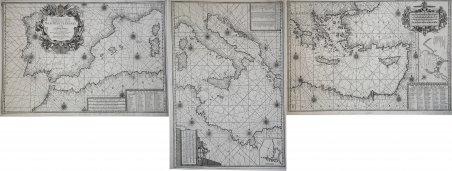
Nouvelle Carte Generalle de la Mer Mediterranée Dediée a Monseigneur Le Grand Prieur General des Galeres de France
Nouvelle Carte Generalle de la Mer Mediterranée Dediée a Monseigneur Le Grand Prieur General des Galeres de France
Formas de Pago
- PayPal
- Tarjeta de crédito
- Transferencia Bancaria
- Pubblica amministrazione
- Carta del Docente
Detalles
- Año de publicación
- 1726
- Lugar de impresión
- Marsiglia
- Formato
- 0 X 0
- Grabadores
- MICHELOT & Laurent BREMOND Henry
- Descripción
- S. Bifolco, "Mare Nostrum, Cartografia nautica a stampa del Mar Mediterraneo" (2020), pp. 260-261, tav. 121.
Descripción
Nouvelle Carte Generalle de la Mer Mediterranée Dediée a Monseigneur Le Grand Prieur General des Galeres de France. Par ses tres humbles Servoteurs Michelot Hidrographe et Pilot Real des Galeres du Roy et Bremond Hidrographe du Roy et de la Ville. Avec Privilege du Roy.Acquaforte, stampata su tre fogli, rispettivamente di dimensioni 499x711 mm, 700x490 mm e 468x693 mm. Imprint editoriale nel cartiglio: Ce Vend chez Laurent Bremond sur le Port a Marseille au Coin de Reboul; in basso a destra, la firma dell’incisore: Gravéè par P. Starckman.Bell'esemplare, in ottimo stato di conservazione.Carta del Mediterraneo, che viene suddiviso in tre parti. Nel foglio occidentale, in basso, un riquadro contiene le scale metriche (ripetute nel foglio centrale, in basso a destra, e in quello orientale, in alto a destra): Echelle de Lieues Françoises et Angloises, a 20 pour Degré; Echelle de Lieues d'Hollande, a 15 pour un Degré; Echelle de Lieues d'Espagne, à 17 1/2 pour un Degré; Echelle de Milles, a 75 pour un Degré, Selon l'usage de la Mediterranée. In basso, in un riquadro, troviamo i Noms des Isles et de quelques Ports contenues dans cette Carte, un elenco di 56 toponimi. Nel foglio centrale, il secondo riquadro riporta i Noms des Isles et de quelques Ports contenues dans cette Carte, lista di ulteriori 64 toponimi; in alto a destra, in un cartiglio, è rappresentato il piano nautico di Tripoli. Nel foglio orientale, un riquadro riporta i Noms des Isles et quelques Caps contenues dans cette Carte, lista di 80 toponimi sul Mar Egeo. La carta è dedicata a Jean Philippe d’Orleans (1702 - 1748), bâtard d’Orléans, chiamato le Chevalier d’Orléans o le Grand Prieur d’Orléans, figlio illegittimo di Filippo d’Orléans, nipote e genero di Luigi XIV. La carta era la seconda tavola dell’atlante nautico che Michelot e Bremond realizzarono nel primo ventennio del Settecento. La tecnica adottata per il disegno costiero e la disposizione dei toponimi provano la derivazione di questa carta direttamente da modelli manoscritti. Il foglio centrale mostra insolitamente il nord a sinistra, a differenza degli altri due fogli, pertanto, sviluppandosi in verticale non è sovrapponibile agli altri due.Henry Michelot, dopo il successo riscosso con la pubblicazione della sua guida nautica Le Portulan de Partie de la Mer Méditerranée, ou Le vray Guide des Pilotes Costiers (1703), cercò di capitalizzarlo unendosi a Laurent Bremond. All’inizio del XVIII secolo Henry Michelot e Laurens Bremond pubblicarono due importanti atlanti nautici del Mediterraneo e piani nautici ampiamente utilizzati dai naviganti costieri. Le carte sono interessanti e importanti per l’attendibilità derivata dall’esperienza di Michelot che, a differenza dei successivi “geografi del Dépôt des cartes et plans de la Marine” come Jacques-Nicolas Bellin ha avuto una lunga esperienza in mare. Il primo atlante prodotto contiene 16 carte, su piccola scala, del Mediterraneo e della costa atlantica in prossimità dello stretto di Gibilterra, integrate da una o più profili costieri. Le date delle carte sono comprese tra il 1715 e il 1726; in questo periodo Michelot si firmava come Hydrographe et Pilote Real des Galères du Roy (idrografo e pilota della cambusa reale per il corpo della galea dei re). Poco si sa del co-creatore dell’opera Laurent Bremond. Nella raccolta nautica il suo nome succede sempre a quello di Michelot, e viene qualificato come Hydrographe du Roy et de la Ville (idrografo del re e della città). Bremond sembrerebbe essere stato l’editore e il venditore della raccolta nautica, la forza commerciale della società; titolare di una sorta di negozio vicino al porto. Tutte le carte sono chiaramente contrassegnate: Ce vendent a Marseille chez Laurens Bremond sur le Port au coin de Reboul (venduto a Marsiglia da Laurens Bremond nel porto all’angolo di Reboul).Bibliografia: National Maritime Museum, Catalogue of the Library - Vol. Three,. Nouvelle Carte Generalle de la Mer Mediterranée Dediée a Monseigneur Le Grand Prieur General des Galeres de France. Par ses tres humbles Servoteurs Michelot Hidrographe et Pilot Real des Galeres du Roy et Bremond Hidrographe du Roy et de la Ville. Avec Privilege du Roy.Etching, printed on three sheets, respectively 499x711 mm, 700x490 mm and 468x693 mm. Imprint in the cartouche: Ce Vend chez Laurent Bremond sur le Port in Marseille au Coin de Reboul; bottom right, the engraver's signature: Gravéè par P. Starckman.Beautiful example, in excellent condition.Mediterranean Sea charts, which is divided into three parts. In the western sheet, at the bottom, a box contains the metric scales (repeated in the central sheet, bottom right, and in the eastern one, top right): Echelle de Lieues Françoises et Angloises, a 20 pour Degré; Echelle de Lieues d'Hollande, a 15 pour un Degré; Echelle de Lieues d'Espagne, à 17 1/2 pour un Degré; Echelle de Milles, a 75 pour un Degré, Selon l'usage de la Mediterranée. Below, in a box, we find the "Noms des Isles and those Ports contenues dues cette Carte", a list of 56 toponyms. In the central sheet, the second box shows the "Noms des Isles and those Ports contenues dans cette Carte", list of further 64 toponyms; in the upper right, in a scroll, the nautical plan of Tripoli is represented. In the eastern folio, a box shows the "Noms des Isles et quelques Caps contenues dans Cette Carte", list of 80 place names on the Aegean Sea. The chart is dedicated to Jean Philippe d’Orleans (1702 - 1748), bâtard d’Orléans, called le Chevalier d’Orléans or le Grand Prieur d’Orléans, illegitimate son of Philip d’Orléans, nephew and son-in-law of Louis XIV.The work was the second plate of the nautical atlas that Michelot and Bremond made in the first twenty years of the eighteenth century. The technique adopted for the coastal design and the placement of toponyms prove the derivation of this chart directly from manuscript models. The central sheet shows unusually the north to the left, unlike the other two sheets, therefore, developing vertically, it cannot be joined on the other two.Henry Michelot, after his success with the publication of his nautical guide "Le Portulan de Partie de la Mer Méditerranée, ou Le vray Guide des Pilotes Costiers" (1703), tried to capitalize it by joining Laurent Bremond. At the beginning of the 18th century, Henry Michelot and Laurens Bremond published two important nautical atlases of the Mediterranean and nautical plans widely used by coastal mariners.The charts are interesting and important for the reliability derived from the experience of Michelot who, unlike the subsequent "geographers of the Dépôt des cartes et de la Marine" like Jacques-Nicolas Bellin had a long experience at sea. The first atlas produced contains 16 maps, on a small scale, of the Mediterranean and the Atlantic coast near the Strait of Gibraltar, supplemented by one or more coastal profiles. The dates of the charts are between 1715 and 1726; in this period Michelot signed himself as Hydrographe et Pilote Real des Galères du Roy (hydrographer and pilot of the royal galley). Little is known about the co-creator of the work Laurent Bremond. In the nautical collection his name always happens to that of Michelot, and he is qualified as Hydrographe du Roy and de la Ville. Bremond seems to have been the publisher and seller of the nautical collection, the commercial strength of the company; owner of a sort of shop near the port. All charts are clearly marked: Ce vendent a Marseille chez Laurens Bremond sur le Port au coin de Reboul (sold in Marseille by Laurens Bremond in the port at the corner of Reboul).Bibliografia: National Maritime Museum, Catalogue of the Library - Vol. Three, Atlas & Cartography, Londra, 1971, pp. 262-263, n. 219 (2-4); R. Shirley, Maps in the Atlases of the British Library, Londra, 2004, pp. 1233-1234, M.MICH-1a. Cfr. S. Bifolco, "Mare Nostrum, Cartografia nautica a stampa del Mar Mediterraneo" (2020), pp. 260-261, tav. 121.