Nova exactissimaque descriptio Danubii
Nova exactissimaque descriptio Danubii
Formas de Pago
- PayPal
- Tarjeta de crédito
- Transferencia Bancaria
- Pubblica amministrazione
- Carta del Docente
Detalles
- Año de publicación
- 1570
- Lugar de impresión
- Anversa
- Formato
- 500 X 340
- Grabadores
- DE JODE Gerard
Descripción
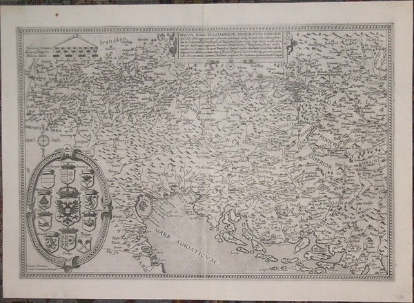
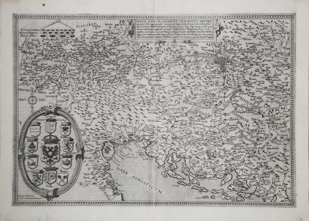
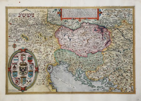
Nova exactissimaque descriptio Danubii (qui alias Ister cognominatur) fluminis permagni totoque terrarum orbe celebratissimi. per Christianum Sgrothonuma.tl Geogrph. Rara carta geografica del corso del Danubio di Gerard de Jode, stampata ad Anversa intorno al 1570 circa. Esemplare tratto dalla seconda edizione dell'atlante del De Jode, curata dal figlio Cornelis e denominata Speculum Orbis Terrae, 1593, con il testo latino al verso e il numero di pagina 27. Il foglio raffigura solo la parte occidentale del corso del Danubio. La carta venne disegnata da Christian Sgrooten ed è incisa dai fratelli Doetecum, la cui firma appare in lastra in basso a sinistra Ioannes a Deutecu, Lucas a Deutecum fecerunt. Il territorio raffigurato è compreso tra le sorgenti del Danubio e la confluenza della Drava nello stesso; include il Friuli, la Slovenia, l’Austria, la Croazia, la Serbia e la Bosnia. Gerard de Jode fu un celebre incisore e stampatore, nativo di Nimega nel 1509. Dopo aver compiuto studî di matematica e di cosmografia, apprese l'arte dell'incisione, fu per qualche tempo alla corte di Carlo V a Bruxelles, poi si trasferì ad Anversa, dove già a partire dal 1551 cominciò a stampare incisioni artistiche di Franz Huys, Martin de Vos, Corneille de Cort, ecc.; ma presto si specializzò nell'incisione di carte geografiche e stampò ad Anversa il celebre mappamondo di Giacomo Gastaldi, nel 1568 l'Italia dello stesso, poi altre carte di molti autori, anche italiani, nel 1564 un grande mappamondo di Abraham Ortelius (Nova totius Terrarum Orbis iuxta neotericorum traditionem descriptio) e infine nel 1578 un vero e proprio atlante con il titolo di ' Speculum Orbis Terrarum, in 65 tavole, di autori diversi, già in parte pubblicate isolatamente. È uno dei primi atlanti moderni (preceduto soltanto dal ' Theatrum ' dell'Ortelius), oggi estremamente raro. Negli ultimi anni della sua vita attendeva a preparare carte dei singoli continenti, di grandi dimensioni, che forse furono poi pubblicate, al pari di un gran mappamondo, dal figlio Cornelio. Questi, nato ad Anversa nel 1568, continuò con molta sagacia l'opera del padre; nel 1589 pubblicò un mappamondo, nel 1593 una nuova edizione dello Speculum, accresciuta, in 109 carte, e nel 1596 una ' Introductio geographica in tabulas Europae, Asiae, Africae et Americae; ' le tavole, cui qui si allude, sono probabilmente quelle preparate dal padre e delle quali il figlio curò la stampa; esse non sono peraltro giunte fino a noi. Cornelio viaggiò poi a lungo nei paesi nordici e anche in Spagna. Ritornando in patria, morì a Mons il 17 ottobre 1600. Acquaforte, finemente colorata a mano, in perfetto stato di conservazione. Bibliografia New Hollstein, Doetecum III, no. 586; Koeman III, 1110; Ortroy S. 126, no. 98: Karrow 70/17, Szathmáry 84/B. ' Nova exactissimaque descriptio Danubii (qui alias Ister cognominatur) fluminis permagni totoque terrarum orbe celebratissimi. per Christianum Sgrothonuma.tl Geogrph. Rare map of the course of the Danube by Gerard de Jode, printed in Antwerp about 1570. Example from the second edition of De Jode's atlas, edited by his son Cornelis and called Speculum Orbis Terrae, 1593. Latin text on verso and page number 27. The sheet depicts only the western part of the Danube's course. The map was drawn by Christian Sgrooten and is engraved by the Doetecum brothers, whose signature appears on the plate at lower left Ioannes a Deutecu, Lucas a Deutecum fecerunt. The territory depicted is between the sources of the Danube and the confluence of the Drava into it; it includes Friuli, Slovenia, Austria, Croatia, Serbia and Bosnia. Gerard de Jode was a celebrated engraver and printer, a native of Nijmegen in 1509. After studying mathematics and cosmography, he learned the art of engraving, was for some time at the court of Charles V in Brussels, then moved to Antwerp, where as early as 1551 he began to print artistic engravings by Franz Huys, Martin de Vos, Corneille de Cort, etc. ; but soon specialized in map engraving and printed in Antwerp the famous world map of Giacomo Gastaldi, in 1568 Italy by the same, then other maps by many authors, including Italians, in 1564 a large world map by Abraham Ortelius (Nova totius Terrarum Orbis iuxta neotericorum traditionem descriptio) and finally in 1578 a full-fledged atlas with the title Speculum Orbis Terrarum, in 65 plates, by different authors, already partly published in isolation. It is one of the earliest modern atlases (preceded only by Ortelius' Theatrum), which is extremely rare today. In the last years of his life he waited to prepare maps of the individual continents, large in size, which were perhaps later published, like a great world map, by his son Cornelius. The latter, born in Antwerp in 1568, continued his father's work with much sagacity; in 1589 he published a world map, in 1593 a new edition of the Speculum, enlarged, in 109 maps, and in 1596 an Introductio geographica in tabulas Europae, Asiae, Africae et Americae; the plates, alluded to here, are probably those prepared by his father and of which his son took care of the printing; they have not, however, come down to us. Cornelius then traveled extensively in the Nordic countries and also in Spain. Returning to his homeland, he died in Mons on October 17, 1600. Etching, finely hand-colored, in perfect condition. Bibliografia New Hollstein, Doetecum III, no. 586; Koeman III, 1110; Ortroy S. 126, no. 98: Karrow 70/17, Szathmáry 84/B. Cfr.