Detalles
Lugar de impresión
Amsterdam
Grabadores
BLAEU Johannes
Descripción
cfr. A. Berkhemer, 'De Spaanse Atlas Mayor van Blaeu: nieuwe gegevens', Caert-Thresoor 16 (1997) 3, pp.71-76, H. De la Fontaine Verwey, The 'Spanish Blaeu,' Quaerendo 11 (1981), pp.83-94.
Descripción
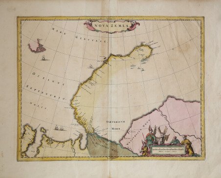
La mappa mostra la Nowaja Semlja (Nova Zembla) nell'Oceano Artico, la penisola Jamal e l'Obbussen.La Novaya Zemlya, nota anche come Nova Zembla, è un arcipelago situato nell'Oceano Artico nel nord della Russia e nell'estremo nord-est dell'Europa, il punto più orientale d'Europa che si trova a Capo Flissingsky, sull'isola settentrionale. A ovest di Novaya Zemlya si trova il Mare di Barents e a est il Mare di Kara. Gli olandesi sono stati i più persistenti ricercatori del cosiddetto "passaggio a nord-est", sia a nord della Novaya Zemlya (la cui costa occidentale è mostrata in dettaglio) sia attraverso quello che a sud hanno chiamato Stretto di Nassau.I russi conoscevano la Novaya Zemlya fin dall'XI secolo, quando i cacciatori di Novgorod visitarono la zona. Per gli europei occidentali, la ricerca della rotta del Mare del Nord nel XVI secolo ha portato alla sua esplorazione. La prima visita di un europeo occidentale fu di Hugh Willoughby nel 1553. L'esploratore olandese Willem Barentsz raggiunse la costa occidentale della Novaya Zemlya nel 1594 e, in una successiva spedizione del 1596, arrotondò il capo settentrionale e svernò sulla costa nord-orientale. Barentsz morì durante la spedizione e potrebbe essere stato sepolto sull'isola di Severny. Durante un successivo viaggio di Fyodor Litke nel 1821? 1824, la costa occidentale fu mappata. Sul grande mappamondo Gerhards Mercator del 1597, è già chiamato Nova Zemla. Henry Hudson era un altro esploratore che passò attraverso Novaya Zemlya mentre cercava il Passaggio a Nord-Est.L'opera appare per la prima volta nell "Atlas Major" di Johannes Blaeu dle 1662. Questo esemplare non ha testo al verso ed è probabilmente pubblicato dai figli di Johannes, dopo la sua morte.Incisione in rame, coloritura coeva, in buono stato di conservazione. Map shows the russian Nowaja Semlja (Nova Zembla) in the Arctic ocean, the peninsula Jamal and the Obbussen, with two decorative cartouches.Novaya Zemlya also known as Nova Zembla is an archipelago in the Arctic Ocean in northern Russia and the extreme northeast of Europe, the easternmost point of Europe lying at Cape Flissingsky on the Northern island. West of Novaya Zemlya is the Barents Sea, and to the east is the Kara Sea. The Dutch were the most persistent searchers after the north-east Passage, whether to the north of Novaya Zemlya (whose west coast is shown in detail) or through what they called Nassau Straits to its south.The Russians knew of Novaya Zemlya from the 11th century, when hunters from Novgorod visited the area. For Western Europeans, the search for the Northern Sea Route in the 16th century led to its exploration. The first visit from a Western European was by Hugh Willoughby in 1553. Dutch explorer Willem Barentsz reached the west coast of Novaya Zemlya in 1594, and in a subsequent expedition of 1596, he rounded the northern cape and wintered on the northeastern coast. Barentsz died during the expedition, and may have been buried on Severny Island. During a later voyage by Fyodor Litke in 1821?1824, the western coast was mapped. On Gerhards Mercator large world map from 1597 , it is alredy named as Nova Zemla. Henry Hudson was another explorer who passed through Novaya Zemlya while searching for the Northeast Passage.The work appears for the first time in Johannes Blaeu's "Atlas Major", 1662. This exemple is without text on verso, and is probably published by Johannes's sons after his death.Copper engraving, iwith fine original colouring, very good condition. Cfr. cfr. A. Berkhemer, 'De Spaanse Atlas Mayor van Blaeu: nieuwe gegevens', Caert-Thresoor 16 (1997) 3, pp.71-76, H. De la Fontaine Verwey, The 'Spanish Blaeu,' Quaerendo 11 (1981), pp.83-94.


 Descubre cómo utilizar
 Descubre cómo utilizar