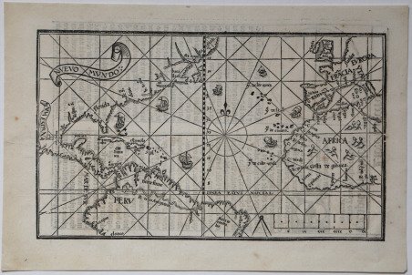
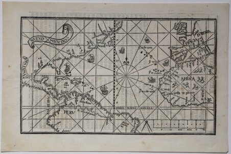
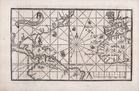
- RARISSIMA PRIMA EDIZIONE – Xilografia, 1545. Esemplare di primo stato, appartenente alla rarissima prima edizione dell’ ' Arte de Navegar ' stampata a Valladolid nel 1545, prima del taglio della lastra e della cancellazione di 8 linee dei radianti. Magnifica prova, impressa su carta vergata coeva, con margini, in perfetto stato di conservazione. Pedro de Medina era un clerico, per un tempo bibliotecario al servizio del Duca di Medina-Sidonia. Nominato cosmografo reale di Spagna, fu incaricato da Carlo V di preparare carte nautiche utili alla navigazione. La sua opera più celebre, ' Arte de Navegar, ' è un testo fondamentale della navigazione del XVI secolo, ed è uno dei tre libri di navigazione che usò Sir Francis Drake per il suo viaggio nel 1554. Il libro ebbe una enorme importanza e fu tradotto in tedesco, francese, inglese ed italiano, in più edizioni dal 1548 al 1568. L’edizione originale di Valladolid del 1545 è di estrema rarità; sul mercato antiquario solo due esemplari risultano venduti negli ultimi 40 anni ed una copia perfetta del libro è stata venduta da Christie’s New York per oltre mezzo milione di dollari. La mappa, unica carta nautica nel libro, talvolta descritta come un mappamondo è in realtà una carta nautica dell’oceano Atlantico, con le coste occidentali dell’Europa e quelle orientali del Nuovo Mondo. Questo primo stato della tavola fu intagliato in un unica matrice di legno, mentre gli esemplari che compaiono nelle successive edizioni dell’opera sono realizzate con l’uso di due matrici lignee. Rappresenta uno dei pochi prodotti della cartografia spagnola del XVI secolo e mostra 16 linee radiali. Le informazioni sul Nuovo Mondo derivano direttamente dal viaggio di Cortes, con il quale il Medina aveva viaggiato. La carta mostra le rotte commerciali e per la prima volta viene rappresentata la linea di demarcazione Papale che divideva l’America in Terra dei Portoghesi, ad Est, e Terra dei Spagnoli, ad Ovest. La mappa venne aggiornata a partire dal 1548, usando una seconda matrice lignea che estendeva la carta a tutto il Sud America. Gli esemplari di primo stato della mappa sono, pertanto, rarissimi. “In 1545 Pedro de Medina published his Art of Navigation which became a fundamental work on the subject. Of interest to us is its map of the Atlantic. His knowledge of the New World was first hand, having travelled with Cortés. Later he held the position of debriefing the returning crews from their voyages. The map depicts the trade routes to and from Spain and her possessions by the use of ships heading south-westerly on the outward bound journey and returning via the Gulf Stream to the north-east. The Papal demarcation line dividing the Americas between Portugal (the land to its east) and Spain (to its west) runs vividly through the map, illustrating for the first time the future influence that the former was to have over the country we know of as Brazil. Central America and particularly the Isthmus of Panama are shown remarkably accurately, and the Yucatan is shown correctly as a peninsula. R. Spu. S. is depicted following Hernando de Soto's epic voyage of exploration through the south, 1539-43. The eastern seaboard is beginning to show some features but they are not easily distinguished. A clearly identifiable Gulf of St. Lawrence begins to take shape following the voyages of Jacques Cartier. The second appearance of this map was in the first edition of Libro de grandezas . de España published in Seville, 1548, with one notable difference. In this edition, and the subsequent one of the same title in 1549 only, there appeared a second woodcut which was printed below the American half of the map and extended its coverage to the Strait of Magellan. To accommodate this the lower border of the left hand side has been removed and is not seen again. There were further editions of the Libro published in Alcalá de Henares, 1566 and 1568, issued without this extension. The map also . - THE FIRST APPEARANCE OF THIS MAP OF THE ATLANTIC AND AMERICAS – VERY RARE first issue of the Medina's map of the New World. Woodcut, perfect condition. Pedro de Medina was a cleric who for a time served as librarian to the Duke of Medina-Sidonia. He was asked to prepare charts and other navigation aids by the emperor Charles V and was named cosmografo de honor in 1549. The ' Arte de navigar ' is the seminal text on navigation in the sixteenth century, and was one of the three books on navigation carried by Drake (in the 1554 French translation). Sometimes described as a world map, it is actually limited to the countries bordering the Atlantic Ocean. The map, one of the few printed in Spain in the sixteenth century, is in its first state, as a single block, with sixteen radiating rhumb lines. Medina's knowledge of the New World was first hand, having traveled with Cortés. Later he held the position of debriefing the returning crews from their voyages" (Burden). The map shows the trade routes to and from Spain. The position of ships on the map indicates the outward south-westerly journey and returning journey via the Gulf Stream to the north-east. For the first time, the Papal demarcation line dividing the Americas between Portugal and Spain is illustrated. Central America and the Isthmus of Panama are very accurately delineated, and the Yucatan is correctly shown as a peninsula. The map was reprinted in the first edition of ' Libro de grandezas. de España ' (Seville, 1548) with the lower half extended to include the Strait of Magellan. The map was later printed in Martin Cortés's Breve compendio of 1551 and Medina's Regimento de navegacion of 1552. The Arte de Navegar was translated into German, French, English and Italian, but the original edition in Spanish is of extreme rarity. According to American Book Prices Current, only two copy appear at auction in the last forty years. The last was sold in Christie’s New York in 2008 for more than half a million . A PERFECT example of this important map. “In 1545 Pedro de Medina published his Art of Navigation which became a fundamental work on the subject. Of interest to us is its map of the Atlantic. His knowledge of the New World was first hand, having travelled with Cortés. Later he held the position of debriefing the returning crews from their voyages. The map depicts the trade routes to and from Spain and her possessions by the use of ships heading south-westerly on the outward bound journey and returning via the Gulf Stream to the north-east. The Papal demarcation line dividing the Americas between Portugal (the land to its east) and Spain (to its west) runs vividly through the map, illustrating for the first time the future influence that the former was to have over the country we know of as Brazil. Central America and particularly the Isthmus of Panama are shown remarkably accurately, and the Yucatan is shown correctly as a peninsula. R. Spu. S. is depicted following Hernando de Soto's epic voyage of exploration through the south, 1539-43. The eastern seaboard is beginning to show some features but they are not easily distinguished. A clearly identifiable Gulf of St. Lawrence begins to take shape following the voyages of Jacques Cartier. The second appearance of this map was in the first edition of Libro de grandezas . de España published in Seville, 1548, with one notable difference. In this edition, and the subsequent one of the same title in 1549 only, there appeared a second woodcut which was printed below the American half of the map and extended its coverage to the Strait of Magellan. To accommodate this the lower border of the left hand side has been removed and is not seen again. There were further editions of the Libro published in Alcalá de Henares, 1566 and 1568, issued without this extension. The map also appeared in Martin Cortes' Breve Compendio of 1551 and 1556, and the Regimiento de navegacion by Medina in 1552 and 1563, all published in Se. Cfr.

 Descubre cómo utilizar
 Descubre cómo utilizar