Paraguay ò Prov. de Rio de La Plata: cum adiacentibus Provinciis
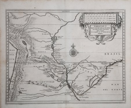
Paraguay ò Prov. de Rio de La Plata: cum adiacentibus Provinciis
Formas de Pago
- PayPal
- Tarjeta de crédito
- Transferencia Bancaria
- Pubblica amministrazione
- Carta del Docente
Detalles
- Año de publicación
- 1625
- Lugar de impresión
- Leida
- Formato
- 360 X 285
- Grabadores
- Laet Johannes de
Descripción
La mappa ricopre il terzo medio del continente sudamericano intorno alla foce del Rio de la Plata e comprende porzioni degli odierni paesi di Perù, Brasile, Paraguay, Uruguay, Cile e Argentina, ma all'epoca della pubblicazione l'area faceva parte delle rivendicazioni coloniali condivise da Portogallo e Spagna. Inomi dei luoghi identificano una varietà di insediamenti coloniali, città indigene, missioni e altro ancora. Le Ande sono rappresentate in modo evidente e denominate lungo il lato sinistro della carta, insieme al Lago Titicaca e ad altre caratteristiche geografiche di rilievo. La mappa fu pubblicata a Leida nel 1630 come parte della Nieuwe Wereldt often Beschrijvinghe van West-Indien (Descrizione delle Indie Occidentali) di Johannes de Laet. L'opera era stata pubblicata originariamente nel 1625 e conteneva dieci mappe; questa è la versione leggermente aggiornata che conteneva quattordici mappe e 100 pagine di testo in più, a testimonianza del crescente interesse degli olandesi per il Nuovo Mondo. Descritte da Philip Burden come "probabilmente la più bella descrizione delle Americhe pubblicata durante il XVII secolo", le mappe dell'opera di de Laet si basavano direttamente sulla cartografia di Hessel Gerritsz, apprendista incisore presso W. J. Blaeu prima di avviare una propria attività. Fu poi nominato cartografo della Compagnia olandese delle Indie orientali e successivamente ricoprì la stessa posizione nella neonata Compagnia delle Indie occidentali. Sebbene Gerritsz abbia effettivamente visitato la zona durante il suo viaggio in Sud America e nelle Indie Occidentali intrapreso nel 1628, questa carta manca ovviamente di conoscenze di prima mano, tranne che lungo la costa. Per la compilazione dei suoi dati geografici Johannes de Laet si avvalse di ricerche meticolose e di fonti contemporanee. In qualità di direttore della neonata Compagnia Olandese delle Indie Occidentali, durante la compilazione delle mappe si è avvalso anche delle informazioni più recenti tratte dalla corrispondenza privata, dai manoscritti e da altri segreti aziendali. La carta di Gerritsz servì da modello per altri cartografi per tutto il resto del secolo. The map covers the middle third of the South American continent around the mouth of the Rio de la Plata and includes portions of the present-day countries of Peru, Brazil, Paraguay, Uruguay, Chile and Argentina, but at the time of publication the area was part of the colonial claims shared by Portugal and Spain. Place names identify a variety of colonial settlements, indigenous towns, missions and more. The Andes are prominently represented and named along the left side of the map, along with Lake Titicaca and other prominent geographical features. The map was published in Leiden in 1630 as part of Johannes de Laet's Nieuwe Wereldt often Beschrijvinghe van West-Indien (Description of the West Indies ). The work was originally published in 1625 and contained ten maps; this is the slightly updated version that contained fourteen maps and 100 more pages of text, reflecting the growing interest of the Dutch in the New World. Described by Philip Burden as "probably the finest description of the Americas published during the seventeenth century," the maps in de Laet's work were based directly on the cartography of Hessel Gerritsz, an engraver's apprentice to W. J. Blaeu before starting his own business. He was then appointed cartographer to the Dutch East India Company and later held the same position in the newly formed West India Company. Although Gerritsz actually visited the area during his trip to South America and the West Indies undertaken in 1628, this map obviously lacks first-hand knowledge, except along the coast. Johannes de Laet used meticulous research and contemporary sources to compile his geographical data. As director of the newly formed Dutch West India Company, he also made use of the latest information from private correspondence, manuscripts, and other company secrets when compiling the maps. Gerritsz' map served as a model for other cartographers throughout the rest of the century. Cfr.