Pas-kaart van Europa met een gedeelte van de kunst van Africa tot aen Cabo verde
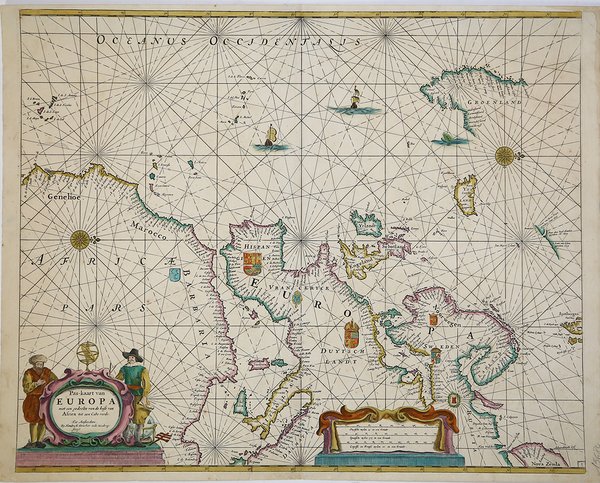
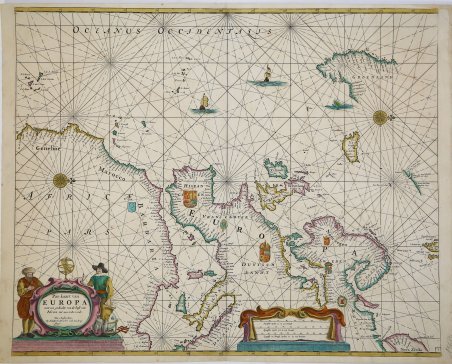
Pas-kaart van Europa met een gedeelte van de kunst van Africa tot aen Cabo verde
Formas de Pago
- PayPal
- Tarjeta de crédito
- Transferencia Bancaria
- Pubblica amministrazione
- Carta del Docente
Detalles
- Año de publicación
- 1705
- Lugar de impresión
- Amsterdam
- Formato
- 520 X 425
- Grabadores
- Donker Hendrick II
- Descripción
- S. Bifolco, "Mare Nostrum, Cartografia nautica a stampa del Mar Mediterraneo" (2020), pp. 164-165, tav. 71.
Descripción
Acquaforte e bulino, 425x520 mm, firmata in lastra nel cartiglio in basso al centro: Tot Amsterdam. By Hendrick Donker inde Nieubrug:steedg.Bellissimo esemplare con magnifica coloritura coeva. Edizione molto rara.Secondo stato della carta nautica basata sul portolano di W. J. Blaeu del 1621, ridotto a formato atlante in-folio, con la data An°. 1665 nel cartiglio che viene abrasa. La mappa è per la prima volta inserita nello Zee-Atlas of Water-Waerelt - una delle quattro carte aggiunte all’originale corpus di 27 tavole nautiche - stampato con imprint t’Amsterdam By Hendrick Donker, Boeckverkooper, en Graat-boog-maker, in de Nieuwe-brug-streegh, in ‘t Stuurmans Gereetschap, Anno 1665. Lo Zee-Atlas of Water-Waerelt viene ristampato in più lingue ed edizioni, ampliate ed aggiornate. La carta dell’Europa rimane inalterata - con la data An°. 1665 - fino al 1705, quando Hendrick Donker jr. la inserisce, cancellando la data, nel De Nieuwe Groote Vermeerdere Zee-Atlas ofte Water-Werelt Vertoonende alle de Zee-Kunsten des Aerdtrycks, Seer dienstigh voor Schippers, Stuur-lieden en Liefhebbers der groote Zee-vaert. Non è chiaro se il figlio Hendrick jr. (1664 -1739 circa) aiutò suo padre nella libreria. Dopo la morte del padre nel 1699, sposò Johanna Maria Blasius e si stabilì nella casa dei suoi genitori. Continuò a pubblicare lo Zeeatlas e lo Zeespiegel fino al 1708 (ultima data che troviamo su un frontespizio). Lo Zee-Atlas of Water-Waerelt (1659) di Hendrick Doncker, tra il 1659 e il 1669, aumentò progressivamente il numero di carte, prima da 19 a 30 e poi a 50. Seguì un’edizione con mappe di grande formato: il Nieuwe Groote Vermeerderde Zeeatlas, anch’esso composto da 50 carte, che venne migliorato e ampliato per oltre 25 anni. Dopo la morte di Hendrick Doncker nel 1699, suo figlio Hendrick jr. continuò la pubblicazione e addirittura ingrandì la raccolta anche con delle carte a latitudine crescente. Bibliografia: C. Koeman, Atlantes Neerlandici: Bibliography of Terrestrial, Maritime and Celestial Atlases and Pilot Books Published in the Netherlands up to 1880 Vol. IV, Amsterdam 1970, pp. 152-189, Don 8A (28), Don 29 (3). Etching and engraving, 425x520 mm, signed in the cartouche center below: Tot Amsterdam. By Hendrick Donker inde Nieubrug: steedg.Beautiful example with magnificent old colouring. Very rare edition.Second state of the nautical chart based on the 1621 W. J. Blaeu’ pilot book, reduced to in folio format; the date An°. 1665 in the cartouche that is abraded.The map is for the first time included in the 1665 edition of the Zee-Atlas of Water-Waerelt - one of the four maps added to the original corpus of 27 nautical tables - printed with imprint t'Amsterdam By Hendrick Donker, Boeckverkooper, en Graat-boog-maker, in de Nieuwe-brug-streegh, in 't Stuurmans GereetschapThe Zee-Atlas of Water-Waerelt was reprinted in many editions and languages, increased and updated. The map of the Europe remains unchanged - with the date An °. 1665 - until 1705, when Hendrick Donker jr. inserts it, deleting the date, in the De Nieuwe Groote Vermeerdere Zee-Atlas ofte Water-Werelt Vertoonende at the de Zee-Kunsten des Aerdtrycks, Seer dienstigh voor Schippers, Stuur-lieden en Liefhebbers der groote Zee-vaert.Bibliografia: C. Koeman, Atlantes Neerlandici: Bibliography of Terrestrial, Maritime and Celestial Atlases and Pilot Books Published in the Netherlands up to 1880 Vol. IV, Amsterdam 1970, pp. 152-189, Don 8A (28), Don 29 (3). Cfr. S. Bifolco, "Mare Nostrum, Cartografia nautica a stampa del Mar Mediterraneo" (2020), pp. 164-165, tav. 71.