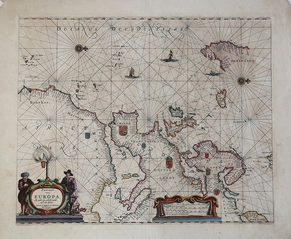
Pascaart van Europa, Als mede een gedeelt vande cust von Africa
Pascaart van Europa, Als mede een gedeelt vande cust von Africa | Grabados | GOOS Pieter

Pascaart van Europa, Als mede een gedeelt vande cust von Africa
Pascaart van Europa, Als mede een gedeelt vande cust von Africa | Grabados | GOOS Pieter
Formas de Pago
- PayPal
- Tarjeta de crédito
- Transferencia Bancaria
- Pubblica amministrazione
- Carta del Docente
Detalles
- Año de publicación
- 1666
- Lugar de impresión
- Amsterdam
- Formato
- 525 X 430
- Grabadores
- GOOS Pieter
- Descripción
- S. Bifolco, "Mare Nostrum, Cartografia nautica a stampa del Mar Mediterraneo" (2020), p. 131, tav. 52.
Descripción
Acquaforte e bulino, 430x525 mm, firmata in lastra nel cartiglio in basso a sinistra: Gedruckt, en uytgegeven tot Amsterdam Bij Pieter Goos.Buona prova, impressa su carta vergata coeva, coloritura coeva con ritocchi, carta leggermente lisa, per il resto in buono stato di conservazione.Opera tratta da: De Zee-Atlas, Ofte Water-Weereld, Waer in vertoont werden alle de Zee-Kunsten Van het bekende des Aerd-Bodems. Seer dienstigh voor alle Schippers en Stuurlidienm Als oock voor alle Heeren en Kooplieden. Gesneden, gedruckt en uytgegeven t’ Amsterdam. By Pieter Goos, op de Texelse Kay, naest de Ramskoy, in de Zee-Spiegel, 1666.La carta ricalca fedelmente il modello di Blaeu del 1621, del quale rappresenta una semplice riduzione al formato in-folio dell’atlante nautico. Bibliografia: C. Koeman, Atlantes Neerlandici: Bibliography of Terrestrial, Maritime and Celestial Atlases and Pilot Books Published in the Netherlands up to 1880 Vol. IV, Amsterdam 1970, pp. 192-217, Goos 1 A-B (2); Mare Nostrum, a historic voyage across the Mediterranean Sea, Lussemburgo, 2003, p. 23; National Maritime Museum, Catalogue of the Library - Vol. Three, Atlas & Cartography, Londra, 1971, p. 83, n. 92 (n. 2); cfr. R. Shirley, Maps in the Atlases of the British Library, Londra, 2004, pp. 1172-1175. Etching and engraving, 430x525 mm, signed lower left, in the cartouche: Gedruckt, en uytgegeven tot Amsterdam Bij Pieter Goos.Good proof, printed on contemporary laid paper, contemporary old colouring, in good condition.Goos' general chart of the Atlantic, Europe and Africa, based upon Blaeu's Paskaert of 1621. From: De Zee-Atlas, Ofte Water-Weereld, Waer in vertoont werden alle de Zee-Kunsten Van het bekende des Aerd-Bodems. Seer dienstigh voor alle Schippers en Stuurlidienm Als oock voor alle Heeren en Kooplieden. Gesneden, gedruckt en uytgegeven t’ Amsterdam. By Pieter Goos, op de Texelse Kay, naest de Ramskoy, in de Zee-Spiegel, 1666.Bibliografia: C. Koeman, Atlantes Neerlandici: Bibliography of Terrestrial, Maritime and Celestial Atlases and Pilot Books Published in the Netherlands up to 1880 Vol. IV, Amsterdam 1970, pp. 192-217, Goos 1 A-B (2); Mare Nostrum, a historic voyage across the Mediterranean Sea, Lussemburgo, 2003, p. 23; National Maritime Museum, Catalogue of the Library - Vol. Three, Atlas & Cartography, Londra, 1971, p. 83, n. 92 (n. 2); cfr. R. Shirley, Maps in the Atlases of the British Library, Londra, 2004, pp. 1172-1175. Cfr. S. Bifolco, "Mare Nostrum, Cartografia nautica a stampa del Mar Mediterraneo" (2020), p. 131, tav. 52.
