Detalles
Lugar de impresión
Anversa
Grabadores
ORTELIUS Abraham
Descripción
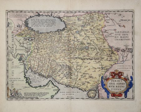
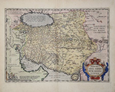
Mappa splendidamente dettagliata della Persia dal Theatrum Orbis Terrarum di Abraham Ortelius, il primo atlante moderno del mondo. Questa mappa si basa in particolare su una mappa dell'Asia Minore di Giacomo Gastaldi del 1564, così come la precedente mappa dell'Asia di Ortelius, datata 1567. Fu stampata in tre stati e apparve negli atlanti dal 1570 fino alla metà del XVII secolo. La mappa mostra il Golfo Persico e la parte orientale della penisola arabica. Al centro c'è quello che oggi è il paese dell'Iran ed è qui la Persia. A est c'è un po' di quello che oggi è l'Afghanistan e il Pakistan e qui è etichettato come parti della Tartaria e dell'India. Il Mar Caspio è in primo piano, ma è mostrato orizzontalmente e in modo indefinito. Carta tratta dal Theatrum Orbis Terrarum e che è considerato il primo vero “atlante” moderno. L’opera fu pubblicata in 7 lingue e 36 edizioni, per il quale – nel 1570 - Ortelius ottenne il privilegio, ovvero una sorta di diritto d'autore che impediva ad altri cartografi di pubblicare i propri lavori. Il Theatrum rappresentava il lavoro più avanzato del lavoro della descrizione cartografica. L’Ortelius vi raccolse il sapere geografico e cartografico del suo tempo, proponendo in 147 spettacolari tavole incise l’immagine più fedele del mondo allora conosciuto e, in alcune straordinarie “carte storiche”, regioni e itinerari tratti dalla letteratura, dalla mitologia, dalla tradizione. Ortelius fu anche il primo a citare le fonti, menzionando i nomi dei cartografi nel “catalogus auctorum”. Dal 1598 al 1612 le edizioni postume del Theatrum furono realizzate dal suo collaboratore Johannes Baptiste Vrients. Incisione in rame, eccellente coloritura coeva, in ottimo stato di conservazione. Highly-influential and beautifully-detailed map of Persia from Abraham Ortelius' ' Theatrum Orbis Terrarum, the first modern atlas of the world. This map draws particularly on a map of Asia Minor by Giacomo Gastaldi from 1564, as well as Ortelius’ earlier map of Asia, dated 1567. It was printed in three states, although the changes between states was minimal, and appeared in atlases from 1570 until the mid-seventeenth century. The map shows the Persian Gulf and the eastern portion of the Arabian Peninsula. At center is what is today the country of Iran and is here Persia. To the east is a bit of what is today Afghanistan and Pakistan and here is labeled as parts of Tartary and India. The land is covered in settlements (marked with a building sign), rivers, and mountain ranges. The Caspian Sea features prominently, yet it is shown horizontally and indefinitely. Map taken from the Theatrum Orbis Terrarum, which is considered the first true modern "Atlas". The work was published in 7 languages and 36 editions, for which - in 1570 - Ortelius obtained the privilege, a kind of copyright that prevented other cartographers from publishing his works. The Theatrum represented the most advanced work of cartographic description. Ortelius collected in it the geographical and cartographic knowledge of his time, proposing in 147 spectacular engraved plates the most faithful image of the world then known and, in some extraordinary "historical maps", regions and routes taken from literature, mythology, tradition. Ortelius was also the first to cite sources, mentioning the names of cartographers in the "catalogus auctorum". From 1598 to 1612 the posthumous editions of the Theatrum were made by his collaborator Johannes Baptiste Vrients. Copper engraving, contemporary coloring, in good condition Cfr.

 Descubre cómo utilizar
 Descubre cómo utilizar