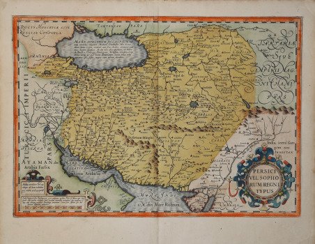
Mappa riccamente dettagliata delle aree dell'attuale Iraq, Iran e Afghanistan, con ricco colore originale, di Jodocus Hondius. Sulla mappa nella zona dell'Iran, Tabriz (Tauris), Teheran (Taron), Isfahan (Ispaham), Qum (Coma) e Shiraz (Schiras) sono tra i molti nomi di luogo riconoscibili; in Iraq compaiono Bagadet (Baghdad), Balsara (Basra), e Mosul, oltre alle rovine di Babilonia. In Afghanistan si trovano Chabul e Candahar. La carta viene preparata da ' Gerard Mercator per l’Atlantis Pars Altera ' (1595) ' pubblicato postumo alla morte dell’autore, sotto la supervisione del figlio Rumold Mercator, dallo stampatore di Duisburg ' Albert Buys. Composto da sei parti – pubblicate separatamente tra il 1589 e il 1594 – comprende 107 mappe, tutte tranne la carta del mondo di Rumold, firmate da Gerard Mercator. Le lastre vennero poi acquistate da Jodocus Hondius, che tra il 1606 e il 1630 le utilizzò per il suo ' Atlas Sive Cosmographicae Meditationes de Fabrica Mundi, integrandole ed aggiornandole con proprie “nuove” carte. Delle mappe di Mercator sono note anche ristampe curate da Johannes Janssonius. Le edizioni Hondius e Janssonius ebbero un grande successo commerciale e furono stampate in più lingue, con il testo al verso della carta in latino, francese, tedesco e olandese. La carta è incisa con i connotati tipici dell'opera mercatoriana. Le montagne sono allineate in un concetto di area montuosa, non per indicare vere catene o valli, ed hanno una struttura con qualche differenza nella dimensione, ma simile per quanto riguarda la forma, con pendici verticali e cime piatte. Le città sono mostrate attraverso castelli più o meno grandi caratterizzati da tetti slanciati ed aguzzi, simili a cappelli di mago. ' Esemplare tratto da ' Atlas Sive Cosmographicae Meditationes de Fabrica Mundi ' di Jodocus Hondius, per la prima volta stampato nel 1606. Incisione in rame, bella coloritura coeva, in buono stato di conservazione. Jodocus Hondius attractive, richly detailed map of the areas of present day Iraq, Iran and Afghanistan, with rich original color. On the map in the area of Iran, Tabriz (Tauris), Tehran (Taron), Isfahan (Ispaham), Qum (Coma) and Shiraz (Schiras) are among the many recognizable place-names; in Iraq, Bagadet (Baghdad), Balsara (Basra), and Mosul appear. The ruins of Babylon are also marked. In Afghanistan, Chabul and Candahar can be found. The map is prepared by Gerard Mercator for his ' Atlantis Pars Altera ' (1595) published posthumously after the death of Mercator, by the Duisburg printer Albert Buys, under the supervision of his son Rumold Mercator. Composed of six parts - published separately between 1589 and 1594 - it includes 107 maps, all except Rumold's map of the world, made by Gerard Mercator. The plates were then purchased by Jodocus Hondius, who between 1606 and 1630 used them for his ' Atlas Sive Cosmographicae Meditationes de Fabrica Mundi, ' integrating and updating them with his own "new" maps. Of Mercator's maps are also known reprints edited by Johannes Janssonius. The Hondius and Janssonius editions had a great commercial success and were printed in several languages, with the text on the back of the map in Latin, French, German and Dutch. The map is engraved with the typical connotations of Mercatorian work. The mountains are aligned in a mountainous area concept, not to indicate true chains or valleys, and have a structure with some differences in size, but similar in shape, with vertical slopes and flat tops. The cities are shown through more or less large castles characterized by slender and pointed roofs, similar to wizard hats. Example from ' Atlas Sive Cosmographicae Meditationes de Fabrica Mundi ' by Jodocus Hondius, first printed in 1606. Copper engraving, in good condition. Cfr.


 Descubre cómo utilizar
 Descubre cómo utilizar