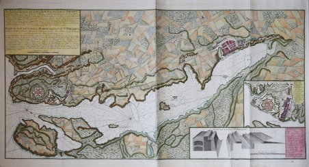
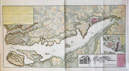
Plan de la Ville et du Port Mahon et du Fort St. Philippe
Plan de la Ville et du Port Mahon et du Fort St. Philippe | Grabados | HOMANN Eredi Johannes Baptiste

Plan de la Ville et du Port Mahon et du Fort St. Philippe
Plan de la Ville et du Port Mahon et du Fort St. Philippe | Grabados | HOMANN Eredi Johannes Baptiste
Formas de Pago
- PayPal
- Tarjeta de crédito
- Transferencia Bancaria
- Pubblica amministrazione
- Carta del Docente
Detalles
- Año de publicación
- 1756
- Lugar de impresión
- Norimberga
- Formato
- 910 X 475
- Grabadores
- HOMANN Eredi Johannes Baptiste
Descripción
La mappa mostra le piante della città di Mahón e della fortezza Castello de San Felipe sull’isola di Minorca. La mappa mostra la pianta del Forte di San Filippo, come veniva chiamato dai francesi, all’epoca in cui fu fortificato dagli spagnoli nel 1706. Il castello fu progettato dall’architetto italiano Giambattista Calvi nel XVI secolo per ordine del re di Spagna e di Aragona Filippo II. Dopo la sua riconquista dagli inglesi nel 1782, il castello fu in gran parte demolito per ordine del re Carlo III. Port Mahón era di particolare importanza strategica durante le guerre del XVIII secolo tra la marina inglese e quella francese nel Mediterraneo. Carta pubblicata a Norimberga dagli eredi Homann. Johann Baptist Homann è stato un geografo e cartografo tedesco; nel 1702 fondò la sua casa editrice. Homann acquisì fama come uno dei principali cartografi tedeschi, e nel 1715 fu nominato geografo imperiale dall'imperatore Carlo VI. Nello stesso anno fu anche nominato membro dell'Accademia Prussiana delle Scienze a Berlino. Nel 1716 Homann pubblicò il suo capolavoro Grosser Atlas ueber die ganze Welt. Numerose mappe furono redatte in collaborazione con l'incisore Christoph Weigel. Homann morì a Norimberga nel 1724. Gli successe suo figlio Johann Christoph (1703-1730). L'azienda continuò dopo la sua morte come azienda degli eredi Homann, gestita da Johann Michael Franz e Johann Georg Ebersberger. Dopo successivi cambiamenti nella gestione, l'azienda si sciolse nel 1852. ' Acquaforte con coloritura coeva e ritocchi, stampata su due fogli, in ottimo stato di conservazione. Map shows plans of the city of Maho?n and the fortress Castillo de San Felipe on the island of Minorca. Inset map shows a plan of Fort St. Philippe, as it was called by the French, at the time when it was fortified by the Spaniards in 1706, and the city wall. The castle was designed by Italian architect Giambattista Calvi in the 16th century at the orders of king of Spain and Aragon, Felipe II. After its recapture from the English in 1782, the castle was mostly demolished on orders of king Carlos III. Port Maho?n was of particularly strategic importance during the eighteenth century wars between the English and French navies in the Mediterranean. Printed on two plates and joined together and published in Nuremberg by Homann Heirs. Johann Baptist Homann was a German geographer and cartographer; in 1702 he founded his own publishing house. Homann acquired renown as a leading German cartographer, and in 1715 was appointed Imperial Geographer by Emperor Charles VI. In the same year he was also named a member of the Prussian Academy of Sciences in Berlin. In 1716 Homann published his masterpiece Grosser Atlas ueber die ganze Welt; numerous maps were drawn up in cooperation with the engraver Christoph Weigel the Elder. Homann died in Nuremberg in 1724 and was succeeded by his son Johann Christoph (1703-1730). The company carried on upon his death as Homann heirs company, managed by Johann Michael Franz and Johann Georg Ebersberger. After subsequent changes in management the company folded in 1852. ' Copperplate with fine original colouring with later addition, printed on 2 sheets, very good condition. Cfr.
