Planisphere Celeste Septentrional
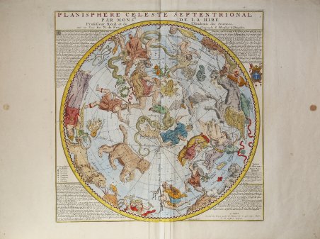
Planisphere Celeste Septentrional
Formas de Pago
- PayPal
- Tarjeta de crédito
- Transferencia Bancaria
- Pubblica amministrazione
- Carta del Docente
Detalles
- Año de publicación
- 1705
- Lugar de impresión
- Parigi
- Formato
- 465 X 475
- Grabadores
- La Hire Gabriel Philippe de
- Materia
- Carte Celesti
Descripción
Carta finemente incisa delle costellazioni dell'emisfero settentrionale, disegnata da Gabriel Phillipe de la Hire, uno dei più noti astronomi francesi e membro della Reale Accademia delle Scienze. Nella tavola è rappresentato entro un cerchio di 42 centimetri di diametro tutto l’emisfero celeste boreale. La proiezione, incentrata sul polo eclittico e avente come circonferenza il cerchio zodiacale dell’Eclittica, è concava quindi le costellazioni appaiono come si vedono nel cielo reale. Il reticolo è formato da raggi di longitudine posti ogni cinque gradi che sono numerati progressivamente ricominciando da capo ogni trenta gradi, le tacche poste sul bordo esterno dell’Eclittica permettono di valutare il singolo grado di longitudine. La latitudine può essere letta tramite dei cerchi posti ogni cinque gradi. L’accorgimento di rappresentare equidistanti i circoli di latitudine permette di vedere le costellazioni che sono lontane dal polo eclittico come appaiono nel cielo reale e quindi non dilatate. Dal Polo equatoriale sono tracciate delle linee di ascensione retta ogni 30 gradi. Oltre al cerchio dell’eclittica è tracciata la linea dell’Equatore, quella del Tropico del Cancro e i due Coluri. Le figure delle costellazioni di La Hire sono influenzate dal grande atlante stellare di Johann Bayer (Uranometria, 1603), sebbene La Hire non abbia utilizzato il sistema di Bayer di numerazione delle stelle in base alla loro luminosità. Nel suo trattato sulle carte celesti, Warner identifica Sir Edmund Halley come una delle fonti principali per il testo delle costellazioni. Figlio di un illustre professore d'arte parigino, Phillipe de la Hire (1640-1718) studiò arte in Italia prima di dedicarsi alla scienza e alla matematica, dove si distinse per la pubblicazione di importanti trattati sulle coniche. La Hire è noto soprattutto per aver disegnato queste carte delle costellazioni dell'emisfero settentrionale e meridionale, pubblicate da Nicolas De Fer, uno dei più importanti editori di mappe francesi. La carta è stata incisa da Hendrick van Loon, responsabile di alcune delle più importanti carte francesi della fine del XVII e dell'inizio del XVIII secolo. ' Tratta da Nicolas De Fer, L'Atlas curieux ou Le Monde représenté dans des cartes générales et particulières du ciel et de la terre, divisé tant en ses quatre principales parties que par etats et provinces et orné par des plans et descriptions des villes capitales et principales et des plus superbes édifices qui les embelissent comme sont les églises, les palais les maisons de plaisance, les jardins, les fontane, Parigi 1702 e 1705. Acquaforte, impressa su carta vergata coeva e finemente colorata a mano, in ottimo stato di conservazione. Bibliografia Warner, p. 145-146. Finely engraved chart of the constellations of the Northern Hemisphere, designed by Gabriel Phillipe de la Hire, one France's most noted astronomers and a member of the Royal Academy of Science. The plate shows within a circle 42 centimeters in diameter the entire boreal celestial hemisphere. The projection, centered on the ecliptic pole and having as its circumference the zodiacal circle of 'Ecliptic, is concave so the constellations appear as they are seen in the real sky. The grid consists of longitude rays placed every five degrees that are numbered progressively starting over every thirty degrees, notches placed on the outer edge of the Ecliptic allow the individual degree of longitude to be estimated. Latitude can be read by circles placed every five degrees. The expedient of representing equidistant circles of latitude makes it possible to see constellations that are far from the ecliptic pole as they appear in the real sky and thus not dilated. Lines of right ascension are drawn from the equatorial pole every 30 degrees. In addition to the circle of the ecliptic, the line of the Equator, that of the Tropic of Cancer and the two Coluries is drawn. La Hire's constellation figures are influenced by Johann Bayer's great star atlas (Uranometria, 1603), although La Hire did not use Bayer's system of number stars based upon their brightness. In his treatise on Celestial maps, Warner identifies Sir Edmund Halley as one of the prime sources for the text surrounding the constellations. The son of a distinguished Paris art professor, Phillipe de la Hire (1640-1718) studied art in Italy before turning to science and mathematics, where he distinguished himself by publishing important treatises on conics. La Hire is best known for his design of charts of the constellations of the Northern and Southern Hemispheres, which were published by Nicolas De Fer, one of France's most important map publishers. The map was engraved by Hendrick van Loon, who was responsible for a number of the most important French maps of the late 17th and early 18th centuries. ' Taken from De Fer L'Atlas curieux ou Le Monde représenté dans des cartes générales et particulières du ciel et de la terre, divisé tant en ses quatre principales parties que par etats et provinces et orné par des plans et descriptions des villes capitales et principales et des plus superbes édifices qui les embelissent comme sont les églises, les palais les maisons de plaisance, les jardins, les fontane, Paris 1702 e 1705. Copperplate with fine later hand colour, good condition. Bibliografia Warner, p. 145-146. Cfr.