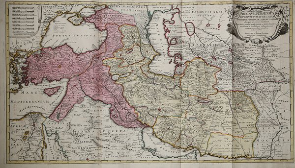
Regnum Persicum Imperium Turcicum in Asia Russorum Provinciae ad Mare Caspium…
Regnum Persicum Imperium Turcicum in Asia Russorum Provinciae ad Mare Caspium…
Formas de Pago
- PayPal
- Tarjeta de crédito
- Transferencia Bancaria
- Pubblica amministrazione
- Carta del Docente
Detalles
- Año de publicación
- 1730
- Lugar de impresión
- Amsterdam
- Formato
- 890 X 520
- Grabadores
- OTTENS Reiner & Joshua
Descripción
Suggestiva mappa dell'Impero Persiano, pubblicata da Reiner e Ottens.La mappa mostra il Regno di Persia, l'Anatolia ottomana, la Russia, il Mar Caspio e i dintorni del Vicino Oriente. Ci sono due colori principali che evidenziano i territori, il giallo è la dinastia Safavide e il rosa è l'Impero ottomano. Le terre nell'angolo sinistro della mappa sono le terre centrali del sud meridionale della Russia. Nell'angolo in basso a sinistra si trova la terra del Regno dei Mongoli.Grandi aree di popolazione sono contrassegnate da stelle rosse come Il Cairo, Costantinopoli e Isfahan, solo Medina non è contrassegnata in rosso. Da questi centri le strade segnalate mostrano le principali rotte commerciali. Catene montuose, laghi rives e mari sono tutti nominati e disegnati.Mappa tratta dall'Atlas minor sive geographia compendiosa in qua orbid terrarum paucis attamen novissimis tablulis ostenditur - Atlas nouveau contenant toutes the party du monde o๠sont exartement remarquées les empires, monarchies, royaumes, états, républiques, & c. Amsterdam, R. & J. Ottens.Incisione su rame, bella coloritura coeva, in ottimo stato di conservazione. Striking map of the the Persian Empire, published by Reiner & Joshua Ottens.The map shows the Kingdom of Persia, Ottoman Anatolia, Russia, the Caspian Sea and the Near Eastern environs, as it was divided in the early 1700s. There are two main colors that highlight territories, yellow being the Safavid Dynasty and the pink being the Ottoman Empire. The lands in the left hand corner of the map outlined in green are the lower south central lands of Russia. On the bottom left hand corner is land of the Kingdom of the Mongols.Large population areas are marked by red stars such as Cairo, Constantinople, and Isfahan, only Medina is not marked in red. From these centers the marked roads show the primary trade routes; these are drawn as two parallel lines going in the same direction. Landmarks such as oasis's and forts and geographical formations are also drawn. Mountain ranges, rives lakes and the seas are all named and drawn.Map taken from Atlas minor sive geographia compendiosa in qua orbid terrarum paucis attamen novissimis tablulis ostenditur - Atlas nouveau contenant toutes les parties du monde o๠sont exactement remarquées les empires, monarchies, royaumes,états, républiques, &c. Amsterdam, R. & J. Ottens (1756).Copper engraving with fine original colouring, very good condition. Cfr.