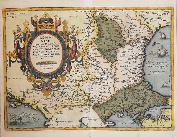
Romaniae, (quae olim Thracia dicta) Vicinarvmq3 Regionvm, vti Bvlgariae, Walachiae, syrfiae, etc. Descriptio
Romaniae, (quae olim Thracia dicta) Vicinarvmq3 Regionvm, vti Bvlgariae, Walachiae, syrfiae, etc. Descriptio
Formas de Pago
- PayPal
- Tarjeta de crédito
- Transferencia Bancaria
- Pubblica amministrazione
- Carta del Docente
Detalles
- Año de publicación
- 1584
- Lugar de impresión
- Anversa
- Formato
- 505 X 370
- Grabadores
- ORTELIUS Abraham
- Descripción
- M. Van den Broecke "Ortelius Atlas Maps" (2011), n. 159.
Descripción
Carta geografica della regione compresa tra Bessarabia, Valachia, Bulgaria, Moldavia, Romania, Dalmazia e Serbia. Dall'edizione spagnola del 1612 del "Theatrum Orbis Terrarum" di Ortelius, il primo Atlante moderno. Basata sulla mappa a due fogli di Jacob Gastaldi dell'area del Danubio nel 1559 e sulla mappa estesa e di quattro fogli dell'Europa sud-orientale del 1560.Incisione in rame, bellissima coloritura coeva,in ottimo stato di conservazione. A nice full color example of Ortelius' map of Romania and contiguous regions west of the Black Sea and north of the Adriatic Coast. Countries located include Bessarabia, Valachia, Bulgaria, Moldova, Syrfia, Romania, Dalmatia and Servia. From the 1612 Spanish edition of Ortelius' Theatrum Orbis Terrarum, the first modern Atlas. Based upon Jacob Gastaldi's two-sheet map of the Danube area in 1559 and extended and four-sheet map of Southeastern Europe in 1560. The ' Theatrum Orbis Terrarum ' is considered the first true modern "Atlas". The work was published in 7 languages and 36 editions, for which - in 1570 - Ortelius obtained the privilege, a kind of copyright that prevented other cartographers from publishing his works. The ' Theatrum ' represented the most advanced work of cartographic description. Ortelius collected in it the geographical and cartographic knowledge of his time, proposing in 147 spectacular engraved plates the most faithful image of the world then known and, in some extraordinary "historical maps", regions and routes taken from literature, mythology, tradition. Ortelius was also the first to cite sources, mentioning the names of cartographers in the "catalogus auctorum". From 1598 to 1612 the posthumous editions of the ' Theatrum ' were made by his collaborator Johannes Baptiste Vrients. Copper engraving, contemporary coloring, in good condition. Cfr. M. Van den Broecke "Ortelius Atlas Maps" (2011), n. 159.