Sicilia Antiqua quae et Trinacria dicta Nummis Siculis illustrata
Sicilia Antiqua quae et Trinacria dicta Nummis Siculis illustrata | Grabados | WEIGEL Christoph
Sicilia Antiqua quae et Trinacria dicta Nummis Siculis illustrata
Sicilia Antiqua quae et Trinacria dicta Nummis Siculis illustrata | Grabados | WEIGEL Christoph
Formas de Pago
- PayPal
- Tarjeta de crédito
- Transferencia Bancaria
- Pubblica amministrazione
- Carta del Docente
Detalles
- Año de publicación
- 1720
- Lugar de impresión
- Norimberga
- Formato
- 415 X 325
- Grabadores
- WEIGEL Christoph
Descripción
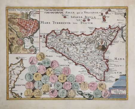
Carta storica della Sicilia basata sul modello di Guillaume De L’Isle del 1714 ed arricchita dallo studio sulle antiche monete dell’isola di Johann David Köhler. “La carta è pubblicata in Descriptio Orbis Antiqui in XLIV Tabulis exhibita a Io. Davode Koelero studio atque opera Christophori Weigelii Norimbergae, 1720. Il volume si compone di 44 carte del mondo antico contornate da monete e figurazioni allegoriche. La Sicilia è la carta numero 19. Per quanto realizzata solo un paio di anni dopo la carta della Sicilia moderna, la Sicilia Antiqua si differenzia notevolmente dalla prima: il contorno e il contenuto geo- grafico non provengono più dalla carta di Homann, ma il modello in generale è nella carta di Delisle del 1714 dalla quale la carta di Köhler riprende i toponimi, le strade e l'inserimento del "Veterum Syracusarum Typus" in un riquadro in alto a sinistra. Ovviamente anche le coordinate sono quelle, utilizzate da Delisle, che fanno riferimento al nuovo meridiano delle Canarie stabilito dalla Academie des Sciences. La carta è ridotta di scala, rispetto a quella di Delisle, per far posto a una vera e propria esposizione di monete dell'antica Sicilia” (cfr. V. Valerio in Sicilia 1477-1861 - La collezione Spagnolo- Patermo, n. 195. Johann David Köhler (18 gennaio 1684 - 10 marzo 1755) è stato uno storico tedesco. I suoi obiettivi accademici erano sulle monete romane come manufatti storici, armi antiche e genealogia. Köhler ha anche lavorato come bibliotecario universitario ad Altdorf e ha contribuito alla prima letteratura bibliografica. Christoph Weigel il Vecchio era un tedesco orafo, incisore, stampante e cartografo tedesco. ' Inizialmente è stato apprendista come incisore nel centro editoriale di Augusta, in seguito al quale ha ricoperto diverse posizioni di Vienna e Francoforte. Nel 1698, è diventato un cittadino della città di Norimberga e ha stabilito lì il proprio studio editoriale. Weigel è noto per aver lavorato a stretto contatto con i più importanti editori di Norimberga: Johann Baptist Homann [1663-1724] e con il fratello, Johann Christoph Weigel [1654 - 1726] e l'accademico tedesco, Johann David Koehler [1684 -1755], il secondo nella pubblicazione di una serie di uscita atlanti scolatici. La sua produzione cartografica include un Atlas Scolasticus [1712], Bequemer Schul und Reisen Atlas (in associazione con Koehler) [1724], e Antiquus Orbis del 1724. Dopo la morte di Weigel nel 1725, la gestione dell'attività passò alla sua vedova, che ha pubblicato postumi molte delle mappe e atlanti del marito. La società passò poi a suo figlio, Johann Christoph Weigel il Giovane [d.1746], che in seguito è entrato in partnership con Adam Gottlieb Schneider, formando la ditta Schneider-Weigel, che ha continuato l'attività editoriale fino al XIX secolo. Acquaforte, finemente colorata a mano, in ottimo stato di conservazione. Bibliografia V. Valerio in Sicilia 1477-1861 - La collezione Spagnolo- Patermo, n. 195. Historical map of Sicily based on Guillaume De L'Isle's 1714 model and enriched by Johann David Köhler's study of the island's ancient coins. "The map is published in Descriptio Orbis Antiqui in XLIV Tabulis exhibita a Io. Davode Koelero studio atque opera Christophori Weigelii Norimbergae, 1720. The volume consists of 44 maps of the ancient world surrounded by coins and allegorical figures. Sicily is chart number 19. Although made only a couple of years after the map of modern Sicily, Sicilia Antiqua differs considerably from the former: the outline and geo-graphic content no longer come from Homann's map, but the model in general is in Delisle's map of 1714 from which Köhler's map takes the place names, roads and the inclusion of the "Veterum Syracusarum Typus" in a box in the upper left corner. Of course, the coordinates are also those, used by Delisle, which refer to the new meridian of the Canary Islands established by the Academie des Sciences. The map is reduced in scale, compared to Delisle's, to make room for a proper display of coins of ancient Sicily" (see V V. Valerio in Sicilia 1477-1861 - La collezione Spagnolo- Patermo, n. 195). Johann David Köhler (January 18, 1684 - March 10, 1755) was a German historian. His academic pursuits were on Roman coins as historical artifacts, ancient weapons and genealogy. Köhler also worked as a university librarian in Altdorf and contributed to the early bibliographical literature. Christoph Weigel the Elder [1654-1725] was a German goldsmith, engraver, printer and mapmaker. He was initially apprenticed as an engraver in the publishing center of Augsburg, after which he held various positions in Vienna and Frankfurt. In 1698, he became a citizen of the city of Nuremberg and established his own publishing firm there. Weigel is known to have worked closely with the most prominent of the Nuremberg map publishers, Johann Baptist Homann [1663-1724] as well as with his brother, Johann Christoph Weigel [1654 - 1726] and the German academic, Johann David Koehler [1684-1755], the latter in the publication of a number of School atlases. His cartographic output included the Atlas Scholasticus [1712], Bequemer Schul und Reisen Atlas (in association with Koehler) [1724], and the Orbis Antiquus 1724. ' Following Weigel's death in 1725, control of the firm passed to his widow, who published many of her late husband's maps and atlases posthumously. The widow Weigel eventually ceded control of the firm to her son, Johann Christoph Weigel the Younger [d.1746], who later went into partnership with Adam Gottlieb Schneider, forming the firm of Schneider-Weigel. Which continued as Nuremberg publishers until the early 19th century. Bibliografia V. Valerio in Sicilia 1477-1861 - La collezione Spagnolo- Patermo, n. 195. Cfr.
