Tabula Aphricae I
Tabula Aphricae I | Grabados | RUSCELLI Girolamo
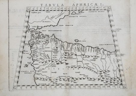

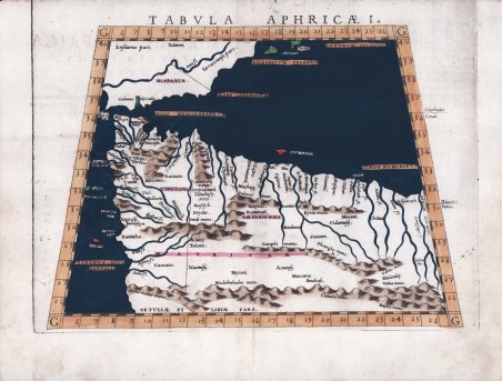
Tabula Aphricae I
Tabula Aphricae I | Grabados | RUSCELLI Girolamo
Formas de Pago
- PayPal
- Tarjeta de crédito
- Transferencia Bancaria
- Pubblica amministrazione
- Carta del Docente
Detalles
- Año de publicación
- 1561
- Lugar de impresión
- Venezia
- Formato
- 261 X 197
- Grabadores
- RUSCELLI Girolamo
- Idiomas
- Italiano
Descripción
Questa mappa di Girolamo Ruscelli si basa sul lavoro di Tolomeo e copre l'Africa nordoccidentale tra cui il Marocco e la Tunisia, la costa contigua della Spagna e le Isole Baleari. All'estremità meridionale della Spagna si trovano le Colonne di Ercole all'estremità orientale dello Stretto di Gibilterra, create, secondo una leggenda, da Ercole quando le raggiunse; viene descritto sulla mappa come Colunna Herculis. È raffigurato gran parte dell'angolo nord-occidentale dell'Africa, inclusa la maggior parte se non tutto il Marocco moderno e gran parte dell'Algeria. Vengono mostrate le grandi montagne dell'Atlante e altre catene montuose insieme a numerosi sistemi fluviali. Le città e i porti noti del giorno sono nominati, così come le isole a ovest del Marocco. Carta tratta dalla ' Geographia di Claudio Tolomeo, a cura di Girolamo Ruscelli, pubblicata in Venezia in più edizioni tra il 1561 ed il 1598. La carta è basata sulla “Geografia” di Giacomo Gastaldi (1548), che probabilmente disegnò personalmente anche queste mappe, che vennero incise dai fratelli Livio e Giulio Sanuto. La peculiarità di queste mappe è che sono incise due per lastra e successivamente tagliate; questo il motivo per cui il segno del rame appare solo in tre lati della mappa. Il testo del Ruscelli e le sue carte sono considerate come il miglior atlante moderno fino alla prima versione del ' Theatrum ' ' Orbis Terrarum ' di Abraham Ortelius (1570). Solo la loro larga diffusione ne impedisce una valutazione sostenuta nel mercato antiquario. L'opera infatti ebbe una prima stesura nel 1561, stampata da Vincenzo Valgrisi che ne curò anche la ristampa del 1562. Tre sono le edizioni firmate da Giordano Ziletti (due nel 1564 e una del 1574), mentre nel 1597 viene edita dai fratelli Calignani. Tutte queste edizioni contengono 64 tavole. Nel 1598 e 1599 vengono alla luce le due edizioni curate da Giuseppe Rosaccio e stampate dagli Eredi di Melchior Sessa. Queste ultime due edizioni comprendono 69 tavole; sono infatti aggiunte la carta del planisfero e dei continenti di Rosaccio. Acquaforte e bulino, finemente colorata a mano, in ottimo stato di conservazione. This Ruscelli map is based on the work of Ptolemy and covers northwestern Africa including Morocco and Tunisia, the contiguous coast of Spain and the Balearic Islands. At the southernmost tip of Spain are the Pillars of Heracles at the eastern end of the Strait of Gibraltar, created, according to one legend by Hercules when he stamped his foot there. It is labeled on the map as Colunna Herculis. Myriad legends abound regarding Hercules and the Pillars. Much of the northwestern corner of Africa is depicted, including most if not all of modern-day Morocco, and much of Algeria. The great Atlas Mountains and other mountain ranges along with numerous rivers systems are shown. Known cities and ports of the day are named, as are islands due west of Morocco. The Atlantic is labeled in Latin ‘Oceanus Occidentalis’, meaning the Western Ocean. ' Map taken from ' Geographia di Claudio Tolomeo ' edited by Girolamo Ruscelli, published in Venice in several editions between 1561 and 1598. The maps is based on the ' Geografia ' by Giacomo Gastaldi (1548), who probably also personally drew these maps, which were engraved by the brothers Livio and Giulio Sanuto. The peculiarity of these maps is that they are engraved two for plate and subsequently cut; this is why the copper sign only appears on three sides of the map. Ruscelli's text and his maps are considered to be the best modern atlas up to the first version of Abraham Ortelius' ' Theatrum Orbis Terrarum ' (1570). Only their widespread diffusion prevents a sustained evaluation in the antiquarian market. In fact, the work had a first edition in 1561, printed by Vincenzo Valgrisi who also edited the 1562 reprint. There are three editions signed by Giordano Ziletti (two in 1564 and one in 1574), while in 1597 it was published by the Calignani brothers. All these editions contain 64 plates. In 1598 and 1599 the two editions edited by Giuseppe Rosaccio and printed by the heirs of Melchior Sessa came to light. These last two editions include 69 plates; in fact, Rosaccio's map of the planisphere and continents has been added. Etching and engraving with fine later hand colour, in good condition. Cfr.
