Detalles
Lugar de impresión
Basilea
Grabadores
Münster Sebastian
Descripción
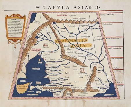
Raffigura parte dell'Ucraina e le repubbliche Caucasiche che affacciano sul Mar Nero e Mar Caspio. Carta a proiezione trapezoidale tratta dal ' Rerum Geographicarum ' dello Strabo, edizione stampata a ' Basileae: Ex Officina Henricpetriana, 1571 Mense Augusto. L'opera è illustrata dalle tavole di Sebastian Münster (1488-1552), per la prima volta apparse nella sua ' Geographia ' di Tolomeo del 1540, che sono parzialmente corrette nei testi. Il ' Rerum Geographicarum ' del 1571 è la prima edizione dell’opera con il commento e della traduzione latina dell'umanista e filologo tedesco Guilielmus Xylander, noto anche come Wilhelm Holtzman. Contiene 27 carte realizzate con le tavole originali per la prima vota pubblicate dall’editore Heinrich Petri nel 1540, debitamente emendate nei testi. Strabone (lat. Strabo) era uno storico e geografo greco, nato ad Amasia, città del Ponto, poco prima del 60 a. C. La sua opera principale è la ' Geografia. Essa pare fosse in sostanza compiuta nel 7 a. C. e l'autore vi avrebbe fatto in seguito solo poche aggiunte e apportato qualche aggiornamento; così si spiegherebbe il silenzio sugli avvenimenti posteriori al 7 a. C. e nello stesso tempo i rari accenni a fatti del 18 d. C. e di qualche anno dopo. L'opera è un vasto trattato generale di geografia. A differenza della geografia tolemaica, improntata su uno studio ed una analisi più rigidamente matematiche, la ' Geografia ' di Strabone presenta un impianto più storico-antropologico risultando il più importante autore di questo filone. La sua grande fortuna cominciò con il sec. VI e durò sino all'età moderna. Silografia, bella coloritura a mano, in ottime condizioni. The map shows of part of the Ukraine and the region between the Black Sea and Caspian Sea extending south to include all of Armenia Maior and part of Armenia Minoris. Trapezoidal projection map from Strabo's ' Rerum Geographicarum, edition printed in ' Basileae: Ex Officina Henricpetriana, 1571 Mense Augusto. The work is illustrated by the maps of Sebastian Münster (1488-1552), which first appeared in his 1540 ' Geographia ' of Ptolemy, and which are partially corrected in the texts. The 1571 ' Rerum Geographicarum ' is the first edition of the work with commentary and Latin translation by the German humanist and philologist Guilielmus Xylander, also known as Wilhelm Holtzman. It contains 27 maps made from the original woodblocks, first published by Heinrich Petri in 1540, duly amended in the texts. Strabo (lat. Strabo) was a Greek historian and geographer, born in Amasia, a city in Pontus, shortly before 60 BCE. His main work is the ' Geography. It seems that it was essentially completed in 7 BC and the author would have done later only a few additions and made some updates, so it would explain the silence on events after 7 BC and at the same time the rare mention of events of 18 AD and a few years later. The work is a vast general treatise on geography. Unlike the Ptolemaic geography, based on a study and analysis more rigidly mathematical, ' Geography ' Strabo presents a more historical and anthropological resulting in the most important author of this strand. His great fortune began with the sec. VI and lasted until the modern age. Woodcut, beautiful hand-coloring, in very good condition. Cfr.


 Descubre cómo utilizar
 Descubre cómo utilizar