Tabula Hispaniae Intra promontorium S. Vincenty et premontorium Bagador, ut et Canarie insulae
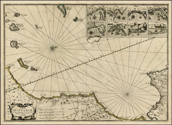
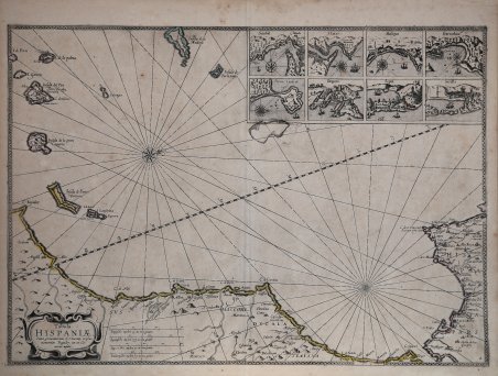
Tabula Hispaniae Intra promontorium S. Vincenty et premontorium Bagador, ut et Canarie insulae
Formas de Pago
- PayPal
- Tarjeta de crédito
- Transferencia Bancaria
- Pubblica amministrazione
- Carta del Docente
Detalles
- Año de publicación
- 1654
- Lugar de impresión
- Amsterdam
- Formato
- 540 X 390
- Grabadores
- BARENTSZ & Johannes JANSSONIUS Willem
Descripción
Bell'esemplare dell'edizione Janssonius della carta marittima di Barentsz delle Isole Canarie, di Madeira, della costa sud-occidentale della Spagna e delle coste contigue del Marocco. La tavola è inserita nel rarissimo Descriptio Maris Mediterranei (1654) di Janssonius; Koeman cita solo 4 esemplari completi di questa raccolta. La Descriptio Maris Mediterranei contiene 10 tavole, su complessive 26, realizzate mediante l’aggiornamento delle carte nautiche preparate da Willem Barentsz per il Caertboeck vande Midlandtsche Zee, pubblicato da Cornelis Claesz nel 1595. Alla morte di Claesz (1609) le matrici della tipografia vennero vendute in asta, dove furono probabilmente acquistate da Pieter van den Keere, che proprio in quell’anno avviava la sua carriera editoriale. In virtù dei loro legami di parentela, tramite la famiglia Hondius, le lastre giunsero a Johannes Janssonius, che curò una ristampa dell’atlante nautico già nel 1626 - la Description de la Mer Mediterranee, auquel sont deliniees et descriptes au vif toutes les costes de la Mer Mediterraine - che non presentava alcun aggiornamento delle tavole nautiche. In questa nuova edizione, dal titolo in latino Descriptio Maris Mediterranei, le 10 tavole di Barentsz furono notevolmente rilavorate, secondo un gusto più moderno, e aggiornate; furono abrasi i nomi di Barentsz e Plancius. Willem Barentsz (1550 - 1597), cartografo ed esploratore olandese, fu uno dei grandi pionieri dell’esplorazione dell’Artico. Il suo primo lavoro importante fu il Caertboeck vande Midlandtsche Zee, il primo atlante nautico dedicato al Mediterraneo, che pubblicò insieme a Petrus Plancius. Barentsz, tuttavia, viene ricordato soprattutto per le sue esplorazioni artiche. Nel 1553 - 1554, gli avventurieri inglesi Sir Hugh Willoughby e Richard Chancellor avevano tentato di trovare una rotta per l’Asia attraverso la Siberia. Mentre la loro missione si rivelò fallimentare, i resoconti del viaggio convinsero molti ad Amsterdam dell’esistenza di un passaggio a nord-est. Barentsz guidò tre spedizioni di ricercar: il primo viaggio, nel giugno del 1594, partì da Texel per il mare di Kara. Le navi raggiunsero la costa di Novaya Zemlya e la seguirono verso nord ma, alla fine, furono costretti a tornare indietro. Anche la seconda spedizione (1595), finanziata dal principe Maurizio di Orange, si rilevò infruttuosa, a causa del Mare di Kara insolitamente ghiacciato. La terza spedizione del 1596 fu l’ultimo tentativo di rivendicare il premio offerto per la scoperta del passaggio da parte degli Stati Generali olandesi. La spedizione scoprì Spitsbergen nell’arcipelago delle Svalbard, e, alla fine, raggiunse la Novaya Zembla il 17 luglio. La nave di Barentsz fu, quindi, bloccata dal ghiaccio e poco dopo Barentsz perse la vita. Una delle navi tornò ad Amsterdam nel novembre del 1597; diversi membri dell’equipaggio scrissero resoconti del viaggio. Nel 1871 il capitano norvegese Carlsen trovò i resti diroccati della casa che Barentsz si era costruito come stazione di sverno nella Novaja Zemlja e trasportò con se le preziose e, in gran parte intatte, reliquie che ora si conservano Museo della Marina dell’Aia. Il nome di Mare di Barentsz è rimasto alla parte del Mar Glaciale, insinuata fra la costa settentrionale europea, la Novaja Zemlja, la Terra di Francesco Giuseppe e le Svalbard, mentre Isola di Barentsz si chiama una tra le isole orientali delle Svalbard. ' Jan Janssonius (1588 - 1664) - noto anche come Johann o Jan Jansson o Janszoon - era un importante geografo ed editore del diciassettesimo secolo, il periodo in cui gli olandesi dominavano la pubblicazione di mappe in Europa. Nato ad Arnhem, Jan fu educato al commercio librario tramite suo padre, anch’egli libraio ed editore. Nel 1612 si sposò con Elisabeth de Hondt, la figlia di Jodocus Hondius, uno dei più grandi creatori di mappe di Amsterdam. Pubblicò le sue prime mappe di Francia e Italia nel 1616. Nel 1623 Jan. Nice example of the Janssonius edition of Barentsz sea chart of the Canary Islands, Madeira, the southwest coast of Spain and contiguous coastline of Morocco, which appeared in Jansson's Descriptio Maris Mediterranei, per tabula hydographics & geographicas . . ., published in Amsterdam in 1654. The map is a later re-issue of Barentsz map, with Jansson having completely changed the title and reworked the decorative embellishments, removing many of the great images originally added by Barentsz. Willem Barentsz (1550 - 1597), Dutch cartographer and explorer, was one of the great pioneers of Arctic exploration. His first major work was the Caertboeck vande Midlandtsche Zee, the first nautical atlas devoted to the Mediterranean, which he published together with Petrus Plancius. Barentsz, however, is best remembered for his Arctic explorations. In 1553 - 1554, English adventurers Sir Hugh Willoughby and Richard Chancellor had attempted to find a route to Asia through Siberia. While their mission proved unsuccessful, accounts of the journey convinced many in Amsterdam of the existence of a passage to the northeast. Barentsz led three research expeditions: the first voyage, in June 1594, left Texel for the Kara Sea. The ships reached the coast of Novaya Zemlya and followed it northward but were eventually forced to turn back. The second expedition (1595), financed by Prince Maurice of Orange, also proved unsuccessful because of the unusually frozen Kara Sea. The third expedition in 1596 was the last attempt to claim the prize offered for the discovery of the passage by the Dutch States-General. The expedition discovered Spitsbergen in the Svalbard archipelago, and eventually reached Novaya Zembla on July 17. Barentsz's ship was, then, blocked by ice, and shortly afterward Barentsz lost his life. One of the ships returned to Amsterdam in November 1597; several crew members wrote accounts of the voyage. In 1871 Norwegian Captain Carlsen found the crumbling remains of the house that Barentsz had built for himself as a wintering station in Novaja Zemlja and transported with him the precious and, largely intact, relics that are now preserved Navy Museum in The Hague. The name Barentsz Sea has stuck to the part of the Ice Sea insinuated between the northern European coast, Novaja Zemlja, Franz Joseph Land and Svalbard, while Barentsz Island is called one among the eastern islands of Svalbard. Jan Janssonius (also known as Johann or Jan Jansson or Janszoon) (1588-1664) was a renowned geographer and publisher of the seventeenth century, when the Dutch dominated map publishing in Europe. Born in Arnhem, Jan was first exposed to the trade via his father, who was also a bookseller and publisher. In 1612, Jan married the daughter of Jodocus Hondius, who was also a prominent mapmaker and seller. Jonssonius’ first maps date from 1616. In the 1630s, Janssonius worked with his brother-in-law, Henricus Hondius. Their most successful venture was to reissue the Mercator-Hondius atlas. Jodocus Hondius had acquired the plates to the Mercator atlas, first published in 1595, and added 36 additional maps. After Hondius died in 1612, Henricus took over publication; Janssonius joined the venture in 1633. Eventually, the atlas was renamed the ' Atlas Novus ' and then the ' Atlas Major, ' by which time it had expanded to eleven volumes. Janssonius is also well known for his volume of English county maps, published in 1646. Janssonius died in Amsterdam in 1664. His son-in-law, Johannes van Waesbergen, took over his business. Eventually, many of Janssonius’ plates were sold to Gerard Valck and Pieter Schenk, who added their names and continued to reissue the maps. ' Bibliografia G. Schilder, Monumenta Cartographica Neerlandica, Vol. VII, Alphen aan den Rijn, 2003, pp. 133-144; G. Schilder, Early Dutch Maritime Cartography. The North Holland School of Cartography (c. 1580-1620), Leida-Boston, 2017, pp. 197-213, ill. 6.17. ' Cfr.