Tabula Itineris decies mille Graecorum sub Cyro contra fratem suum Artaxerxem Regem Persarum, …
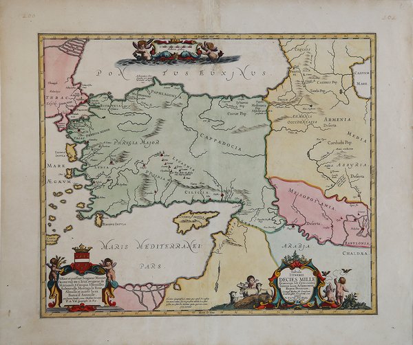

Tabula Itineris decies mille Graecorum sub Cyro contra fratem suum Artaxerxem Regem Persarum, …
Formas de Pago
- PayPal
- Tarjeta de crédito
- Transferencia Bancaria
- Pubblica amministrazione
- Carta del Docente
Detalles
- Año de publicación
- 1653
- Lugar de impresión
- Amsterdam
- Formato
- 495 X 420
- Grabadores
- JANSSONIUS Johannes
- Descripción
- Koeman, C. Atlantes Neerlandici, Ja 2.
Descripción
Bella carta storico-geografica che riporta il percorso dei Diecimila secondo l’Anabasi di Senofonte, ovvero la marcia da Sardi a Cunassa, e il ritorno da Cunassa in Grecia, dei mercenari greci assoldati da Ciro il giovane per usurpare il trono di Persia al fratello Artaserse.Senofonte era uno dei Diecimila.La battaglia tra i due esericti fu combattuta a Cunassa, nel 401 a.C.Anche se l'armata dei mercenari fu vittoriosa nella battaglia sostenuta a Cunassa contro l'esercito dell'imperatore, Ciro non sopravvisse allo scontro, e la sua morte privò la spedizione di ogni senso: i Greci, penetrati troppo a fondo nel territorio nemico, dovettero così ritirarsi verso un porto sicuro, in un ripiegamento che si preannunciava lunghissimo e pieno di insidie.Esemplare tratto da Accuratissima Orbis antiqui delineatio . L'atlante del Mondo Antico di J. Janssonius, che ebbe diverse edizioni dal 1652 al 1741. Joannes Janssonius, figlio dell'editore di Arnhem Jan Janssen, sposò Elisabeth Hondius, figlia di Jodocus Hondius, ad Amsterdam nel 1612. Dopo il suo matrimonio, si stabilì in questa città come libraio ed editore di materiale cartografico. Nel 1618 si stabilì ad Amsterdam accanto alla libreria di Willem Jansz. Blaeu, entrando in una seria competizione. Le sue attività non riguardavano solo la pubblicazione di atlanti e libri, ma anche di mappe singole e un vasto commercio di libri con filiali a Francoforte, Danzica, Stoccolma, Copenaghen, Berlino, Koningsbergen, Ginevra e Lione. Nel 1631 iniziò a pubblicare atlanti insieme a Henricus Hondius. Nei primi anni 1640 Henricus Hondius lasciò l'attività di pubblicazione di atlanti completamente a Janssonius. La concorrenza con Joan Blaeu, figlio e successore di Willem, nella produzione di atlanti spinse Janssonius ad ampliare il suo Atlas Novus finalmente in un'opera di sei volumi, in cui furono inseriti un atlante marino e un atlante del Vecchio Mondo. Dopo la morte di Joannes Janssonius, il negozio e la casa editrice furono continuati dagli eredi sotto la direzione di Johannes van Waesbergen (c. 1616-1681), genero di Joannes Janssonius. Le matrici degli atlanti di Janssonius furono in seguito vendute a Schenk e Valck. Acquaforte, impressa su carta vergata coeva, finemente acquarellata, in ottimo stato di conservazione. A map of Persia, indicating major settlements, regions, and mountain ranges, as well as the march of the Ten Thousand . The Ten Thousand were a group of mercenary units, mainly Greek, drawn up by Cyrus the Younger to attempt to wrest the throne of the Persian Empire from his brother, Artaxerxes II. Their march to the Battle of Cunaxa and back to Greece (401 BC-399 BC) was recorded by Xenophon (one of its leaders) in his work, The Anabasis. This map was compliled by the French cartographer Pierre du Val, and published in Jansson's Atlas of the Antique World , Accuratissima Orbis antiqui delineatio. which went through several editions 1652-1741. Joannes Janssonius (Arnhem, 1588-1664), son of the Arnhem publisher Jan Janssen, married Elisabeth Hondius, daughter of Jodocus Hondius, in Amsterdam in 1612. After his marriage, he settled down in this town as a bookseller and publisher of cartographic material. In 1618 he established himself in Amsterdam next door to Blaeu’s book shop. He entered into serious competition with Willem Jansz. Blaeu. His activities not only concerned the publication of atlases and books, but also of single maps and an extensive book trade with branches in Frankfurt, Danzig, Stockholm, Copenhagen, Berlin, Koningsbergen, Geneva, and Lyon. In 1631 he began publishing atlases together with Henricus Hondius. In the early 1640s Henricus Hondius left the atlas publishing business completely to Janssonius. Competition with Joan Blaeu, Willem’s son and successor, in atlas production prompted Janssonius to enlarge his Atlas Novus finally into a work of six volumes, into which a sea atlas and an atlas of the Old World were inserted. After the death of Joannes Janssonius, the shop and publishing firm were continued by the heirs under the direction of Johannes van Waesbergen (c. 1616-1681), son-in-law of Joannes Janssonius. The copperplates from Janssonius’s atlases were afterwards sold to Schenk and Valck. Cfr. Koeman, C. Atlantes Neerlandici, Ja 2.