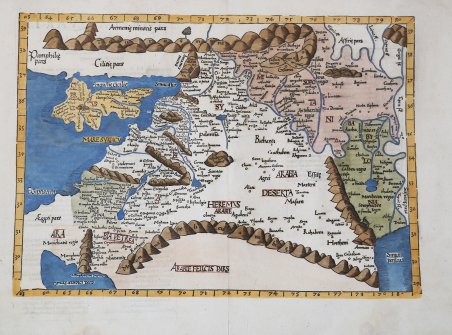
Tabula quarta Asiae complectitur Cyprum insulam, Syriam, Phoniceam, Iudaedam Palestinam, Arabiam Petream.
Tabula quarta Asiae complectitur Cyprum insulam, Syriam, Phoniceam, Iudaedam Palestinam, Arabiam Petream. | Grabados | FRIES Laurent


Tabula quarta Asiae complectitur Cyprum insulam, Syriam, Phoniceam, Iudaedam Palestinam, Arabiam Petream.
Tabula quarta Asiae complectitur Cyprum insulam, Syriam, Phoniceam, Iudaedam Palestinam, Arabiam Petream. | Grabados | FRIES Laurent
Formas de Pago
- PayPal
- Tarjeta de crédito
- Transferencia Bancaria
- Pubblica amministrazione
- Carta del Docente
Detalles
- Año de publicación
- 1522
- Lugar de impresión
- Vienne
- Formato
- 520 X 395
- Grabadores
- FRIES Laurent
Descripción
Mappa che illustra la concezione tolemaica del Medio Oriente, compreso tra il Mediterraneo, il Mar Rosso e il Golfo Persico, che si estende da Cipro a Babilonia. Fiumi, nomi di luoghi e montagne a forma di corda riempiono la mappa. La carta è ridotta da quella di Martin Waldseemuller del 1513, con alcune modifiche, tra cui la riduzione delle dimensioni della baia a nord di Jaffa (qui ioppe). Il titolo è sul verso insieme al testo latino. Il presente esemplare è tratto dall'edizione del 1541 della Geographia di Tolomeo curata da Fries. La prima edizione della "Geographia" di Tolomeo curata da Fries fu pubblicata a Strasburgo nel 1522, con le carte che furono copiate e nuovamente incise da quelle di Martin Waldseemüller dell'edizione di Tolomeo del 1520 e testo a cura di Pirckheimer. Nel 1525 viene stampata una seconda edizione a Strasburgo. Alla scomparsa del Fries e del Gruninger, le matrici furono acquistate dai fratelli Melchior e Gaspar Treschel che ne stampano una terza edizione a Lione nel 1535. Per il testo i due editori si servirono della supervisione di Michael Servetus, che curò la revisione del testo del Pirckheimer. Infine, nel 1541, Gaspare Treechsel pubblica a Vienne, nel Delfinato, questa quarta edizione, sempre con testo di Servetus. In questa edizione, rispetto alla prima di Strasburgo del 1522, il testo subì numerose modifiche, correzioni e aggiunte, ma i legni non furono modificati. Xilografia, finemente colorata a mano, piccolo restauro nella piega centrale e negli angoli inferiori del margine bianco perfettamente eseguito, per il resto in ottimo stato di conservazione. Bibliografia Laor #613; Mickwitz & Miekkavaara #211-18; Zacharakis #1829. Woodblock map illustrating the Ptolemaic concept of the Middle East, between the Mediterranean, the Red Sea and the Persian Gulf, extending from Cyprus to Babylonia. Rivers, place names, and rope-like mountains fill the map. The map is reduced from Martin Waldseemuller's map, with a few changes, including a reduction in size of the bay north of Jaffa (here ' ioppe). Title is on the verso along with Latin text. The first edition of Ptolemy's Geographia edited by Fries was published in Strasbourg in 1522, with maps that were copied and re-engraved from those of Martin Waldseemüller of the 1520 edition of Ptolemy and text edited by Pirckheimer. In 1525 a second edition was printed in Strasbourg. At the death of Fries and Gruninger, the plates were purchased by the brothers Melchior and Gaspar Treschel, who printed a third edition in Lyon in 1535. For the text, the two editors used the supervision of Michael Servetus, who edited Pirckheimer's text. Finally, in 1541, Gaspare Treechsel published in Vienne, in the Dauphiné, this fourth edition, again with Servetus' text. In this edition, compared to the first edition of Strasbourg in 1522, the text underwent numerous changes, corrections and additions, but the wood-blocks were not changed. ' Woodcut, finely colored by hand, in excellent condition. From the 1541 edition of Fries Geographia. Bibliografia Laor #613; Mickwitz & Miekkavaara #211-18; Zacharakis #1829. Cfr.
