Detalles
Lugar de impresión
Venezia
Grabadores
RUSCELLI Girolamo
Descripción
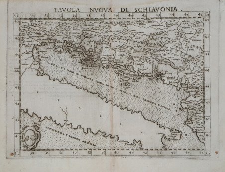
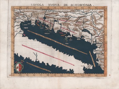
Mappa della Dalmazia basata sulle opera di Claudio Tolomeo; ricopre l'intera lunghezza della costa adriatica orientale e l'entroterra fino al Danubio a est e alla Drava a nord. I problemi classici degli adattamenti di Tolomeo sono ancora evidenti, come i rilievi che sono stati mostrati in modo relativamente arbitrario. La rete fluviale è appena riconoscibile, così come le linee di terra costiera. La rappresentazione delle montagne dinariche centrali dal modello di Tolomeo è qui particolarmente enfatizzata. Vengono mostrate anche alcune isole del Mare Adriatico. I mari sono punteggiati e la mappa è impreziosita da uno stemma nell'angolo in basso a sinistra; stemma di Ragusa (Dubrovnik), una delle più importanti repubbliche marinare dell'epoca. Carta tratta dalla Geographia di Claudio Tolomeo, a cura di Girolamo Ruscelli, pubblicata in Venezia in più edizioni tra il 1561 ed il 1598. La carta è basata sulla “Geografia” di Giacomo Gastaldi (1548), che probabilmente disegnò personalmente anche queste mappe, che vennero incise dai fratelli Livio e Giulio Sanuto. La peculiarità di queste mappe è che sono incise due per lastra e successivamente tagliate; questo il motivo per cui il segno del rame appare solo in tre lati della mappa. Il testo del Ruscelli e le sue carte sono considerate come il miglior atlante moderno fino alla prima versione del Theatrum ' Orbis Terrarum di Abraham Ortelius (1570). Solo la loro larga diffusione ne impedisce una valutazione sostenuta nel mercato antiquario. L'opera infatti ebbe una prima stesura nel 1561, stampata da Vincenzo Valgrisi che ne curò anche la ristampa del 1562. Tre sono le edizioni firmate da Giordano Ziletti (due nel 1564 e una del 1574), mentre nel 1597 viene edita dai fratelli Calignani. Tutte queste edizioni contengono 64 tavole. Nel 1598 e 1599 vengono alla luce le due edizioni curate da Giuseppe Rosaccio e stampate dagli Eredi di Melchior Sessa. Queste ultime due edizioni comprendono 69 tavole; sono infatti aggiunte la carta del planisfero e dei continenti di Rosaccio. Acquaforte e bulino, finemente colorata a mano, in ottimo stato di conservazione. Based on the works of Claudius Ptolemy and the atlas of Giacomo Gastaldi, it focuses on the Balkans, the ‘Powder Keg of Europe’, and on many of the countries in which they form part of the landscape. This map covers the entire length of the eastern Adriatic coast and the inland area up to the Danube in the east and the Drava in the north. The classic problems of Ptolemy's adaptations are still evident, such as the reliefs which were shown relatively arbitrarily. The river network is barely recognizable, as are the coastal land lines. The depiction of the central Dinaric Mountains from Ptolemy's template is particularly emphasized here. ' A number of islands in the Adriatic Sea are also shown. The seas are stippled ' and the map is embellished by a ' crest in the lower left corner, the coat of arms of Ragusa (Dubrovnik), one of the most important maritime republics of the time. Map taken from Geographia di Claudio Tolomeo edited by Girolamo Ruscelli, published in Venice in several editions between 1561 and 1598. The maps is based on the Geografia by Giacomo Gastaldi (1548), who probably also personally drew these maps, which were engraved by the brothers Livio and Giulio Sanuto. The peculiarity of these maps is that they are engraved two for plate and subsequently cut; this is why the copper sign only appears on three sides of the map. Ruscelli's text and his maps are considered to be the best modern atlas up to the first version of Abraham Ortelius' Theatrum Orbis Terrarum (1570). Only their widespread diffusion prevents a sustained evaluation in the antiquarian market. In fact, the work had a first edition in 1561, printed by Vincenzo Valgrisi who also edited the 1562 reprint. There are three editions signed by Giordano Ziletti (two in 1564 and one in 1574), while in 1597 it was published by the Calignani brothers. All these editions contain 64 plates. In 1598 and 1599 the two editions edited by Giuseppe Rosaccio and printed by the heirs of Melchior Sessa came to light. These last two editions include 69 plates; in fact, Rosaccio's map of the planisphere and continents has been added. Etching and engraving with fine later hand colour, in good condition. Cfr.

 Descubre cómo utilizar
 Descubre cómo utilizar