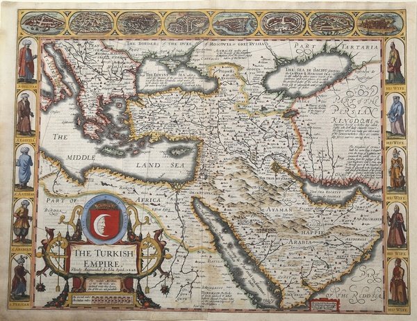
The Turkish Empire newly augmented by John Speed 1626
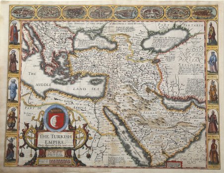
The Turkish Empire newly augmented by John Speed 1626
Formas de Pago
- PayPal
- Tarjeta de crédito
- Transferencia Bancaria
- Pubblica amministrazione
- Carta del Docente
Detalles
- Año de publicación
- 1626
- Lugar de impresión
- Londra
- Formato
- 515 X 397
- Grabadores
- SPEED John
Descripción
Bellissima carta a colori dell'Impero turco di John Speed. Una delle mappe più decorative dell'Impero Ottomano pubblicate nel XVII secolo. La prima carta della regione pubblicata in Inghilterra, decorata con 8 piante di città turche e 10 figure in costume e un grande cartiglio. Questa splendida ' carte-a-figure ' copre le regioni dalla Grecia a tutto il Medio Oriente, inclusa la Persia, l'Arabia, il Mar Nero, il Mar Caspio e il Mar Rosso. Pubblicata nell'atlante di John Speed "A Prospect of the most famous part of the World" - nella rara edizione del 1676, con l'imprint di Roger Rea. L'interno è fittamente inciso con montagne e deserti, numerose città e villaggi con quelli principali evidenziate in grassetto. Nel margine superiore sono otto vedute a volo d'uccello di città, tra cui Damasco, Gerusalemme, Costantinopoli, Rodi, Alessandria. Il cartiglio con il titolo presenta la mezzaluna sormontata da una corona. Lungo il lato sinistro sono cinque ritratti di uomini greci, egiziani, assiri, arabi e persiani e, a destra, cinque ritratti delle loro rispettive mogli. Numerose sono le annotazioni nella mappa, con dettagli storici e geografici. La data indicata nel cartiglio, 1626, è quella della prima edizione della lastra, mentre il testo inglese al verso fornisce un affascinante descrizione della regione. John Speed nacque nel 1552 a Farndon, nel Cheshire. Inizialmente seguì il mestiere di sarto del padre fino all'età di cinquant'anni. La sua vera professione fu, fin da giovane, quella di cartografo e storico dilettante, su cui si concentrò con l'aiuto di Sir Fulke Greville. Come fonte per le sue mappe, Speed utilizzò il materiale di Saxton e Morden, ma considerò anche materiale aggiornato, soprattutto per le piante delle città inserite nelle sue mappe. Le sue mappe furono incise da Jodocus Hondius ad Amsterdam e spedite a Londra per la stampa. La prima edizione del suo Theatre of the Empire of Great Britain fu messa in vendita nel 1610-11 e fu ristampata fino al 1770. Nel 1627 pubblicò A Prospect of the Most Famous Parts of the World, il primo atlante mondiale prodotto da un inglese Incisione su rame, finemente colorata a mano, in ottimo stato di conservazione. Beautiful colored 'carte-à-figure' of the Turkish Empire by John Speed. One of the most decorative maps of Ottoman Empire issued in the 17th Century. The first map of the region published in England, decorated with 8 Turkish town plan and 10 costumed figures and a large cartouche. This splendid map covers the region from Greece across the Middle East to include Persia and Arabia, the Black and Caspian Seas, and the Red Sea. Published in the John Speed "A Prospect of the most famous part of the World" - edition of 1676, with Roger Rea's imprint. The interior is fully engraved with mountains and deserts, numerous towns and villages with the major ones highlighed in original gauche. Along the top are eight birds-eye views of eight important cities including Damascus, Jerusalem, Constantinople, Rhode, Alexandria, Ormus and Famagusta. The title cartouche features the crescent moon and a crown. Along each side are five full portraits of Greek, Egyptian, Assyrian, and Persian men on the left and their wives on the right. With numerous annotations in blank areas giving historical and geographical details. The date given is the date the plate was engraved; the English text on verso provides a fascinating contemporary description of the region. The map includes Italy in the northwest, Russian in the north, Tartaria, Persia and Arabia to the east and the northeast corner of Africa, much of which was controlled by the Ottomans at the time. On the verso in English is a comprehensive (for that time) description of the Ottomans, their origins, their history, traditions and religion. The so-called Turkish Empire, which was in fact the Ottoman Empire, was one of the mightiest and longest-lasting dynasties in world history. This superpower ruled large areas of the Middle East, Eastern Europe and North Africa for more than 600 years. The head of state was a Sultan who had absolute religious and political authority over his people. Western Europeans generally viewed them as a threat, but many historians regard the Ottoman Empire as a source of great regional stability and security, and of important achievements in the arts, science, religion and culture as well. The Ottomans allowed freedom of worship in occupied territories, and in general governed with a loose rein so long as taxes were paid when due. This fascinating map includes interesting commentary regarding the various peoples of the regions depicted. For example, reference is made to Prester John, the legendary Nestorian-Christian emperor or king-priest who, according to various reports, was supposed to have ruled in the far east beyond Persia and Armenia. Speed places him in Abyssinia. Eight major cities including Alexandria, Constantinople and Jerusalem are depicted in vignettes along the top of the map, and running down either side are vignettes portraying husbands and wives of different peoples, including Greeks, Egyptians, Assyrians, Arabians and Persians clothed in native raiment. Text inside a small cartouche states that the map is available in Fleet Street and in St. Paul’s Churchyard in London. John Speed was born 1552 at Farndon in Cheshire. First followed his father trade as a tailor until the age of fifty. His real profession was from early age map making an historian as an amateur, and he focused on this with the help of Sir Fulke Greville. As source for his maps, Speed used material from Saxton and Morden, but he also considered up-to-date material especially for the inset town plans on his maps. The maps have been engraved by Jodocus Hondius in Amsterdam and shipped back to London for printing. The first edition of his ' Theatre of the Empire of Great Britain ' came to sale 1610-11 and was re-issued until 1770. In 1627 he published ' A Prospect of the Most Famous Parts of the World, the first World Atlas produced by an Englishman. Re-issues have been published until 1676. Copper engraving, with fine later hand colour, in very good condition. Cfr.