Theatre de la Guerre entre les Russes, Les Turcs, et Les Polonois. Tire du Cabinet de M. le Marquis de Paulmy Ministre d'Eta
Theatre de la Guerre entre les Russes, Les Turcs, et Les Polonois. Tire du Cabinet de M. le Marquis de Paulmy Ministre d'Eta | Grabados | ROUGE Georg Louis le
Theatre de la Guerre entre les Russes, Les Turcs, et Les Polonois. Tire du Cabinet de M. le Marquis de Paulmy Ministre d'Eta
Theatre de la Guerre entre les Russes, Les Turcs, et Les Polonois. Tire du Cabinet de M. le Marquis de Paulmy Ministre d'Eta | Grabados | ROUGE Georg Louis le
Formas de Pago
- PayPal
- Tarjeta de crédito
- Transferencia Bancaria
- Pubblica amministrazione
- Carta del Docente
Detalles
- Año de publicación
- 1769
- Lugar de impresión
- Parigi
- Formato
- 1350 X 500
- Grabadores
- ROUGE Georg Louis le
Descripción
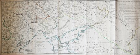
Rara mappa che illustra il Teatro della guerra russo-turca (1768-1774).La mappa si focalizza sui territori situati sulle coste settentrionali e occidentali del Mar d’Azov e del Mar Nero e della Crimea, ovvero Bulgaria, Romania, Moldavia, Ucraina (allora parte della Polonia) e Russia, che si estendono fino ad Astracan e al Mar Caspio.La mappa è tratta da carte manoscritte realizzate a partire dall'ultima guerra russo-turca che si è svolta tra il 1735 e il 1739. In alto a destra si trova il resoconto dettagliato della guerra precedente, con l’indicazione delle date importanti, delle battaglie e di altri fattori che hanno portato all’attuale situazione politica descritta dalla mappa. La carta illustra le nuove città e i forti costruiti dai russi, lungo il Dnieper e il Don, e nelle città di Orel e Samara.Acquaforte con coloritura coeva dei contorni, più volte ripiegata, in buono stato di conservazione. Fine example of this rare map illustrating the Theater of Russo-Turkish War (1768-1774).The map emphasizes the territories located on the north and west coasts of the Sea of Azov and the Black Sea and Crimea, namely Bulgaria, Romania, Moldova, Ukraine (then part of Poland) and Russia, extending to Astracan and the Caspian Sea.The map is drawn from handwritten maps drawn up since the last Russian-Turkish war which took place between 1735 and 1739, most notably New Servia, territory bordering the new Russian-Turkish border in Ukraine, which was won by the Russians during this war. At the top right is detailed accounting of the prior war, setting for the important dates, battles and other factors leading to the current map.The map illustrates the new cities and forts built by the Russians, along the Dnieper and the Don, and in the cities of Orel and Samara. Copperplate with original outline colour, usual folds, good condition. Cfr.
