Detalles
Lugar de impresión
Venezia
Grabadores
RUSCELLI Girolamo
Descripción
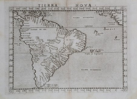
Seconda mappa dell’intera parte meridionale del continente dopo quella di Giacomo Gastaldi (1548). La mappa copre l'intero continente e parte dell'America centrale, sono mostrate alcune isole dei Caraibi, è raffigurata una parte della costa occidentale dell'Africa vicino alla Guinea, insieme ad alcune isole al largo della costa occidentale. Il Sud America orientale tra l'equatore e il Tropico del Capricorno conserva ancora il suo rigonfiamento impreciso nell'Atlantico. Numerosi toponimi seguono la configurazione del continente, quasi tutti lungo le coste. Si notano gli Stretti di Magellano, con raffigurato solo il bordo settentrionale della Terra del Fuoco. Nell'entroterra, il sistema del Rio delle Amazzoni è raffigurato come da sud a nord piuttosto che da ovest a est, e il Rio de la Plata è delineato. Il nome dell'area più ampia che prima si chiamava Santa Cruz e Veracruz, è già stato sostituito da Terra do Brasil. Sono incluse numerose catene montuose, ma la lunga catena delle Ande è rappresentata da una catena medio-continentale che è molto più corta che nella realtà. Vengono menzionate alcune città inca nella provincia del Perù, tra cui Cusco e Caxamalca. Carta tratta dalla ' Geographia di Claudio Tolomeo, a cura di Girolamo Ruscelli, pubblicata in Venezia in più edizioni tra il 1561 ed il 1598. La carta è basata sulla “Geografia” di Giacomo Gastaldi (1548), che probabilmente disegnò personalmente anche queste mappe, che vennero incise dai fratelli Livio e Giulio Sanuto. La peculiarità di queste mappe è che sono incise due per lastra e successivamente tagliate; questo il motivo per cui il segno del rame appare solo in tre lati della mappa. Il testo del Ruscelli e le sue carte sono considerate come il miglior atlante moderno fino alla prima versione del ' Theatrum ' ' Orbis Terrarum ' di Abraham Ortelius (1570). Solo la loro larga diffusione ne impedisce una valutazione sostenuta nel mercato antiquario. L'opera infatti ebbe una prima stesura nel 1561, stampata da Vincenzo Valgrisi che ne curò anche la ristampa del 1562. Tre sono le edizioni firmate da Giordano Ziletti (due nel 1564 e una del 1574), mentre nel 1597 viene edita dai fratelli Calignani. Tutte queste edizioni contengono 64 tavole. Nel 1598 e 1599 vengono alla luce le due edizioni curate da Giuseppe Rosaccio e stampate dagli Eredi di Melchior Sessa. Queste ultime due edizioni comprendono 69 tavole; sono infatti aggiunte la carta del planisfero e dei continenti di Rosaccio. Acquaforte e bulino, in ottimo stato di conservazione. The map covers the entire continent and part of Central America, a few islands in the Caribbean are shown, a portion of the west coast of Africa near Guinea is depicted, along with some islands off the west coast. Eastern South America between the equator and the Tropic of Capricorn yet retains its inaccurate bulge into the Atlantic. Numerous place names follow the configuration of the continent, with nearly all of them along the coastlines. The Straights of Magellan are noted, with just the northern edge of Tierra del Fuego depicted. Inland, the Amazon River system is depicted as running south to north rather than west to east, and the Plata is delineated. The name of the larger area which was first called Santa Cruz and Veracruz, has already been replaced by Terra do Brasil. A number of mountain ranges are included, but the long range of the Andes is represented by a mid-continental range which is much shorter than its true topography. A few Incan cities in Peru Provincia, including Cusco and Caxamalca, are mentioned. ' Map taken from ' Geographia di Claudio Tolomeo ' edited by Girolamo Ruscelli, published in Venice in several editions between 1561 and 1598. The maps is based on the ' Geografia ' by Giacomo Gastaldi (1548), who probably also personally drew these maps, which were engraved by the brothers Livio and Giulio Sanuto. The peculiarity of these maps is that they are engraved two for plate and subsequently cut; this is why the copper sign only appears on three sides of the map. Ruscelli's text and his maps are considered to be the best modern atlas up to the first version of Abraham Ortelius' ' Theatrum Orbis Terrarum ' (1570). Only their widespread diffusion prevents a sustained evaluation in the antiquarian market. In fact, the work had a first edition in 1561, printed by Vincenzo Valgrisi who also edited the 1562 reprint. There are three editions signed by Giordano Ziletti (two in 1564 and one in 1574), while in 1597 it was published by the Calignani brothers. All these editions contain 64 plates. In 1598 and 1599 the two editions edited by Giuseppe Rosaccio and printed by the heirs of Melchior Sessa came to light. These last two editions include 69 plates; in fact, Rosaccio's map of the planisphere and continents has been added. Etching and engraving, in good condition. Cfr.

 Descubre cómo utilizar
 Descubre cómo utilizar