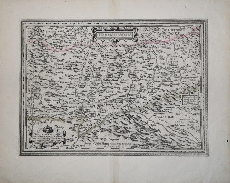
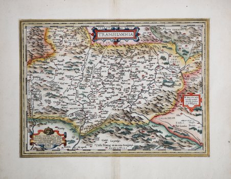
Transilvania
Transilvania
Formas de Pago
- PayPal
- Tarjeta de crédito
- Transferencia Bancaria
- Pubblica amministrazione
- Carta del Docente
Detalles
- Año de publicación
- 1570
- Lugar de impresión
- Anversa
- Formato
- 450 X 330
- Grabadores
- ORTELIUS Abraham
Descripción
Titolo in alto nel cartiglio decorato. Nel cartiglio in passo a sinistra: HANC VLTRA VEL TRAN:|SILVANIAM, QVÆ ET PÂNO|DACIA, ET DACIA RIPÊSIS, VVL:|GO SIBEMBVRGÊ DICITVR, | "edidit Viennæ Ao. 1566. Nobiliß. atque Doctiß. | Ioês Sâbucus | Pannonius". In basso al centro: "Vallis Hatzag Vbi olim ciuitas Sarmisgethusa". Nel cartiglio in basso a destra: "H. "Litera in hac tabula | nonnullis vocabulis | adiuncta significat | ea eße Hungarica". Bell'esemplare della mappa della Transilvania di Ortelius, dal suo ' Theatrum Orbis Terrarum, il primo atlante moderno. ' Seconda versione della carta della Transilvania di Ortelius, preparata nel 1575, dopo che la prima lastra si era probabilmente rotta. Deriva dalla mappa dell'Ungheria preparata da Giovanni Sambuco (un. Zsámboky János, lat. Johannes Sambucus) nel 1566, che è a sua volta basata sulla mappa di Honter del 1532. Copre l'attuale Romania centrale, raffigurando un'area che va dal fiume Körös a ovest fino a Bucarest a est, dal nord fino a Bistri?a e dal sud fino a Branizka e parte del basso Danubio. Compaiono, tra le altre, le città di Cluj-Napoca (Clausenburg), Alba Iulia, Bistri?a, Hermannstadt (Sibiu) Corona (Kronstadt / Brasov) e Bucarest (Bocaretz). Sebbene Ortelius abbia citato come fonte la mappa di Johannes Sambucus del 1566, questa venne copiata dalla Chorographia Transylvaniae di Johannes Honter del 1532, la prima mappa stampata della regione. Carta tratta dal ' Theatrum Orbis Terrarum ' e che è considerato il primo vero “atlante” moderno. L’opera fu pubblicata in 7 lingue e 36 edizioni, per il quale – nel 1570 - Ortelius ottenne il ' privilegio, ovvero una sorta di diritto d'autore che impediva ad altri cartografi di pubblicare i propri lavori. Il ' Theatrum ' rappresentava il lavoro più avanzato del lavoro della descrizione cartografica. L’Ortelius vi raccolse il sapere geografico e cartografico del suo tempo, proponendo in 147 spettacolari tavole incise l’immagine più fedele del mondo allora conosciuto e, in alcune straordinarie “carte storiche”, regioni e itinerari tratti dalla letteratura, dalla mitologia, dalla tradizione. Ortelius fu anche il primo a citare le fonti, menzionando i nomi dei cartografi nel “catalogus auctorum”. Dal 1598 al 1612 le edizioni postume del ' Theatrum ' furono realizzate dal suo collaboratore Johannes Baptiste Vrients. Secondo stato di quattro secondo Van den Brocke, stampato tra il 1587 e il 1598, dall'edizione latina del 1592. Incisione in rame, finemente colorata a mano, in ottimo stato di conservazione. Bibliografia Van den Broecke, Ort 153, II/IV; Koeman/Meurer 71/II; vdKrogtAN: 7700:31B; Gròf (1979) "The Map Collector" 6:2-11, (1992) "Cartographica Hungarica" 1:26-36. Title in the top cartouche. At lower left HANC VLTRA VEL TRAN:|SILVANIAM, QVÆ ET PÂNO|DACIA, ET DACIA RIPÊSIS, VVL:|GO SIBEMBVRGÊ DICITVR, | "edidit Viennæ Ao. 1566. Nobiliß. atque Doctiß. | Ioês Sâbucus | Pannonius". Centre bottom: "Vallis Hatzag Vbi olim ciuitas Sarmisgethusa". Cartouche lower middle right with four lines of text: "H. "Litera in hac tabula | nonnullis vocabulis | adiuncta significat | ea eße Hungarica". Nice ' example of Ortelius' map of Transylvania, from his ' Theatrum Orbis Terrarum, the first modern atlas. Second plate dedicated by Ortelius to Transilvania. The map is drawn from an early map of Hungary prepared by Giovanni Sambuco (un. Zsámboky János, lat. Johannes Sambucus) in 1566, which is in turn based upon Honter's map of 1532. Covering what is now central Romania. It is a superb engraving, dramatically presenting the mountains and forests of this frontier region of Europe and the Turkish Empire. The map covers an area from the Körös River in the west to Bucharest in the east and from as far north as Bistri?a and as far south as Branizka and part of the lower Danube. The cities of Cluj-Napoca (Clausenburg), Alba Iulia, Bistri?a, Hermannstadt (Sibiu) Corona (Kronstadt / Brasov), and Bucharest (Bocaretz) appear, among many others. Ortelius credited Johannes Sambucus' 1566 map, but this in turn was copied from Johannes Honter's 1532 Chorographia Transylvaniae, the first printed map of Transylvania. ' The ' Theatrum Orbis Terrarum, is considered the first true modern "Atlas". The work was published in 7 languages and 36 editions, for which - in 1570 - Ortelius obtained the privilege, a kind of copyright that prevented other cartographers from publishing his works. The ' Theatrum ' represented the most advanced work of cartographic description. Ortelius collected in it the geographical and cartographic knowledge of his time, proposing in 147 spectacular engraved plates the most faithful image of the world then known and, in some extraordinary "historical maps", regions and routes taken from literature, mythology, tradition. Ortelius was also the first to cite sources, mentioning the names of cartographers in the "catalogus auctorum". From 1598 to 1612 the posthumous editions of the ' Theatrum ' were made by his collaborator Johannes Baptiste Vrients. Copper engraving with fine later hand colour, in good condition. The second state of four of the plate according Van den Brocke, printed between 1587 and 1598, from the Latin edition of 1592. Bibliografia Van den Broecke, Ort 153, II/IV; Koeman/Meurer 71/II; vdKrogtAN: 7700:31B; Gròf (1979) "The Map Collector" 6:2-11, (1992) "Cartographica Hungarica" 1:26-36. Cfr.