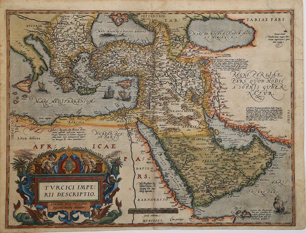
Turcici Imperii Descriptio.
Turcici Imperii Descriptio.
Formas de Pago
- PayPal
- Tarjeta de crédito
- Transferencia Bancaria
- Pubblica amministrazione
- Carta del Docente
Detalles
- Año de publicación
- 1570
- Lugar de impresión
- Anversa
- Formato
- 498 X 380
- Grabadores
- ORTELIUS Abraham
Descripción
Splendida mappa a colori del Medio Oriente, della Turchia e del Mediterraneo Orientale dalla Sicilia a Cipro, tratta dall'edizione tedesca del Theatrum Orbis Terrarum di Ortelius.La mappa è basata sulla mappa murale di Gastaldi in Asia. Include un cartiglio decorato, quattro velieri e mostri marini nel Mar Nero. Il ' Theatrum Orbis Terrarum ' è considerato il primo vero “atlante” moderno. L’opera fu pubblicata in 7 lingue e 36 edizioni, per il quale – nel 1570 - Ortelius ottenne il ' privilegio, ovvero una sorta di diritto d'autore che impediva ad altri cartografi di pubblicare i propri lavori. Il ' Theatrum ' rappresentava il lavoro più avanzato del lavoro della descrizione cartografica. L’Ortelius vi raccolse il sapere geografico e cartografico del suo tempo, proponendo in 147 spettacolari tavole incise l’immagine più fedele del mondo allora conosciuto e, in alcune straordinarie “carte storiche”, regioni e itinerari tratti dalla letteratura, dalla mitologia, dalla tradizione. Ortelius fu anche il primo a citare le fonti, menzionando i nomi dei cartografi nel “catalogus auctorum”. Dal 1598 al 1612 le edizioni postume del ' Theatrum ' furono realizzate dal suo collaboratore Johannes Baptiste Vrients. Incisione in rame, bellissima coloritura antica con ritocchi, in ottimo stato di conservazione. Gorgeous old color example of Ortelius' map of the Middle East, Turkey and the Eastern Mediterreanean from Sicily to Cyprus, from the German edition of Ortelius' Theatrum Orbis Terrarum. The map is based upon Gastaldi's wall map of Asia. Includes an ornate cartouche, four sailing vessels and sea monster in the Black Sea. Map taken from the ' Theatrum Orbis Terrarum, which is considered the first true modern "Atlas". The work was published in 7 languages and 36 editions, for which - in 1570 - Ortelius obtained the privilege, a kind of copyright that prevented other cartographers from publishing his works. The ' Theatrum ' represented the most advanced work of cartographic description. Ortelius collected in it the geographical and cartographic knowledge of his time, proposing in 147 spectacular engraved plates the most faithful image of the world then known and, in some extraordinary "historical maps", regions and routes taken from literature, mythology, tradition. Ortelius was also the first to cite sources, mentioning the names of cartographers in the "catalogus auctorum". From 1598 to 1612 the posthumous editions of the ' Theatrum ' were made by his collaborator Johannes Baptiste Vrients. Copperplate, with fine original colour, good condition. Cfr.