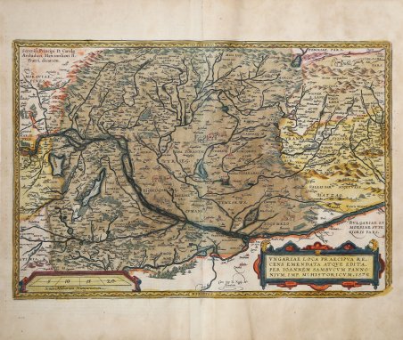
UNGARIAE LOCA PRAECIPVA RE:|CENS EMENDATA ATQUE EDITA, | PER IOANNEM SAMBUCUM PANNO:|NIVM IMP. Ms. HISTORICVM.1579. In basso al centro: "Cum Imp. et Regie Mt. | Priuilegio". All’angolo superior sinistro: Sereniss. Principi D. Carolo | Archiduci, Maximiliani II, | Fratri, Dicatum. Dedicata al serenissimo sovrano Carolus, arciduca, fratello di sua eccellenza Massimiliano secondo. Bella carta dell'Ungheria, della Transilvania orientale e della Bulgaria. Ortelius si è basato sulla carta dell'Ungheria di Sambucus, pubblicata a Vienna nel 1571. (Karrow 65/3, p. 460-461, Meurer p. 226-227). Carta tratta dal ' Theatrum Orbis Terrarum ' e che è considerato il primo vero “atlante” moderno. L’opera fu pubblicata in 7 lingue e 36 edizioni, per il quale – nel 1570 - Ortelius ottenne il ' privilegio, ovvero una sorta di diritto d'autore che impediva ad altri cartografi di pubblicare i propri lavori. Il ' Theatrum ' rappresentava il lavoro più avanzato del lavoro della descrizione cartografica. L’Ortelius vi raccolse il sapere geografico e cartografico del suo tempo, proponendo in 147 spettacolari tavole incise l’immagine più fedele del mondo allora conosciuto e, in alcune straordinarie “carte storiche”, regioni e itinerari tratti dalla letteratura, dalla mitologia, dalla tradizione. Ortelius fu anche il primo a citare le fonti, menzionando i nomi dei cartografi nel “catalogus auctorum”. Dal 1598 al 1612 le edizioni postume del ' Theatrum ' furono realizzate dal suo collaboratore Johannes Baptiste Vrients. Incisione in rame, bella coloritura coeva, in ottimo stato di conservazione. Edizione italiana del 1608, stampata da J. B. Vrients. Bibliografia M. Van den Broecke "Ortelius Atlas Maps" (2011), n. 150; L. Gróf (1979), "The Map Collector" 6: p. 2-11, (1992) "Cartographica Hungarica" 1: pp. 26-36. UNGARIAE LOCA PRAECIPVA RE:|CENS EMENDATA ATQUE EDITA, | PER IOANNEM SAMBUCUM PANNO:|NIVM IMP. Ms. HISTORICVM.1579. Middle bottom: "Cum Imp. et Regie Mt. | Priuilegio". Text block upper left corner: Sereniss. Principi D. Carolo | Archiduci, Maximiliani II, | Fratri, Dicatum. [Dedicated to the most serene ruler, Mr. Carolus, archduke, brother of his excellence Maximilian the second]. A handsome map of Hungary, eastern Transylvania and Bulgaria. Ortelius based this map on Sambucus' Hungary map, published in Vienna in 1571 (Karrow 65/3, p. 460-461, Meurer p. 226-227). The map is densely engraved with rivers, lakes, mountains and hundreds of place names, each represented by a tiny castle and tiny animals fill the blank spaces. The title spans the top of the map in a strapwork cartouche. At bottom right is a large decorative cartouche containing the rules for Hungarian consonant pronunciation of the place names. Map taken from the ' Theatrum Orbis Terrarum, which is considered the first true modern "Atlas". The work was published in 7 languages and 36 editions, for which - in 1570 - Ortelius obtained the privilege, a kind of copyright that prevented other cartographers from publishing his works. The ' Theatrum ' represented the most advanced work of cartographic description. Ortelius collected in it the geographical and cartographic knowledge of his time, proposing in 147 spectacular engraved plates the most faithful image of the world then known and, in some extraordinary "historical maps", regions and routes taken from literature, mythology, tradition. Ortelius was also the first to cite sources, mentioning the names of cartographers in the "catalogus auctorum". From 1598 to 1612 the posthumous editions of the ' Theatrum ' were made by his collaborator Johannes Baptiste Vrients. From the Italian edition of 1608. Copperplate with fine original colouring, very good condition. Bibliografia M. Van den Broecke "Ortelius Atlas Maps" (2011), n. 150; L. Gróf (1979), "The Map Collector" 6: p. 2-11, (1992) "Cartographica Hungarica" 1: pp. 26-36. Cfr.

 Descubre cómo utilizar
 Descubre cómo utilizar