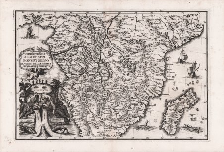
Utriusque Nili Albi et Atri fons et origo ex veris relationibus geographice exhibetur
Utriusque Nili Albi et Atri fons et origo ex veris relationibus geographice exhibetur | Grabados | SCHERER Henrick
Utriusque Nili Albi et Atri fons et origo ex veris relationibus geographice exhibetur
Utriusque Nili Albi et Atri fons et origo ex veris relationibus geographice exhibetur | Grabados | SCHERER Henrick
Formas de Pago
- PayPal
- Tarjeta de crédito
- Transferencia Bancaria
- Pubblica amministrazione
- Carta del Docente
Detalles
- Año de publicación
- 1703
- Lugar de impresión
- Monaco
- Formato
- 350 X 238
- Grabadores
- SCHERER Henrick
- Descripción
- Shirley (BL Atlases) T.SHER-1a #22.
Descripción
Decorativa carta geografica dell'Africa meridionale, con il Madagascar e le isole adiacenti, pubblicata nell'opera di Heinrich Scherer "Atlas Novus exhibens orbem terraguem per naturae opera, historiae navae acveterus monumenta, artistique geographicae leges et praecepta." edito in 8 parti, dal 1702 al 1710 a Monaco.La carta riflette la geografia dell'epoca, con la collocazione erronea di montagne, fiumi e laghi.Il Nilo è rappresentato con le sue due sorgenti che si originano dal Lago Zaire e Lago Zaflan a est.Siotto il cartiglio con il titolo, una bella vignetta allegorica con due divinità fluviali (rappresentate da un nigeriano e un egiziano) che simboleggia i fiumi Niger e Nilo. La mappa è ulteriormente arricchita con navi a vela e mostri marini.Incisione su rame, in ottimo stato di conservazione. Decorative map of central and southern Africa and Madagascar by Heinrich Scherer (1628-1704) for his Atlas Novus exhibens orbem terraguem per naturae opera, historiae navae acveterus monumenta, artistique geographicae leges et praecepta.published in eight volumes from 1702-1710 in Munich.Scherer, a devout Jesuit, produced this geographical compendium to depict the Catholic hierarchy and the spread of Jesuit missions throughout the world. The map is full of the spurious geography of the period with large lakes, rivers and mountains. The Nile is prominently featured with its twin tributaries coming out of Lake Zaire and Lake Zaflan to the east. The decorative title cartouche continues the theme with two river gods (represented by a Nigerian and an Egyptian) symbolizing the Niger and Nile Rivers, with crocodiles emerging from the waters. The map is further embellished with sailing ships and sea monsters.Copper engraving, in very good condition. Cfr. Shirley (BL Atlases) T.SHER-1a #22.
