Venezuela, cum parte Australi Novae Andalusiae
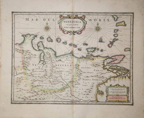
Venezuela, cum parte Australi Novae Andalusiae
Formas de Pago
- PayPal
- Tarjeta de crédito
- Transferencia Bancaria
- Pubblica amministrazione
- Carta del Docente
Detalles
- Año de publicación
- 1630
- Lugar de impresión
- Amsterdam
- Formato
- 496 X 380
- Grabadores
- JANSSONIUS Johannes
- Descripción
- Van der Krogt (Vol. I) #9830
Descripción
Questa bella mappa del Venezuela di Janssonius viene pubblicata nell'Atlas Major.La carta comprende anche le isole caraibiche da Aruba a Dominica e Tobago.Nell'interno, sono mostrate montagne, foreste, fiumi, mentre i toponimi sono riportati principalmente lungo le coste, rispecchiando le allora relativamente scarse conoscenze del territorio interno. Joannes Janssonius, figlio dell'editore di Arnhem Jan Janssen, sposò Elisabeth Hondius, figlia di Jodocus Hondius, ad Amsterdam nel 1612. Dopo il suo matrimonio, si stabilì in questa città come libraio ed editore di materiale cartografico. Nel 1618 si stabilì ad Amsterdam accanto alla libreria di Willem Jansz. Blaeu, entrando in una seria competizione. Le sue attività non riguardavano solo la pubblicazione di atlanti e libri, ma anche di mappe singole e un vasto commercio di libri con filiali a Francoforte, Danzica, Stoccolma, Copenaghen, Berlino, Koningsbergen, Ginevra e Lione. Nel 1631 iniziò a pubblicare atlanti insieme a Henricus Hondius. Nei primi anni 1640 Henricus Hondius lasciò l'attività di pubblicazione di atlanti completamente a Janssonius. La concorrenza con Joan Blaeu, figlio e successore di Willem, nella produzione di atlanti spinse Janssonius ad ampliare il suo Atlas Novus finalmente in un'opera di sei volumi, in cui furono inseriti un atlante marino e un atlante del Vecchio Mondo. Dopo la morte di Joannes Janssonius, il negozio e la casa editrice furono continuati dagli eredi sotto la direzione di Johannes van Waesbergen (c. 1616-1681), genero di Joannes Janssonius. Le matrici degli atlanti di Janssonius furono in seguito vendute a Schenk e Valck. Incisione su rame, bella coloritura coeva, due fori di tarlo in corrispondenza della piega centrale, lungo la quale si notano tracce di colla, nel complesso in buono stato di conservazione. This Venezuela map by Jansson is based on the cartography of Hessel Gerritsz. It covers the Venezuelan coast of South America, east to the mouth of the Orinoco, and includes the offshore islands from Aruba through Dominica and Tobago. The fine engraving illustrates the mountains, forests, rivers and missions in the interior, but shows place names primarily along the coastlines owing to the relatively few explorations made into the interior. The map is embellished with title and distance scale cartouches, a pair of compass roses and a galleon in the sea.From the Latin edition of the Atlas Major. Joannes Janssonius (Arnhem, 1588-1664), son of the Arnhem publisher Jan Janssen, married Elisabeth Hondius, daughter of Jodocus Hondius, in Amsterdam in 1612. After his marriage, he settled down in this town as a bookseller and publisher of cartographic material. In 1618 he established himself in Amsterdam next door to Blaeu’s book shop. He entered into serious competition with Willem Jansz. Blaeu. His activities not only concerned the publication of atlases and books, but also of single maps and an extensive book trade with branches in Frankfurt, Danzig, Stockholm, Copenhagen, Berlin, Koningsbergen, Geneva, and Lyon. In 1631 he began publishing atlases together with Henricus Hondius. In the early 1640s Henricus Hondius left the atlas publishing business completely to Janssonius. Competition with Joan Blaeu, Willem’s son and successor, in atlas production prompted Janssonius to enlarge his Atlas Novus finally into a work of six volumes, into which a sea atlas and an atlas of the Old World were inserted. After the death of Joannes Janssonius, the shop and publishing firm were continued by the heirs under the direction of Johannes van Waesbergen (c. 1616-1681), son-in-law of Joannes Janssonius. The copperplates from Janssonius’s atlases were afterwards sold to Schenk and Valck. Copper engraving, contemporary old coloured, two worm holes along the center fold, otherwise in good condition. Cfr. Van der Krogt (Vol. I) #9830