A Historic Buildings Map of the Peak District and Sherwood Forest
A Historic Buildings Map of the Peak District and Sherwood Forest | Rare and modern books | Peace, D. B.
Rare and modern books
Peace, D. B.
Architectural Maps,
1953


A Historic Buildings Map of the Peak District and Sherwood Forest
A Historic Buildings Map of the Peak District and Sherwood Forest | Rare and modern books | Peace, D. B.
Rare and modern books
Peace, D. B.
Architectural Maps,
1953
9.25 €
(Hyde,
United Kingdom)
Payment methods
- PayPal
- Credit card
- Bank transfer
- Pubblica amministrazione
- Carta del Docente
Details
- Year of publication
- 1953
- Place of printing
- Stafford
- Author
- Peace, D. B.
- Publishers
- Architectural Maps
- Size
- 29.25 x 21.75 Inches
- Keyword
- Map. Peak District, Heraldry, Sherwood Forest
- Binding description
- S
- Dust jacket
- False
- State of preservation
- Very Good
- Languages
- English
- Binding
- Softcover
- Inscribed
- False
- First edition
- False
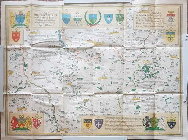
Description
Folded map. No marks or inscriptions. No creasing to covers. A very clean very tight copy, bright unmarked, not torn and no bumping to corners. 1pp. Some 450 historic buildings, including 228 churches, are illustrated on the map from sketches and with Heraldic Emblems. On the reverse side is a comprehensive guide arranged alphabetically to the places of interest in towns and villages from Abney to Youlgreave. The map covers parts of Yorkshire West Riding, Cheshire, Staffordshire, Derbyshire and Nottinghamshire. Both map sides are held open to photograph with laid-on metal supports.
