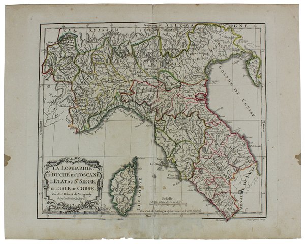
LA LOMBARDIE, LE DUCHÉ DE TOSCANE, L'ETAT DU ST. SIEGE, E L'ISLE DE CORSE. [Carta geografica del 1778]
LA LOMBARDIE, LE DUCHÉ DE TOSCANE, L'ETAT DU ST. SIEGE, E L'ISLE DE CORSE. [Carta geografica del 1778] | Rare and modern books | Vaugondy Robert, Dussy E.


LA LOMBARDIE, LE DUCHÉ DE TOSCANE, L'ETAT DU ST. SIEGE, E L'ISLE DE CORSE. [Carta geografica del 1778]
LA LOMBARDIE, LE DUCHÉ DE TOSCANE, L'ETAT DU ST. SIEGE, E L'ISLE DE CORSE. [Carta geografica del 1778] | Rare and modern books | Vaugondy Robert, Dussy E.
Payment methods
- PayPal
- Credit card
- Bank transfer
- Pubblica amministrazione
- Carta del Docente
Details
- Year of publication
- 1778
- Place of printing
- Paris
- Author
- Vaugondy Robert, Dussy E.
- Publishers
- Chez le Sr. Fortin,
- Keyword
- CARTE GEOGRAFICHE, ITALIA - TOSCANA, ITALIA - LOMBARDIA
Description
(Codice TM/2473) Carta geografica, incisione su rame, carta vergata, confini anticamente acquerellati a mano. Dimensioni totali 290x360 mm. Dimensioni dell'incisione 260x310 mm ca. La carta proviene dal "Nouvel Atlas Portatif pour la jeunesse, d'après La Géographie Moderne de feu l'Abbé Delacroix" (Alleghiamo fotocopia del frontespizio). Il cartiglio sulla carta è opera di Arrivet. Gilles Robert de Vaugondy (1688-1766), noto anche come Le Sieur or Monsieur Robert, e suo figlio Didier Robert de Vaugondy (c.1723-1786), furono famosi cartografi in Francia durante il 18° secolo. Lievi ingialliture, macchiette marginali, segno centrale di piega, riparato al verso, alonato il margine centrale inferiore restaurato. Complessivamente in buono stato. ~~~ SPEDIZIONE IN ITALIA SEMPRE TRACCIATA
