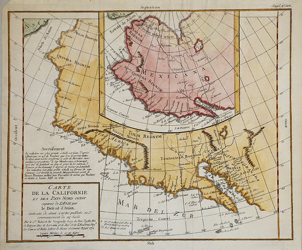
Carte de la Californie et des Pays Nord Ovest separés de l'Asie par le Detroit d'Anian…
Carte de la Californie et des Pays Nord Ovest separés de l'Asie par le Detroit d'Anian… | Prints | VAUGONDY Didier Robert de

Carte de la Californie et des Pays Nord Ovest separés de l'Asie par le Detroit d'Anian…
Carte de la Californie et des Pays Nord Ovest separés de l'Asie par le Detroit d'Anian… | Prints | VAUGONDY Didier Robert de
Payment methods
- PayPal
- Credit card
- Bank transfer
- Pubblica amministrazione
- Carta del Docente
Details
- Year of publication
- 1772
- Place of printing
- Parigi
- Size
- 375 X 315
- Engravers
- VAUGONDY Didier Robert de
Description
Carta della California e dello stretto di Anania (oggi Bering) tratta dalla celebre enciclopedia di Diderot e d'Alambert. Questa mappa fa parte delle 10 serie di carte preparate da Vaugondy per il Supplemento all'Enciclopedia di Diderot. Questa serie di importantissime carte, esplorando la mappatura del Nord America e in particolare del Passaggio a nord-ovest, rappresenta uno dei primi studi comparativi di cartografia.Incisione in rame, finemente colorata a mano, in ottimo stato di conservazione. Fascinating study in the comparative cartography of the West Coast of North America, from the Straits of Anian to Cabo San Lucas and the southern tip of Baja California. The work consists of extracts from two maps, both reportedly done by Visscher in the 1612 and 1641 respectively and with information derived from Mercator and Plancius. The larger map prominently shows the Strait of Anian, Anian Regnum, Quivira Regnum, the Sierra Nevada, Nova Albion, Tontonteac Regnum, Tolm Regnum and a coastal detail which includes over 30 coastal place names, including Mendocino, San Miguel (San Diego), Cape Fortuna, I. De Paxaros (Catalina?), and many mythical/ephemeral place names. The smaller map also shows the Straits of Anian, but depicts an open sea above, clearly portending a NW Passage in the Arctic Circle. The NW Coastline differs radically, and only Anian Regnum and Quivira Regnum are located, that later considerably south of the location on the larger map. The smaller map includes a similar number of coastal placenames, but includes several important ones not listed on the larger map, including C. Blanco (3 times), C. de San Francisco and los Farilones, but ommits any significant effort to depict bays. Diderot's work is part of a 10 map supplement to his Encyclopedia, and provides one of the most fascinating studies in contemporary comparative cartography which can be obtained by collectors, much of which is dedicated to the NW Coast. This map is part of the 10 map series prepared by Vaugondy for the Supplement to Diderot's Encyclopédie, of which this is plate 2. This seminal map series, exploring the mapping of North American and specifically the Northwest Passage was one of the first studies in comparative cartography.Copperplate, fine later hand colour, very good condition. Cfr.
