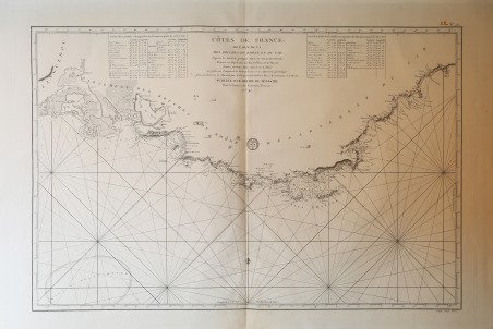
Cotes de France départements des Bouches du Rhone et du Var.
Cotes de France départements des Bouches du Rhone et du Var. | Prints | Anonimo


Cotes de France départements des Bouches du Rhone et du Var.
Cotes de France départements des Bouches du Rhone et du Var. | Prints | Anonimo
Payment methods
- PayPal
- Credit card
- Bank transfer
- Pubblica amministrazione
- Carta del Docente
Details
- Year of publication
- 1792
- Place of printing
- Parigi
- Size
- 870 X 615
- Engravers
- Anonimo
Description
- le carte edite dal Depot de la Marine -Per contrastare lo strapotere navale della flotta inglese re Luigi XIV comprese la necessita di dotare le sue navi di carte nautiche in grado di renderle competitive con la marina antagonista. Un primo tentativo si ebbe con il Neptune Francais del 1693, ma solo agli inizi del diciottesimo secolo iniziò una grande campagna di rilievo delle coste del Mediterraneo e di altri mari, che portò alla realizzazione di numerose mappe, raccolte nel Dépot des Cartes et Planes de la Marine del 1720. Tuttavia il fondatore dell’idrografia francese può essere considerato a tutti gli effetti Jacques Nicolas Bellin (1703-1772) che per oltre cinquant’anni fu al servizio della Marina quale ingegnere e cartografo, tanto che gli venne assegnato il titolo quale primo “Ingegnere Idrografo della Marina” e quindi addirittura quello di “Idrografo Reale”. Durante il suo servizio gli furono commissionati i rilievi delle coste francesi prima e successivamente quelle di praticamente tutto il mondo conosciuto. La sua produzione fu immensa e le sue carte nautiche, di grande qualità, apparvero in più edizioni fino oltre la fine del diciottesimo secolo. Questo grande fondo cartografico diede vita alla produzione ed alla vendita di carte navali, prima basate su quelle del Bellin, successivamente ampliate e migliorate da altri ingegneri di marina, sia francesi che non. Le carte nautiche venivano vendute separatamente e recavano tutte l’inconfondibile timbro con l’ancora e le corone (quando regnava la monarchia) del Depot Generale de la Marine. Raccolte delle stesse carte venivano invece pubblicate sotto il nome di Neptune Francois, monumentale opera che ebbe numerosissime ristampe fino alla metà del secolo successivo. Il seguente gruppo di carte è tratto da un volume denominato Neptune de la Méditerranée, riguardante il Mediterraneo. Dove possibile sono indicati il nome del cartografo, spesso un capitano di vascello, e la data della carta. Incisioni in rame, in eccellente stato di conservazione, salvo controindicazioni. Grande carta nautica delle coste della Provenza, da Villefranche alle foci del Rodano. To fight against the powerful English fleet, king Louis XIV decided to endow his ships with nautical charts that could enable them to compete with the enemy. The Neptune Francais, in 1693, can be considered a first attempt, but it was only at the beginning of the Eighteenth century that a campaign of study of the Mediterranean coasts and sea was started, leading to the realization of maps, collected in the Dépot des Cartes et Planes de la Marine in 1720. Nevertheless, the real founder of French hydrography can be considered Jacques Nicolas Bellin (1703-1772), who served for more than fifty years the navy as engineer and cartographer, which win him first the title of "Hydrographer Engineer of the Navy" and then of "Royal Hydrographer". His first commitment was to study the French coasts fisrt, and then of the whole world. His production was massive and his nautical charts, due also to their quality, were published in many edition until the end of the XVIII century. This allowance led to the production and the selling of sea charts, at first based on those from Bellin, then developed by other navy engineers. The sea charts were sold separately, all bearing the stamp with the anchor and the crowns of the Depot Generale de la Marine. Collections of the same charts have been published under the name of Neptune Francois, a monumental work which has been reissued many times until the half of the following century. The following group of charts is taken from a volume entitled Neptune de la Méditerranée, about the Mediterranean sea. Where possible, there is the name of the cartographer, very often the captain of the ship, and the date of the chart. Engravings, in excellent condition. Cfr.
