Exactissima Tabula qua tam Danubii Fluvii Pars Inferoir, a Belgrado Urbe usq ad Ejus Ostia, et Minores in eum Influentes Flu
Exactissima Tabula qua tam Danubii Fluvii Pars Inferoir, a Belgrado Urbe usq ad Ejus Ostia, et Minores in eum Influentes Flu | Prints | VISSCHER I Nicolas

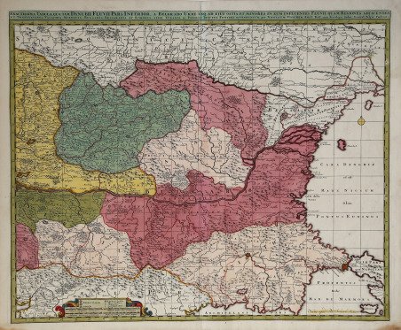

Exactissima Tabula qua tam Danubii Fluvii Pars Inferoir, a Belgrado Urbe usq ad Ejus Ostia, et Minores in eum Influentes Flu
Exactissima Tabula qua tam Danubii Fluvii Pars Inferoir, a Belgrado Urbe usq ad Ejus Ostia, et Minores in eum Influentes Flu | Prints | VISSCHER I Nicolas
Payment methods
- PayPal
- Credit card
- Bank transfer
- Pubblica amministrazione
- Carta del Docente
Details
- Year of publication
- 1677
- Place of printing
- Amsterdam
- Size
- 590 X 480
- Engravers
- VISSCHER I Nicolas
Description
Edizione di Peter Schenk della mappa dettagliata del Danubio inferiore di Nicolas Visscher, che si estende da Belgrado al Mar Nero. Edita circa nel 1720.La mappa si estende da Costantinopoli e lo stretto del Bosforo a sud-est fino all'Ucraina e alla Podolia a nord-est, e dal nord della Grecia a sud-ovest fino alla parte meridionale del Regno di Polonia a nord-ovest, incentrata sulla Bulgaria e la Valacchia.Acquaforte su rame, con una bella colorazione originale, buone condizioni. Peter Schenk edition of the Nicolas Visscher's detailed map of the lower Danube, extending from Belgrade to the Black Sea. Issued circa 1720.The map extends to Constantinople and the Bosphorus Straits in the southeast to the Ukraine and Podolia in the northeast, and from northern Greece in the southwest to the southern part of the Kingdom of Poland in the northwest, centered on Bulgaria and Valachia.Copperplate with fine original colouring, good condition. Cfr.
