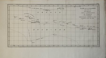
Kaart van de Eilanden in den omtrek van Otahiti…
Kaart van de Eilanden in den omtrek van Otahiti… | Prints | COOK James
Kaart van de Eilanden in den omtrek van Otahiti…
Kaart van de Eilanden in den omtrek van Otahiti… | Prints | COOK James
Payment methods
- PayPal
- Credit card
- Bank transfer
- Pubblica amministrazione
- Carta del Docente
Details
- Year of publication
- 1774
- Place of printing
- Venezia
- Size
- 520 X 250
- Engravers
- COOK James
- Keyword
- Pacifico e Oceania
Description
Carta geografica tratta dall'atlante della relazione di James Hawkesworth "Cartes et figures des voyages entrepris par ordre de sa Majesté Britannique pou fair des découvertes dans l'hémisphère méridional; exécutes par Byron, Carteret, Wallis & Cook dans les vaisseaux le Dauphin, Le Swallow & l'Endeavour" pubblicata in più edizioni di lingua francese, inglese, olandese ed italiano. Map of the atlas is the report by James Hawkesworth "Cartes et figures des voyages entreprise par ordre de sa Majesté Britannique pou fair des découvertes dans l'Hémisphère southern exécutes par Byron, Carteret, Wallis and Cook dans les vaisseaux le Dauphin, Le Swallow & Endeavour "published in multiple editions of the English, French, Dutch and Italian.A map of Tahiti and the surrounding islands discovered by Wallis, Carteret and Cook in the years 1765, 1767 and 1769. Cfr.
