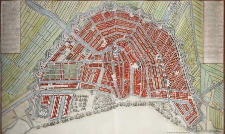
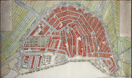
Plan de la grande & fameuse ville marchande d'Amsterdam Plan van de wyd vermaarde en beroemde koop stad Amsterdam
Plan de la grande & fameuse ville marchande d'Amsterdam Plan van de wyd vermaarde en beroemde koop stad Amsterdam | Prints | COVENS Johannes

Plan de la grande & fameuse ville marchande d'Amsterdam Plan van de wyd vermaarde en beroemde koop stad Amsterdam
Plan de la grande & fameuse ville marchande d'Amsterdam Plan van de wyd vermaarde en beroemde koop stad Amsterdam | Prints | COVENS Johannes
Payment methods
- PayPal
- Credit card
- Bank transfer
- Pubblica amministrazione
- Carta del Docente
Details
- Year of publication
- 1715
- Place of printing
- Amsterdam
- Size
- 970 X 566
- Engravers
- COVENS Johannes
- Inscription description
- M. Hameleers, Kaarten van Amsterdam, 104.
Description
Sesto ed ultimo stato di questa rara e grande pianta a volo d'uccello di Amsterdam, pubblicata per la prima volta nel 1715 da Johannes Covens e Cornelis Mortier. La prima stesura della mappa prevedeva un cartiglio decorativo - con putti, ghirlande di frutta e lo stemma di Amsterdam - in basso.La mappa si basa sulla pianta della città compilata nel 1662 dall'architetto Daniel Stalpaert e pubblicata da Nicolas Visscher, che registrava l'aggiunta dei canali dell'anello alla città iniziata nel 1613. La pianta mostra le strade, i canali, le chiuse, i blocchi di città e una serie di importanti punti di riferimento in modo molto dettagliato. Le strade sono numerate e codificate nei cartigli che affiancano la mappa, che elencano ben 299 strade. La città è suddivisa in 14 quartieri, numerati con i punti salienti dorati. Decine di galeoni riempiono il lungomare, a dimostrazione dell'importanza del commercio olandese dell'epoca, e numerosi mulini a vento circondano la città. Acquaforte, stampata su due fogli, finemente colorata a mano, in ottimo stato di conservazione. Sixth and final state of this rare, two-sheet bird’s-eye plan of Amsterdam first issued in 1715 by Nicolas Visscher with a decorative title cartouche - features putti, garlands of fruit, and the coat of arms of Amsterdam – at the bottom.The map is based on the city plan compiled in 1662 by architect Daniel Stalpaert and published by Nicolas Visscher, which recorded the addition of the Ring Canals to the city that had begun in 1613. The plan shows the streets, canals, locks, city blocks, and a number of important landmarks in great detail. The streets are numbered and keyed to columns flanking the map, listing an impressive 299 streets. The city is divided into 14 districts, which are numbered with gilt highlights. Dozens of galleons fill the waterfront, demonstrating the importance of Dutch trade at the time, and numerous windmills surround the city. Printed on two sheets, joined as issued.Copperplate with fine later hand colour, in good condition. Cfr. M. Hameleers, Kaarten van Amsterdam, 104.
