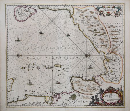
Sinus Gangeticus, Vulgo Golfo de Bengala Nova descriptio
Sinus Gangeticus, Vulgo Golfo de Bengala Nova descriptio | Prints | JANSSONIUS Johannes

Sinus Gangeticus, Vulgo Golfo de Bengala Nova descriptio
Sinus Gangeticus, Vulgo Golfo de Bengala Nova descriptio | Prints | JANSSONIUS Johannes
Payment methods
- PayPal
- Credit card
- Bank transfer
- Pubblica amministrazione
- Carta del Docente
Details
- Year of publication
- 1659
- Place of printing
- Amsterdam
- Size
- 545 X 475
- Engravers
- JANSSONIUS Johannes
Description
Mappa del golfo del Bengala, che si estende da Ceylon (Sri Lanka) fino allle coste settentrionali di Sumatra. Orientata con il nord a destra, la tavola apparve nell'atlante nautico di Jan Jansson, "Waterwereld", che costituiva il quinto volume del suo "Atlas Novus". È una delle poche prime mappe nautiche incentrate sulla regione. Johannes Janssonius, figlio dell'editore di Arnhem Jan Janssen, sposò Elisabeth Hondius, figlia di Jodocus Hondius, ad Amsterdam nel 1612. Dopo il suo matrimonio, si stabilì in questa città come libraio ed editore di materiale cartografico. Nel 1618 si stabilì ad Amsterdam accanto alla libreria di Willem Jansz. Blaeu, entrando in una seria competizione. Le sue attività non riguardavano solo la pubblicazione di atlanti e libri, ma anche di mappe singole e un vasto commercio di libri con filiali a Francoforte, Danzica, Stoccolma, Copenaghen, Berlino, Koningsbergen, Ginevra e Lione. Nel 1631 iniziò a pubblicare atlanti insieme a Henricus Hondius. Nei primi anni 1640 Henricus Hondius lasciò l'attività di pubblicazione di atlanti completamente a Janssonius. La concorrenza con Joan Blaeu, figlio e successore di Willem, nella produzione di atlanti spinse Janssonius ad ampliare il suo Atlas Novus finalmente in un'opera di sei volumi, in cui furono inseriti un atlante marino e un atlante del Vecchio Mondo. Dopo la morte di Joannes Janssonius, il negozio e la casa editrice furono continuati dagli eredi sotto la direzione di Johannes van Waesbergen (c. 1616-1681), genero di Joannes Janssonius. Le matrici degli atlanti di Janssonius furono in seguito vendute a Schenk e Valck. Acquaforte su rame, con un bel colore originale, in buone condizioni. Map of the Bay of Bengal from Ceylan (Sri Lanka) to Sumatra.This map appeared in Jan Jansson's sea-atlas, "Waterwereld", which formed a section of Volume V of his Novus Atlas. European and Oriental vessels are shown crossing the sea.One of the earliest obtainable Dutch Sea Charts of the region. Johannes Janssonius (Arnhem, 1588-1664), son of the Arnhem publisher Jan Janssen, married Elisabeth Hondius, daughter of Jodocus Hondius, in Amsterdam in 1612. After his marriage, he settled down in this town as a bookseller and publisher of cartographic material. In 1618 he established himself in Amsterdam next door to Blaeu’s book shop. He entered into serious competition with Willem Jansz. Blaeu. His activities not only concerned the publication of atlases and books, but also of single maps and an extensive book trade with branches in Frankfurt, Danzig, Stockholm, Copenhagen, Berlin, Koningsbergen, Geneva, and Lyon. In 1631 he began publishing atlases together with Henricus Hondius. In the early 1640s Henricus Hondius left the atlas publishing business completely to Janssonius. Competition with Joan Blaeu, Willem’s son and successor, in atlas production prompted Janssonius to enlarge his Atlas Novus finally into a work of six volumes, into which a sea atlas and an atlas of the Old World were inserted. After the death of Joannes Janssonius, the shop and publishing firm were continued by the heirs under the direction of Johannes van Waesbergen (c. 1616-1681), son-in-law of Joannes Janssonius. The copperplates from Janssonius’s atlases were afterwards sold to Schenk and Valck. Cfr.
